Hurricane Humberto and Tropical Storm Imelda may be churning up rough surfs and winds in the Caribbean Atlantic at the same time, but meteorologists now say East Coast residents have nothing to worry about.
The National Hurricane Center says neither of the two concurrent hurricanes are expected to impact Atlantic coastal states, but could affect riptides and currents in the coming days.

According to USA TODAY, the National Hurricane Center said both hurricanes are moving inward toward the Atlantic basin as of Monday, Sept. 29.
Read on to see where Hurricane Humberto is as of Monday, and see how both Humberto and Imelda could affect the Westchester, New York City and Long Island region.
Where is Hurricane Humberto?
Humberto became a Category 4 storm over the weekend and is currently over 300 miles off the coast of Bermuda with a maximum wind speed of around 145 mph.
The hurricane is expected to get its closest to the U.S. mainland on Tuesday, Sept. 30 around 8 a.m., when it will be several hundred miles off the coast of South Carolina before turning northwest and inward toward the open ocean. It is expected to dissolve by the weekend.
What to expect from Humberto and Imelda
Before it dissolves, Humberto and current Tropical Storm Imelda could create dangerous rip currents and high surf levels in the Caribbean and along the Atlantic coast starting Monday.
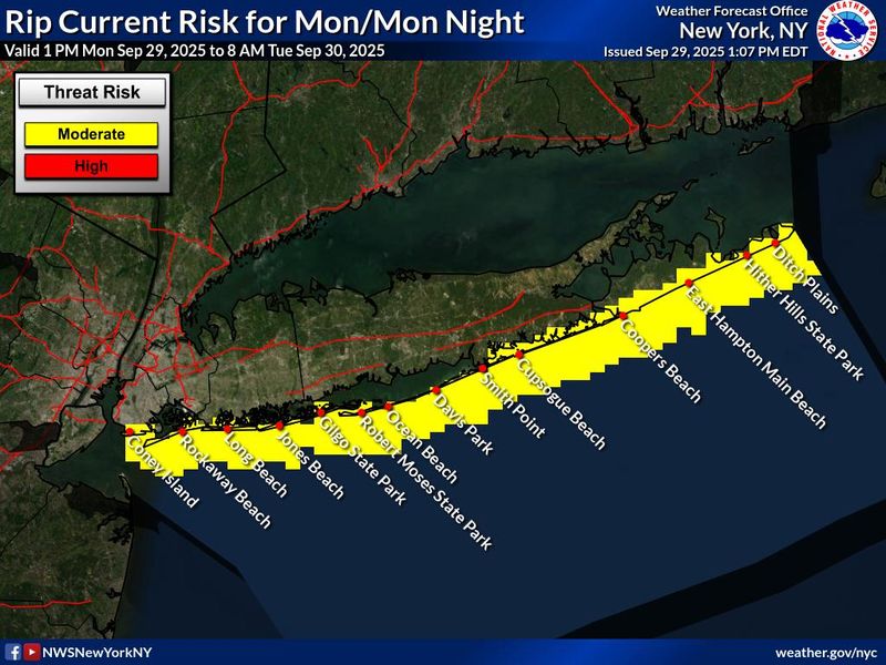
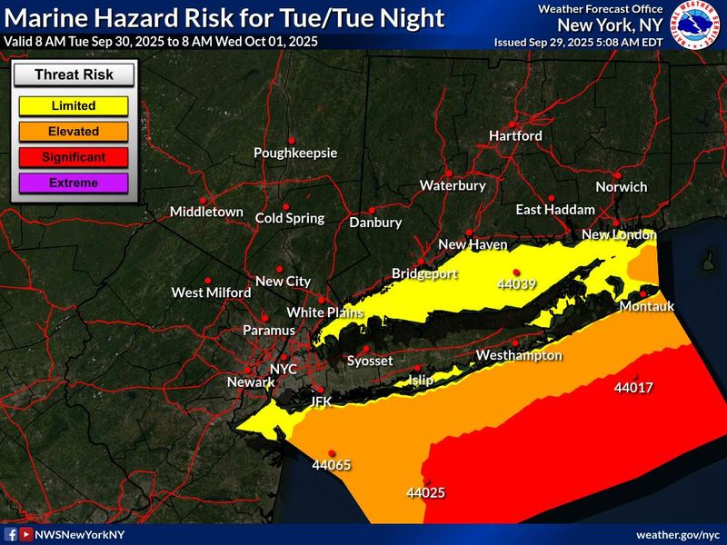
The NWS released two separate forecast hazard maps Monday that illustrate what New Yorkers can expect from heightened activity in the Atlantic due to both storms.
Beaches along the Atlantic coast in New York City and on Long Island can expect a moderate risk of rip currents. On Tuesday, Long Island Sound Shore communities in Westchester and coastal Connecticut may see a limited risk of marine hazards, such as “winds up to 15 knots and/or waves up to 2 feet,” the NWS said.
There’s an elevated risk of winds up to 25 knots and waves up to 5 feet on the Atlantic coast in New York City and on Long Island. Further out into the ocean sees a significantly higher risk, with potential for winds up to 34 knots and waves up to 10 feet high.
Imelda is closer to the mainland U.S., currently about 265 miles off the shore of Cape Canaveral with sustained winds of about 50 mph.
The National Hurricane Center projects that the storm will turn away from the mainland and towards Hurricane Humberto thanks to the push of a “high pressure system” over the northeast, USA TODAY says.
While the U.S. is not at risk of current devastation due to winds and rains, some parts of the Southeastern coast like North Carolina’s Outer Banks, some parts of South Carolina and Florida are under flood warnings and coastal rip tide watches.
This article originally appeared on Rockland/Westchester Journal News: Here’s how Hurricane Humberto, Tropical Storm Imelda could impact the East Coast
Reporting by Alexandra Rivera, Rockland/Westchester Journal News / Rockland/Westchester Journal News
USA TODAY Network via Reuters Connect