An Arctic blast is set to grip Iowa later this week, bringing some of the coldest temperatures of the season along with dangerous wind chills after a round of snow and gusty winds midweek.
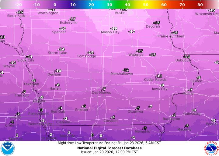
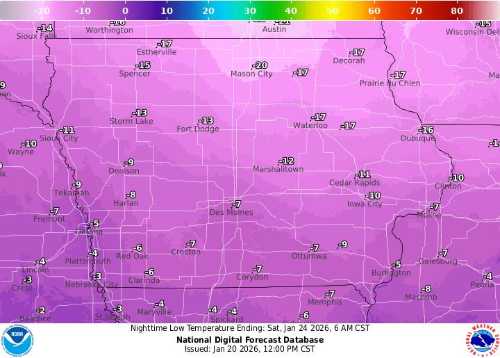
The coldest air arrives after a strong cold front moves through the state Thursday, Jan. 22. By Friday morning, Jan. 23, temperatures will fall below zero statewide, with some northern and northeastern communities approaching 20 below. Subzero lows are expected again Saturday morning as Arctic high pressure settles over the Midwest.

“Very cold weather is forecast from late Thursday through Saturday,” the National Weather Service office in Des Moines wrote. “Low temperatures both Friday morning and Saturday morning will be below zero statewide, and approach -20 degrees in some northern and northeastern areas. Dangerous wind chills may result.”
Will it snow in Iowa?
Before the deep freeze, parts of Iowa will see accumulating snow Tuesday afternoon into tonight, Jan. 20-21, according to the National Weather Service.
The highest confidence for several inches is across northern and northeastern Iowa, where a Winter Weather Advisory is in effect from midafternoon through late tonight for areas including Algona, Mason City and Waterloo. Snow is expected to develop during the afternoon and intensify into the evening, likely affecting the evening commute with slick and snow-covered roads.
Farther south, snow chances drop off, though lighter accumulations are possible as a secondary snow band sweeps through tonight, the National Weather Service said. Winds will be relatively light during the snowfall, limiting blowing snow for now, but travel impacts are still expected in advisory areas.
Another system follows quickly on Wednesday, Jan. 21. A second front will move through Iowa during the afternoon, bringing strong and gusty northwest winds, scattered snow showers and areas of blowing snow — especially where snow falls Tuesday night. Wind gusts could become strong enough to reduce visibility at times, and hazardous travel conditions may redevelop Wednesday afternoon and evening.
Once that system exits Wednesday night, precipitation chances decrease, but the weather turns increasingly harsh.
“Significant winter storm expected from the Southern Plains to the Mid-Atlantic bringing widespread heavy snow and ice impacts,” according to the Weather Prediction Center.
Record cold potential in Iowa. When the coldest air arrives
Arctic air pours into Iowa behind a cold front Thursday, Jan. 22. Temperatures will fall steadily through the day and into Thursday night, setting the stage for the coldest stretch of the week.
Friday and Saturday mornings are expected to be the coldest, with lows below zero across the entire state. Northern and northeastern Iowa could see temperatures nearing minus 20 degrees, while the southwest may stay closer to zero.
Daytime temperatures will struggle to recover. Highs Friday are forecast to range from the single digits above zero in southwestern Iowa to near 10 below in the northeast.
“Dangerously cold temperatures are forecast to impact the north- central U.S. starting Thursday under an arctic surface high, which will push much colder than average temperatures farther south and east for Friday into the weekend,” the Weather Prediction Center wrote. “The Northern Plains to Upper Midwest can expect extreme cold, with temperatures likely reaching 20 to 30 degrees below zero by Friday and Saturday morning, and even colder wind chills potentially reaching negative 50 degrees in some locations. Even highs are forecast to stay below zero degrees through Saturday in the Upper Midwest. Much colder than average temperatures will expand into the Central Plains Friday and towards the Gulf and East Coasts this weekend.”
Iowa weather watches and warnings
Here are the watches and warnings for the area.
Stay informed. Get weather alerts via text.
Brandi D. Addison covers weather across the United States as the Weather Connect Reporter for the USA TODAY Network. She can be reached at baddison@gannett.com. Find her on Facebook at facebook.com/BrandiAddisonNews.
This article originally appeared on Des Moines Register: Arctic blast headed for Iowa. How cold will it get? See maps
Reporting by Brandi D. Addison, USA TODAY NETWORK / Des Moines Register
USA TODAY Network via Reuters Connect