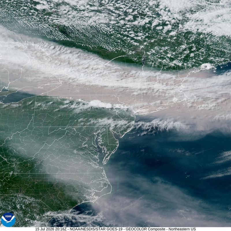
EVANSVILLE — Smoke from wildfires burning across northwestern Ontario has blanketed much of the Midwest for days, triggering air quality alerts from Minnesota to Michigan and prompting Indianapolis to issue its own pollution warning Friday.
Southwest Indiana, so far, has stayed in the clear.

That’s not luck so much as it is geography and timing, according to Mark Derf, section chief of the Technical Support and Modeling section at the Indiana Department of Environmental Management (IDEM). In an interview Friday, Derf said a frontal boundary has been holding the thickest smoke to the north, keeping it from reaching Evansville even as more northern parts of the state logged some of the worst air quality readings in the country this week.
“We expect Southwest Indiana should remain clear of smoke for the next couple of days,” Derf said.
Why the smoke hasn’t reached Evansville (yet)
IDEM issued an Air Quality Action Day for Thursday and Friday covering northern, north-central and northeastern Indiana, warning that fine particulate pollution, or PM2.5, could reach the “Very Unhealthy” range, the second-highest tier on the federal Air Quality Index. Vanderburgh County was not included in either advisory.
You can
The reason, Derf said, is a matter of wind direction and atmospheric pressure. A ridge of high pressure over the central United States has been steering northerly and northwesterly winds through the Canadian fires’ smoke plumes, pulling them south along the Great Lakes rather than directly toward Southwest Indiana. IDEM forecasters, he said, expect that pattern to hold before shifting.
The timeline: What’s coming this week
According to the National Weather Service’s Paducah forecast office, which covers the Evansville area, that shift could now be taking shape. A weak frontal boundary is expected to move through the region Sunday, followed by a cold front Tuesday that forecasters say could bring damaging winds and large hail to Southwest Indiana — a weather threat separate from, and more immediate than, any Canadian smoke.
The smoke risk, meanwhile, has shifted later and broader than initially expected. Derf said Friday that the heaviest statewide smoke impacts were likely Sunday into Monday. But the National Weather Service’s most recent forecast discussion, issued Saturday evening, tightened that outlook: any unhealthy air Sunday was now expected to be moderate and confined to the far north of the region, not statewide. Instead, forecasters wrote, wildfire smoke “may become more widespread across the Quad State toward the middle to end of next week,” as winds turn north.
The weather service pointed to Wednesday through Friday as the window most likely to bring smoke into the Tri-State.
Derf cautioned that any timeline remains uncertain days out.
“It’s a little too early to tell,” he said of any smoke impacts across the Evansville area, though he added that once smoke settles into a region, “it’ll kind of remain in place.”
How an Air Quality Action Day gets called
IDEM issues an Air Quality Action Day when its forecasters expect ozone or fine particulate pollution to cross into unhealthy territory — a call based on weather models, monitoring data and, in this case, the trajectory of the wildfires themselves. Derf said the goal isn’t just to warn residents, but to get them to reduce their own outdoor exposure and, where possible, cut emissions that make ozone pollution worse.
“We really just want people to reduce their exposure to outdoor air so they’re not exposed to that smoke,” Derf said, adding that children, older adults and people with asthma, lung disease or heart conditions face the greatest risk.
Hazy skies don’t always mean unhealthy air
Even if smoke becomes visible over Evansville, that alone won’t mean the air is dangerous to breathe. Aaron Updike, a National Weather Service meteorologist in Indianapolis, told IndyStar this week that an earlier wave of smoke sat too high in the atmosphere to meaningfully affect air quality there, producing hazy skies and vivid sunsets with little ground-level health impact. IDEM’s monitors and sensors — not the appearance of the sky — determine whether conditions have actually worsened, Derf said.
What to watch for and how to prepare
IDEM’s SmogWatch website publishes daily forecasts, current monitor readings statewide and sign-up alerts for email and text notifications whenever an Air Quality Action Day is called anywhere in Indiana. Derf recommended checking it regularly through the weekend.
If smoke does arrive, the guidance is familiar from prior wildfire and ozone alerts: limit time outdoors, keep windows closed, and run air conditioning on recirculate rather than pulling in outside air. N95 masks can filter out some of the smoke’s finer particles, Derf said, though he stopped short of recommending them as a reliable substitute for staying indoors.
The fires themselves show no sign of easing soon. Hundreds remain active across Canada, including dozens burning out of control in northwestern Ontario, and the smoke crossing into the U.S. this month has become its own point of friction between Washington and Ottawa, with President Donald Trump threatening new tariffs over what he called Canada’s “willful negligence,” according to CBC News. For now, though, the more immediate question for Evansville is narrower: whether a shift in the wind sends that smoke south before the week is out.
Houston Harwood may be contacted with questions and feedback at houston.harwood@courierpress.com
This article originally appeared on Evansville Courier & Press: Wind pattern keeping Canada fire smoke out of Evansville — for now
Reporting by Houston Harwood, Evansville Courier & Press / Evansville Courier & Press
USA TODAY Network via Reuters Connect
By Houston Harwood, Evansville Courier & Press | USA TODAY Network