The National Hurricane Center is tracking Invest 93L, which could become a tropical depression soon.
The area of low pressure was located just offshore the east coast of Florida early July 15 and was becoming better organized, according to forecasters.

➤ Track all active storms
➤ Weather alerts via text: Sign up to get updates about current storms and weather events by location
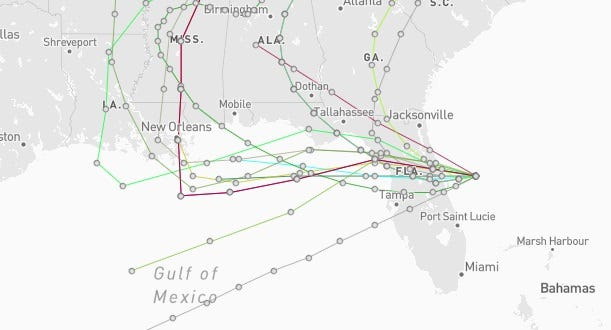
The system is expected to move west into the Gulf July 15, entering the Gulf by late tonight or early July 16.
➤ Track Invest 93L :
Spaghetti models for Invest 93L. See expected path
Special note about spaghetti models: Spaghetti model illustrations include an array of forecast tools and models, and not all are created equal. The Hurricane Center uses only the top four or five highest performing models to help make its forecasts.
How will the Invest 93L storm impact Jacksonville?
Even if the system doesn’t strengthen into a tropical depression or storm, the National Weather Service and National Hurricane Center warn that increased potential for locally heavy rainfall — especially along the I-75 corridor — could bring localized flash flooding to portions of Florida, including Jacksonville, through mid-week
The next named storm of the 2025 Atlantic hurricane season will be Dexter.
NWS Jacksonville weather radar shows path of storms associated with Invest 93L
Track active Atlantic storms and disturbances
This auto-updated graphic shows a map of all active storms in the Atlantic basin.
Can’t see the graphic? Open in a new browser.
NWS weather radar shows path, storms associated with Invest 93L
Latest weather watches and warnings issued in Florida
See the latest graphics, radar images on Invest 93L
Stay informed. Get weather alerts via text
What’s next?
We will update our tropical weather coverage daily.
Download your local site’s app to ensure you’re always connected to the news. And look for our special subscription offers here.
This article originally appeared on Florida Times-Union: Where is Invest 93L going? Spaghetti models, its path and possible Jacksonville impacts.
Reporting by Doris Alvarez Cea and Cheryl McCloud, Jacksonville Florida Times-Union / Florida Times-Union
USA TODAY Network via Reuters Connect