It’s official: The polar vortex has been getting the headlines for the frigid blasts of air shooting down from Canada to Florida the last few weeks, but La Niña is here for the winter.
Federal scientists from the National Oceanic and Atmospheric Administration’s Climate Prediction Center (CPC) confirmed that the La Niña weather pattern, which started in October, is expected to continue shaping U.S. weather through winter 2025-2026, according to a monthly update released Thursday, Dec. 11.

La Niña is a part of a natural climate cycle officially known as El Niño-Southern Oscillation, what scientists call ENSO. The cycle swings between warmer and cooler seawater in a region along the equator in the tropical Pacific Ocean.
La Niña and the polar vortex have already been interacting. The polar vortex often determines how much cold air makes it south and La Niña steers that air where she wants.
Another blast is expected next week, bringing frigid blasts to North and Central Florida on Sunday night and Monday morning.
After that, the vortex may back off and let a more typical La-Niña-like pattern take over, at least for the end of December and into January, forecasters said.
What is La Niña?
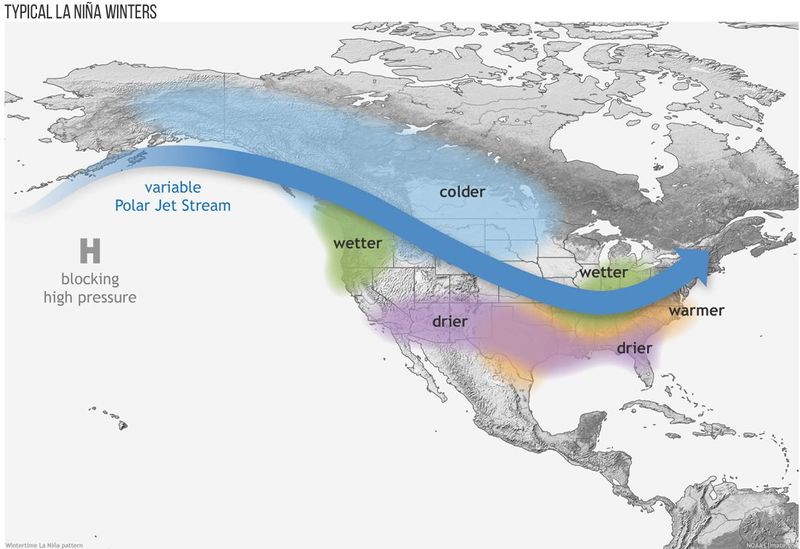
La Niña is a cooler-than-usual pulse of surface water in the Pacific Ocean, near the equator. It creates prevailing winds across the country that usually result in drier, warmer weather.
It’s part of a natural climate cycle officially known as El Niño-Southern Oscillation, called ENSO by scientists. La Niña, which is marked by cooler-than-average ocean water in the region, is the opposite of the more well-known El Niño, which occurs when Pacific Ocean water is at least 0.9 degrees warmer than average for three months.
The intermediate stage is known as ENSO-Neutral, when neither La Niña nor El Niño are present. The current La Niña is expected to transition into ENSO-neutral sometime between January and March 2026, forecasters said last month.
Will Florida get cold this winter?
Cold snaps aside, Florida is expected to see warmer-than-usual winter this year, according to long-range forecasts from the National Weather Service.
The NWS Climate Prediction Center said at the end of November that temps for December-January-February look to be above-normal across much of the East Coast, Southeast, Gulf Coast, Texas, the Southwest, and California.
Is El Niño next?
“At this point it’s simply too soon to say,” L’Heureux said. “There are growing chances of El Niño in mid-late 2026, but the chances remain less than 50%, which reflects the larger uncertainty we typically see as these forecasts go through the ‘spring predictability barrier.'”
That barrier is when the weather models have a harder time making accurate seasonal forecasts.
If El Niño did develop, it could act to suppress hurricane activity in the Atlantic basin next year.
Will La Niña increase fire dangers?
With much of North Florida stuck in an ongoing drought with frequent Red Flag warnings for fire danger due to low humidity, an abundance of dry fuel and warming conditions, this is something to keep an eye on.
In January, conditions similar to La Niña prevented rain and storms from reaching Southern California where Santa Ana winds fueled five different wildfires. They included the raging infernos that engulfed whole neighborhoods in Los Angeles County.
Thirty years ago in Florida, an abrupt switch from a soggy El Niño winter (which encouraged widespread growth of underbrush and vegetation) to a dry La Niña spring (which dried out all that new growth) led to the Florida Firestorm, when a large part of the state was in daily flames for weeks.
More than 10,000 firefighters helped battle 2,200 wildfires across Florida, which raged for a month and a half, damaged or destroyed 337 homes and 33 businesses and burned well over half a million acres. Some major highways were intermittently blocked off and thousands were evacuated, including the entirety of Flagler County, about 40,000 people although, amazingly, no one died.
La Niña tends to yield temperatures 1 to 3 degrees above normal and rainfall 10% to 30% below normal.
When does winter begin?
Which one?
Meteorological winter, part of a system that breaks seasons into 3-month periods for easier year-over-year comparisons, starts on Monday, Dec. 1 this year.
Astronomical winter is based on the actual movement of the earth and sun. There, winter begins on the solstice, which occurs at 10:03 a.m. ET on Sunday, Dec. 21.
Stay informed. Get weather alerts via text
What’s next?
We will provide weather coverage as conditions warrant to keep you informed.
Download your local site’s app to ensure you’re always connected to the news. And look for our special subscription offers here.
This article originally appeared on Tallahassee Democrat: What is La Niña? It’s here for the winter. What it means for Florida
Reporting by C. A. Bridges and Doyle Rice, USA TODAY NETWORK – Florida / Tallahassee Democrat
USA TODAY Network via Reuters Connect