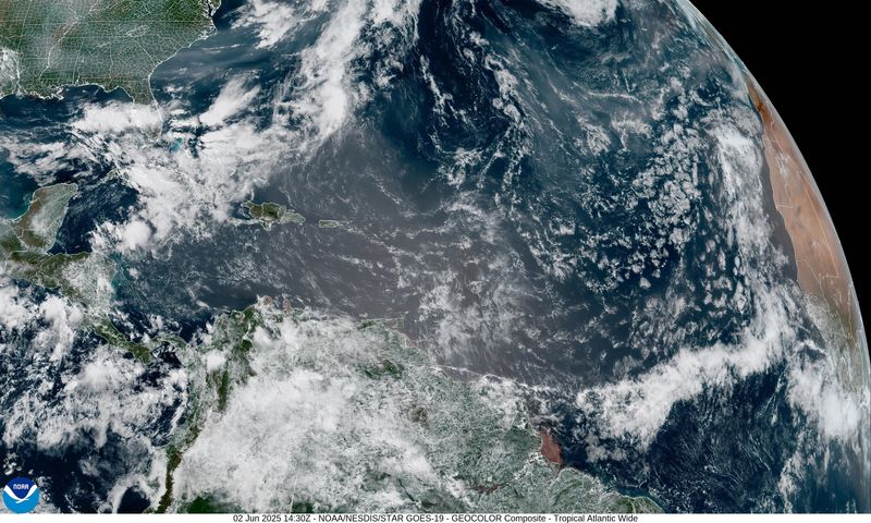
A “wall of dust” is heading toward Florida and could hang around until the weekend.
Saharan dust helps prevent hurricanes from developing or strengthening and provides some vivid sunrises and sunsets.

➤ Weather alerts via text: Sign up to get updates about current storms and weather events by location
Saharan dust moving across the Atlantic from Africa isn’t unusual. Activity usually ramps up in mid-June, peaks from late June to mid-August, and begins to subside after mid-August.
Dust isn’t the only threat out there, especially for those with respiratory problems. Smoke from Canadian wildfires is moving south into the U.S., although it is not expected to last as long or be as bad in Florida as it was almost two years ago.
Here’s what you should know.
‘Wall of dust’ approaching Florida, US
“We’re currently seeing a massive plume of dust moving east through the Caribbean,” said Alex DaSilva, AccuWeather lead hurricane expert, said in an email Monday afternoon.
“It’s about 2,000 miles wide from east to west, stretching from Jamaica all the way past Barbados. North to south, it’s about 750 miles, spanning from Trinidad and Tobago in the south to north of Puerto Rico.
“That gives you a sense of the scale; it’s essentially a wall of dust. While it’s not uncommon for dust to cross the Atlantic, this is one of the larger plumes we’ve seen so far this season. It’s not necessarily unusual, but definitely on the stronger side.”
“We expect it to arrive in the U.S. late in the week. Florida could see enhanced sunsets as early as Thursday, and the dust could spread into parts of the northern Gulf Coast — places like Houston, New Orleans, and Baton Rouge — by Friday into Saturday,” DaSilva said.
“While it’s not rare for this dust to travel across the Atlantic and affect the southern U.S., it usually only happens a couple of times a year. This appears to be the largest plume we’ve seen in 2025 so far.”
“It’s an expansive plume, something that is typical for this time of year,” said Fox Weather meteorologist Bob Van Dillen said via email Monday.
“It doesn’t look as deep of a layer as the models had predicted last week, but it’s still should be enough for Floridians to notice a haze in the air. Sunrises and sets should feature more of a darker red hue as well, stating Wednesday and peaking Friday/Saturday. The heaviest concentration of dust looks like Central Florida at this point. This will be the biggest push of Saharan dust into Florida so far this year.”
What can Florida expect from Saharan dust this week?
Since most of the dust typically is high in the atmosphere, “it rarely causes significant air quality issues for breathing,” DaSilva said. “If the dust is really thick, it can impact surface air quality, but that’s uncommon.
“Interestingly, rain showers are expected (this week) as well. When that happens, the dust can get caught in raindrops and settle on the ground. Once it dries, it might leave a residue — brown dust on cars.”
Phone lines at the National Weather Service office in Mobile are down. We’ve reached out via email and will update this story once we hear from them.
Will smoke from Canadian wildfires reach Florida?
The same weather conditions bringing the Saharan dust into Florida is helping push smoke from the Canadian wildfires away from the Sunshine State.
“The Canadian wildfire smoke is definitely into north central Florida and the Panhandle,” Van Dillen said.
“All the storms Monday afternoon in South Florida has essentially ‘washed’ it out of the air, no worries there for smoke. It looks like the smoke hangs out through Tuesday morning until it rushes north and out; that wind shift will actually usher in the Saharan dust.
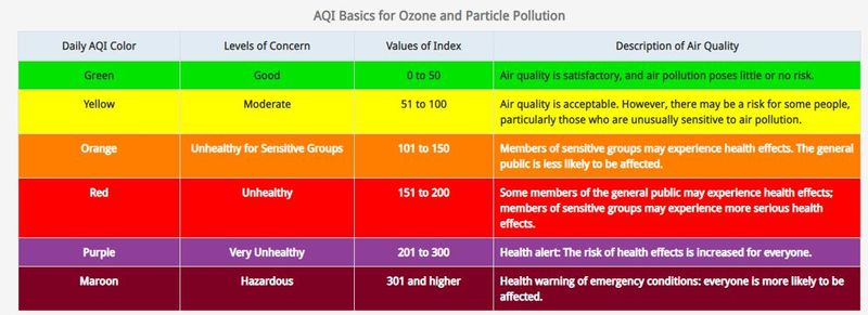
“Smoke is noticeable in north Florida now (late Monday, June 2) but not as thick as neighbors to the north in Georgia and South Carolina. Air quality alerts were posted for the poor air resulting from the smoke and ozone combining from the warm air.”
What is Saharan dust?
Known officially as the Saharan Air Layer, Saharan dust is dry, dusty air that forms over the Sahara Desert in northern Africa, according to the National Weather Service.
As it moves off the west coast of Africa, it can travel across the North Atlantic reaching Florida and the United States.
The Saharan Air Layer can be 2 to 2.5 miles thick, starting about one mile above the surface.
➤ Interactive map: Check air quality in Brevard County
When does Saharan Air Layer normally occur?
The Saharan Air Layer forms over the Sahara Desert during late spring, summer, and early fall, moving over the tropical North Atlantic every three to five days, the National Weather Service said.
Activity usually ramps up in mid-June, peaks from late June to mid-August, and begins to rapidly subside after mid-August.
“During the peak period, individual Saharan Air Layer outbreaks reach farther to the west — as far west as Florida, Central America and even Texas — and cover vast areas of the Atlantic.”
How does Saharan dust affect tropical storms and hurricanes?
Three factors associated with Saharan dust help prevent tropical cyclones from developing and, with storms already present, inhibit strengthening:
Saharan dust brings vivid sunrises, sunsets
While Saharan dust can make the sky look hazy it can bring some stunning sunrises and sunsets.
Where there is a lot of dust — or smoke — in the atmosphere, sunrises and sunsets can appear even more yellow, orange and red than normal, according to the National Weather Service.
“A heavy load of dust in the atmosphere can enhance … leads to longer-lasting, duskier colors that cause vivid sunsets and sunrises.”
Air quality from dust, smoke could pose respiratory problems for some
“Saharan dust lowers air quality by increasing the concentration of mineral dust, things like silica and quartz,” Dr. Samuel Gurevich, a pulmonologist with Cleveland Clinic in Florida said in an email.
“These tiny particles can travel deep into the lungs and cause significant inflammation.”
The dust also tends to make the air drier, which can further irritate airways, Gurevich said. This might mean a runny nose or itchy eyes.
“But, for people with respiratory conditions, it can cause more serious symptoms or flare ups,” he said.
How is the air quality in Florida? How can you check local conditions?
Can’t see the map?
What are air quality alerts?
Air quality alerts are indicators the air is unsafe to breathe for certain people. Alerts are triggered by a number of factors, including the detection of fine-particle pollution, which can irritate the lungs.
Stay informed. Get weather alerts via text
What’s next?
We will provide tropical weather coverage daily until Nov. 30 to keep you informed and prepared. Download your local site’s app to ensure you’re always connected to the news. And look for our special subscription offers here.
This article originally appeared on Palm Beach Post: ‘Wall of dust’: See impacts of Saharan dust, smoke from Canadian wildfires in Florida
Reporting by Cheryl McCloud, USA TODAY NETWORK – Florida / Palm Beach Post
USA TODAY Network via Reuters Connect