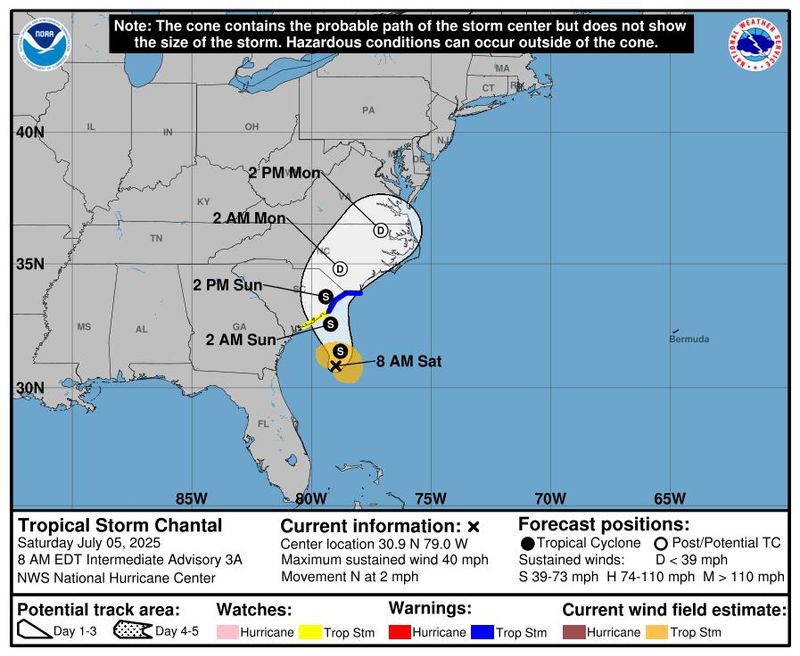
Tropical Depression 3 strengthened into Tropical Storm Chantal on Saturday, July 5, according to the latest update from the National Hurricane Center.
At 8 a.m., Tropical Storm Chantal was located about 150 miles south-southeast of Charleston, South Carolina, with maximum sustained winds of 40 mph.

Chantal is moving north at 2 mph. A slow motion north-northwest is expected to begin later today, followed by a turn to the northeast by Sunday night.
Forecasters expect the center of Chantal to move near or over the coast of South Carolina on Sunday morning.
A tropical storm warning is in effect for South Santee River, South Carolina to Cape Fear, North Carolina. A tropical storm watch was issued for Edisto Beach to South Santee River, South Carolina.
➤ Weather alerts via text: Sign up to get updates about current storms and weather events by location
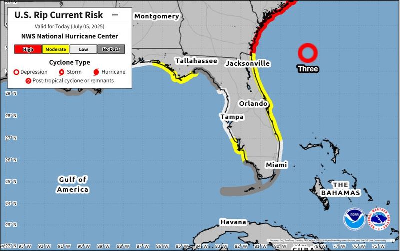
Chantal is expected to bring showers and thunderstorms along Florida’s east coast, as well as rough surf and dangerous rip currents, per the National Weather Service.
“Seas and surf will build from the Florida Atlantic coast to the North Carolina Outer Banks during the extended Independence Day weekend,” AccuWeather reported.
Here’s the latest advisory from the National Hurricane Center as of 8 a.m. on July 5.
Where is Tropical Storm Chantal now?
At 8:00 a.m., the center of Tropical Storm Chantal was located near latitude 30.9 North, longitude 79.0 West.
The storm is moving slowly toward the north near 2 mph.
A slow motion toward the north-northwest is expected to begin later today, followed by a turn to the northeast by Sunday night.
On the forecast track, the center of Chantal is expected to move across the coast of South Carolina Sunday morning.
Maximum sustained winds have increased to near 40 mph with higher gusts. Some additional strengthening is expected before Chantal reaches the coast.
Tropical-storm-force winds extend outward up to 70 miles primarily to the east of the center.
Watches and warnings for Tropical Storm Chantal
A Tropical Storm Warning means that tropical storm conditions are expected somewhere within the warning area, in this case within the next 12 to 24 hours.
A Tropical Storm Watch means that tropical storm conditions are possible within the watch area, generally within 48 hours.
Interests elsewhere along the southeast coast of the United States should monitor the progress of this system. Additional warnings and watches will likely be required for portions of this area later today.
Key messages for Tropical Storm Chantal
Tropical Storm Chantal hazards affecting land
WIND: Tropical storm conditions are expected in the warning area beginning this evening and continuing into Sunday morning. Tropical storm conditions are possible in the watch area beginning later today.
RAINFALL: Tropical Storm Chantal is expected to produce heavy rainfall across portions of the coastal plain of the Carolinas today through Monday. Storm total rainfall of 2 to 4 inches, with local amounts to 6 inches, is expected. Resulting in an elevated risk for flash flooding. For a complete depiction of forecast rainfall and flash flooding associated with Tropical Storm Chantal, please see the National Weather Service Storm Total Rainfall Graphic, available at hurricanes.gov/graphics_at3.shtml?rainqpf
STORM SURGE: The combination of storm surge and tide will cause normally dry areas near the coast to be flooded by rising waters moving inland from the shoreline. The water could reach the following heights above ground somewhere in the indicated areas if the peak surge occurs at the time of high tide.
SURF: The tropical storm is expected to bring life-threatening surf and rip currents along the coast from northeastern Florida to the Mid-Atlantic states during the next couple of days.
Tropical Storm Chantal spaghetti models
Special note about spaghetti models: Spaghetti model illustrations include an array of forecast tools and models, and not all are created equal. The Hurricane Center uses only the top four or five highest performing models to help make its forecasts.
Track active Atlantic storms and disturbances
This auto-updated graphic shows a map of all active storms in the Atlantic.
If the storm trackers are not loading, click here.
NWS radar for Florida, July 5, 2025
Florida rip current map for June 22, 2025
Among the changes the National Hurricane Center announced for the 2025 hurricane season was the addition of a rip current risk map.
➤ National Hurricane Center lays out changes coming for 2025 season. See what to expect
This new addition provided by the Hurricane Center will be provided for the current day, the next day, and as a composite showing the highest risk over both days for areas along the East and Gulf coasts of the United States, Puerto Rico and the U.S. Virgin Islands, and the coast of southern California.
➤ Florida ranks in top 5 states where swimming is most dangerous. How to avoid summer tragedy
Weather watches and warnings issued in Florida
When is the 2025 Atlantic hurricane season?
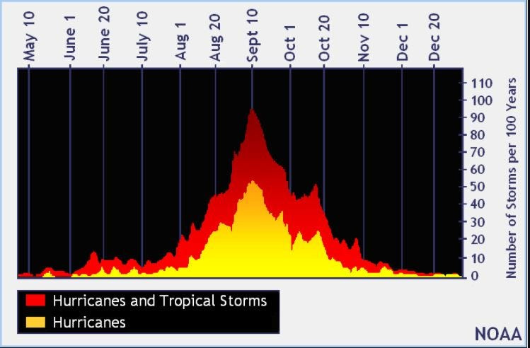
The Atlantic hurricane season runs from June 1 through Nov. 30.
Ninety-seven percent of tropical cyclone activity occurs during this time period, NOAA said.
The Atlantic basin includes the northern Atlantic Ocean, Caribbean Sea and Gulf of America, as the Gulf of Mexico is now known in the U.S. per an order from President Trump. NOAA and the National Hurricane Center are now using Gulf of America on its maps and in its advisories.
When does hurricane season start? When is the peak?
The peak of the season is Sept. 10, with the most activity happening between mid-August and mid-October, according to the Hurricane Center. Hurricane season starts June 1 in the Atlantic basin.
Interactive map: Hurricanes, tropical storms that have passed near your city
Stay informed. Get weather alerts via text
What’s next?
We will update our tropical weather coverage daily.
Download your local site’s app to ensure you’re always connected to the news. And look for our special subscription offers here.
This article originally appeared on Naples Daily News: Tropical Storm Chantal forms. Florida rain, storms, South Carolina landfall expected
Reporting by Kim Luciani and Cheryl McCloud, USA TODAY NETWORK – Florida / Naples Daily News
USA TODAY Network via Reuters Connect