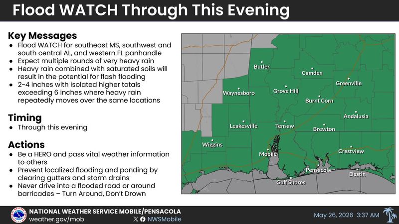
The National Weather Service office in Mobile, Alabama, has issued a flood watch for the Florida Panhandle, as multiple rounds of heavy rain are forecast to pass over the area through the evening. It will remain in effect through Tuesday evening.
NWS forecasters say that 2 to 4 inches of additional rainfall is expected, with locally higher amounts exceeding 6 inches through Tuesday evening. The Gulf-led storms will also create dangerous rip currents across Florida Panhandle beaches.

That much rain on top of Monday’s downpours could lead to excessive runoff, resulting in flooding rivers, creeks, streams and other low-lying and flood-prone areas, according to the NWS. Flooding may also occur in poor drainage and urban areas, or around areas where storm drains and ditches become clogged with debris.
The latest guidance is starting to hone in on a corridor of more substantial rainfall across south central Alabama into the Florida Panhandle. That area, which includes northern Escambia and Santa Rosa counties, could see as much as 6 inches of rain.
“If storms sit and train over the same areas, local totals could be much higher, potentially exceeding 10 inches,” the NWS said in its latest forecast discussion.
Pensacola weather forecast for Tuesday, May 26
Similar to Monday’s storms, Pensacola is expected to have a quieter early morning, which will be disrupted by rounds of showers and storms developing by mid-to-late morning.
The NWS’ hourly forecast shows the highest chances of rain occurring between 11 a.m. and 7 p.m. on Tuesday, with steady rainfall happening overnight.
Storms are expected to start near the coast, hitting the Panhandle first before spreading inland. Flooding will be the biggest threat associated with inbound storms throughout the week as additional rainfall triggers the chances of flooding.
Pensacola weather forecast through the week
Don’t expect the weather pattern to change much as the week progresses. The NWS says that multiple subtle upper-level disturbances, called shortwaves, will pass over the area throughout the week, triggering the development of showers and storms daily.
NWS expects multiple rounds of storms capable of producing very heavy rainfall, which it says could lead to flash flooding this week. The potential for flooding will depend on how much rainfall a particular area gets.
This week’s storms will be capable of producting 1 to 2 inches of rain in a short period of time, according to the NWS.
The Pensacola International Airport reported just over an inch of rain over the past 24 hours. Whiting Field Naval Air Station reported nearly 1.5 inches of rain over the same period.
Pensacola weather radar
Pensacola severe weather warnings, watches and alerts
This article originally appeared on Pensacola News Journal: Threats of downpours trigger flood watch in Pensacola area
Reporting by Brandon Girod, Pensacola News Journal / Pensacola News Journal
USA TODAY Network via Reuters Connect