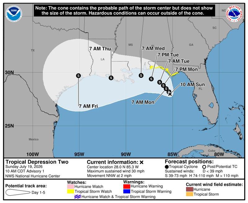
A storm system in the northeastern Gulf has become better organized and is now a tropical depression, forecasters say, sparking alerts about days of heavy rain and localized flooding across North Florida and the Big Bend.
The storm is forecast to strengthen into Tropical Storm Bertha after the National Hurricane Center increased development odds to 80% Sunday morning.

Tallahassee-area forecasters emphasized that flooding rain — not wind — remains the region’s primary threat at this time. Still Tropical Storm Watches for winds between 39-73 mph have been hoisted for coastal Florida from Ochlockonee River to the Alabama border. The watch area covers coastal areas of Franklin, Gulf, Bay, Walton, Okaloosa, Santa Rosa and Escambia counties.
While computer models are split on exactly where the system that is southwest of Tallahassee will move, most forecast guidance keeps the broad circulation lingering in the northeastern Gulf before drifting westward early this week toward Louisiana and Texas.
Regardless of the eventual track, bands of tropical rain are expected to spread across the eastern Gulf Coast, including Tallahassee and surrounding counties.
“The area of low pressure located over the northeastern Gulf of America continues to become better defined and the associated shower and thunderstorm activity is gradually increasing,” the National Hurricane Center said in its Tropical Outlook Sunday morning.
The hurricane center warned that residents along the northern Gulf Coast should closely monitor the system’s development.
Meteorologist Ryan Truchelut, whose WeatherTiger firm crafts hurricane forecasts for the USA TODAY NETWORK, noted that Hurricane Hunter aircraft is flying missions into the depression.
Felicia Bowser, a meteorologist at the National Weather Service in Tallahassee, told the Tallahassee Democrat that the Tropical Storm watches are confined to coastal areas in north Florida. Inland areas in particular, such as Florida’s capital city, are likely to see “more of a glancing blow” from outer rain bands, while the coast could see heavier rains and rising seas.
A Tropical Storm Bertha or a depression would bring tropical rain bands to Tallahassee area
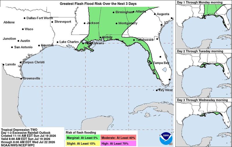
The National Weather Service in Tallahassee said the biggest concern remains flooding from repeated rounds of “quick tropical downpours.”
“It remains too early to determine specific impacts, although heavy rain appears likely in Florida along with gusty winds along the coast,” forecasters said in their morning forecast discussion.
Rain bands could begin affecting the coast Sunday night before becoming more widespread Monday and Tuesday.
Forecasters said tropical moisture levels are expected to be unusually high, allowing storms to produce sudden intense downpours capable of overwhelming drainage systems and flooding low-lying areas.
“Our biggest impacts at the moment will continue to be rounds of tropical downpours, leading to some flood potential,” the Tallahassee forecast office said.
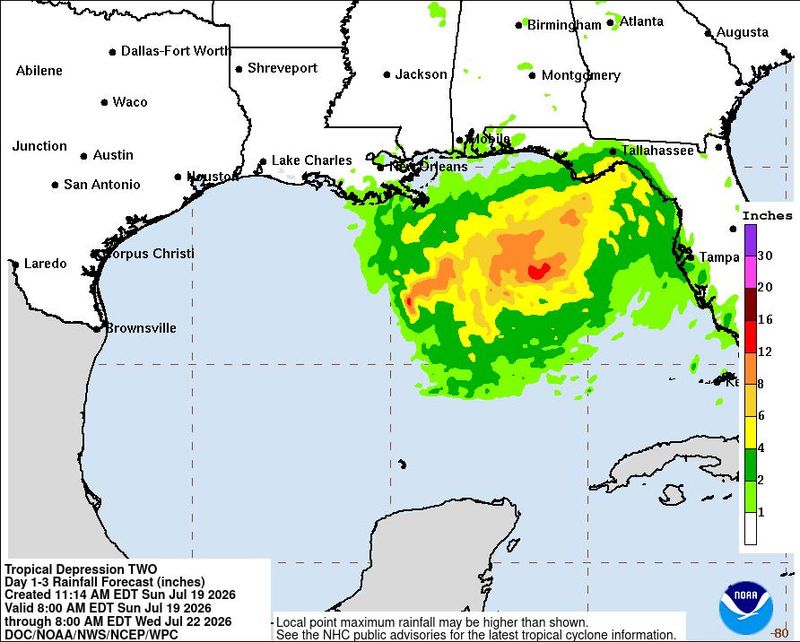
Those in the Florida Big Bend south of I-10 are forecast to pick up 2 to 4 inches, with locally higher amounts exceeding 6 inches possible, especially along the coast of Apalachee Bay from Indian Pass over to Suwannee.
All told, 1 to 3 inches of rain is forecast across much of the area outside of the Florida Big Bend.
Because of that, the Weather Prediction Center (WPC) maintains a Marginal Risk (Level 1 of 4) for Excessive Rainfall through at least Thursday morning.
Models shifting but remain mixed on storm’s ultimate destination
The latest model guidance shows continued uncertainty regarding the system’s future track.
Most model clusters suggest a westward drift toward Alabama, Mississippi or Louisiana later in the week. The spread in solutions reflects the fact that the system has not yet developed a well-defined center.
Forecasters caution that track forecasts often change significantly before a tropical cyclone fully forms.
“Models do an inherently poor job of predicting the track of these things before a singular closed surface low has actually formed,” Tallahassee meteorologists noted in Sunday’s forecast discussion.
Tallahassee area impacts at a glance
For the Tallahassee area, residents should prepare for:
This article originally appeared on Tallahassee Democrat: Tallahassee, Florida will see waves of rain as Gulf tropical depression forms
Reporting by William L. Hatfield, Tallahassee Democrat / Tallahassee Democrat
USA TODAY Network via Reuters Connect
By William L. Hatfield, Tallahassee Democrat | USA TODAY Network