PANAMA CITY — It’s been rainy in Bay County, with thunderstorms rolling through near-daily. It doesn’t appear that these conditions will let up in the near future, with significant rain chances extending through July 4.
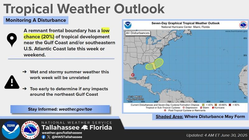
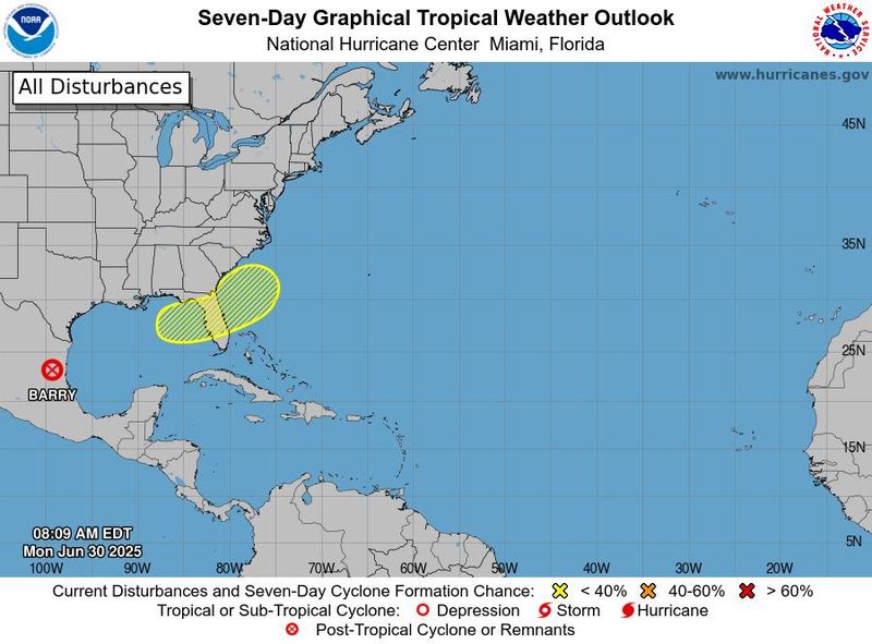
This comes as the National Hurricane Center tracks a disturbance hovering over the state. Meteorologists are giving the system a 20% chance of cyclone development over the next seven days. NWS Tallahassee said it’s too early to determine any impacts around the Northeast Gulf Coast, adding that the stormy summer weather this week is unrelated.

A NWS meteorologist said in the area’s forecast discussion that the consensus around the system is that tropical development is unlikely.
A stalled front is expected to dump rain on the region. The forecasting office says that two to three inches is anticipated through July 6.
“While the entire area has the potential to experience locally heavy rainfall and flooding, the best chances remain south of I-10 and especially along the coast,” according to the forecast discussion. “Several rounds of heavy rain spread out over several days could eventually lead to rainfall totals of 5 to 8+ inches with the best chances remaining near the coast.”
Daily thunderstorms and rain chances are forecast throughout the work week. July 1 has the highest chances with 90%. Precipitation chances drop to 50% on July 3. By Independence Day, meteorologists are looking at a 40% chance accompanied by possible thunderstorms.
Rains on July 4 should mainly be after 2 p.m. with sunny and hot daytime conditions. A high of 96 is expected.
“Coastal areas and particularly the southeast Big Bend will still have the potential to see additional rounds of heavy rainfall and a few inches of rainfall accumulation,” a meteorologist said in the July 3 through Independence Day forecast. “Therefore, some heavy rainfall and flooding threat will persist throughout the forecast period.”
On top of stormy conditions, AccuWeather anticipates feels-like temperatures above 100 after July 3 and into the next week.
The Climate Prediction Center anticipates above-average temperatures and precipitation over the next two weeks. The next three months share a similar outlook.
Yellow flags were flying over Panama City Beach on June 30. This indicates moderate surf and currents; swimmers should use caution. There’s a rip current statement in effect, advising of the potential for dangerous rip currents.
State Forecast
An approaching cold front could bring fireworks of its own to North Florida this Fourth of July weekend, though chances of tropical development remain low for now.
The National Hurricane Center in Miami is monitoring for the possible formation of a tropical or subtropical storm system across a broad area encompassing the eastern Gulf, much of the Florida peninsula and the Georgia and South Carolina coast.
David Reese, meteorologist with the National Weather Service in Tallahassee, said a cold front moving across the area will bring slightly drier conditions later this week, though that could change if a tropical system forms.
➤ Track all active storms
➤ Weather alerts via text: Sign up to get updates about current storms and weather events by location
“As that front kind of moves into the Southeastern U.S., it could slide into the northeastern Gulf or just off the east coast of Georgia and Florida,” Reese said. “And this time of year, if you see something like that happen, you always have to watch out for bigger storms that may try to get their act together and start spinning on us.”
The Hurricane Center, as of Monday, June 30, put chances of that happening at a modest 20%. However, those chances were up ever so slightly from the day before.
Reese said forecasters are being a little more proactive in messaging about the potential tropical activity because of the holiday.
“We are heading into the Fourth of July weekend,” he said. “Just because it’s that doesn’t mean you should take your eyes off the weather. Because if something does form … it could be here in the northeastern Gulf. And if it’s in the northeastern Gulf, we could really start to ramp up things in a hurry.”
Tallahassee otherwise has a 40% to 60% chance of rain on July 4, though Reese said any storms would likely wind down after sunset.
Forecasters say the city could see 3-4 inches of rain through next Sunday. Coastal areas could get 4-6 inches of rain.
Is a tropical storm or hurricane coming toward Florida?
A frontal boundary is expected to stall and weaken off the southeast U.S. coast late this week, according to the National Hurricane Center.
An area of low pressure could develop from the weakening front by the weekend off the southeast U.S., over Florida, or over the eastern Gulf.
Some gradual tropical or subtropical development could occur thereafter as the low moves little.
“A cold front will dive off the coast late this week, and it may act as a catalyst for development either in the eastern Gulf or off the Southeast coast,” said Alex DaSilva, AccuWeather lead hurricane expert.
“Wind shear, which can inhibit development, is expected to be fairly low and ocean water temperatures in the Gulf are above average which can aid in development in the outlooked area.”
Could tropical system impact Florida over holiday weekend?
“This system poses no direct threat to Florida over the next 5-7 days; however, this system could bring locally heavy rainfall, gusty winds and an increased rip current risk along the Gulf or Atlantic Coast later this week and will continue to be monitored closely,” the Florida Department of Emergency Management said.
“Those heading to the beaches for the holiday weekend from northern Florida and the Alabama and Mississippi panhandles to the Carolinas are urged to monitor the forecast, as there may be rough surf and rip currents and perhaps gusty winds should a tropical depression or storm develop,” DaSilva said.
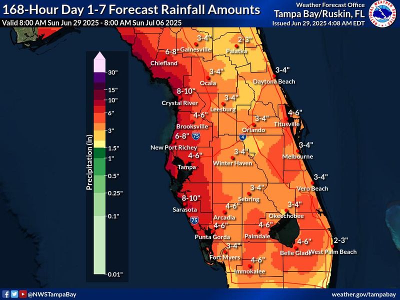
Heavy rainfall expected on Florida’s Gulf Coast over next seven days
Rain chances are increasing along Florida’s Gulf Coast for the next several days, with heavy rainfall contributing to flash flooding at times, according to the National Weather Service regional forecast offices.
Throughout the weather service’s Tallahassee region, daily rain chances are over 85 percent through Wednesday, July 2.
Predicted rainfall totals further south on the coast creep up into the double digits through the next seven days, with the heaviest rain expected Thursday, July 3 as the system the National Hurricane Center is watching moves over the state, the weather service office in Ruskin/Tampa Bay said Sunday morning.
Showers, thunderstorms could affect Fourth of July plans
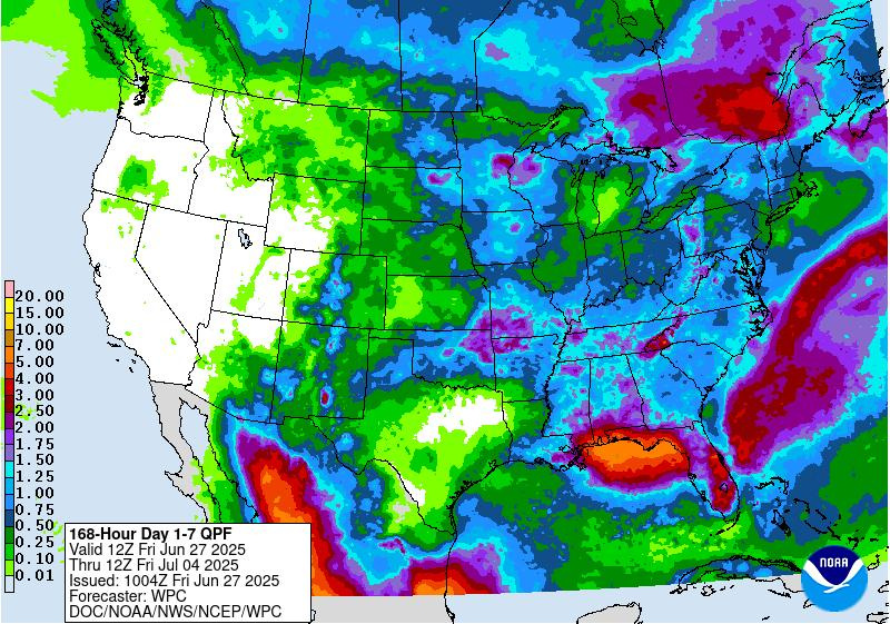
“We’re forecasting a wet pattern across the Southeast in early July, regardless of any tropical development,” DaSilva said.
“Much of Florida and the Southeast will see plenty of showers and thunderstorms during early July, and that could impact outdoor plans for the Fourth of July.
“Northern Florida and the Panhandle will see more rainfall than South Florida in early July.”
Is any Saharan dust approaching Florida?
“There is a big plume of dust coming across the Atlantic right now. We expect more Saharan dust to reach portions of the southern U.S. from South Florida to Texas.
“We could have some Saharan dust high in the sky for the Fourth of July, especially across South Florida.”
“We could see some dirty rain across Florida that can make a mess on your car and other surfaces outside, thanks to
This article originally appeared on The News Herald: Storms in the forecast for Bay County ahead of July 4. Is a tropical storm possible?
Reporting by Dylan Gentile, Jeff Burlew and Cheryl McCloud, USA TODAY NETWORK – Florida / The News Herald
USA TODAY Network via Reuters Connect