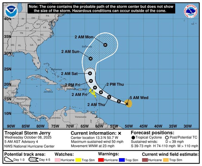
Tropical Storm Jerry is expected to strengthen and become a hurricane on Thursday, Oct. 9, according to the National Hurricane Center.
Tropical storm watches have been issued for portions of the northern Leeward Islands in the northeastern Caribbean Sea ahead of Jerry, which is expected to be near or to the north of the islands late Thursday and Friday.

So, what does this mean for Jacksonville? As of now, from the Central Atlantic Ocean, no direct impacts are expected in the Jacksonville area from Tropical Storm Jerry. And from the Southwestern Gulf, there is a low (10 percent) chance of tropical development through Thursday.
However, the National Weather Service is monitoring the development of a long-duration Nor’easter, expected to begin on Thursday. This system is forecast to remain strong and gusty through the weekend, and the impacts will be felt in the Jacksonville area.
Here’s what to expect for the rest of the weekend as we continue to monitor both Tropical Storm Jerry and the effects of the Nor’easter.
➤ Track Tropical Storm Jerry
➤ Weather alerts via text: Sign up to get updates about current storms and weather events by location
Minor tidal flooding continues through Wednesday evening
The National Weather Service has also issued a Coastal Flood Advisory, with minor tidal flooding expected along the Northeast FL coast, ICWW, and the rest of the St. Johns River Basin.
Long Nor’Easter develops Thursday in Jacksonville
Here are the local impacts, and what to expect according to the NWS:
NWS Jacksonville Radar
What’s the latest on Tropical Storm Jerry?
At 8 a.m., the National Hurricane Center said a NOAA hurricane hunter aircraft was investigating Jerry.
A dip in the jet stream is then expected to send Jerry on a path similar to other storms this season. Jerry is expected to curve north and then out to sea, staying away from Florida and the U.S., according to AccuWeather.
Highlights on what Tropical Storm Jerry is doing now
Special note on the NHC cone: The forecast track shows the most likely path of the center of the storm. It does not illustrate the full width of the storm or its impacts, and the center of the storm is likely to travel outside the cone up to 33% of the time.
Spaghetti models for Tropical Storm Jerry
Special note about spaghetti models: Illustrations include an array of forecast tools and models, and not all are created equal. The hurricane center uses only the top four or five highest performing models to help make its forecasts.
➤ Track Tropical Storm Jerry
See map of watches, warnings issued for Florida
No tropical storm or hurricane watches or warnings associated with Tropical Storm Jerry have been issued for Florida or the U.S.
How strong is Tropical Storm Jerry and where is it going?
At 8 a.m., the center of Tropical Storm Jerry was located near latitude 13.3 North, longitude 51.6 West.
Jerry is moving toward the west-northwest near 23 mph. This general motion is expected to continue with a decrease in forward speed during the next couple of days, followed by a turn toward the north-northwest and north beginning on Friday, Oct. 10.
On the forecast track, the core of the system is expected to be near or to the north of the northern Leeward Islands late Thursday and Friday.
Maximum sustained winds are near 50 mph, with higher gusts.
Strengthening is expected during the next few days, and Jerry is forecast to become a hurricane on Thursday, Oct. 9.
Tropical-storm-force winds extend outward up to 125 miles from the center.
The estimated minimum central pressure is 1003 mb.
Is there a hurricane coming toward Florida?
No. While Tropical Storm Jerry is expected to become a hurricane Thursday, Oct. 9, the storm is forecast to curve north, staying away from Florida and the U.S. east coast.
Watches, warnings associated with Tropical Storm Jerry
A tropical storm watch is in effect for:
A tropical storm watch is issued when a tropical cyclone containing winds of 39 to 73 mph or higher poses a possible threat, generally within 48 hours. These winds may be accompanied by storm surge, coastal flooding, and/or river flooding, according to the National Weather Service.
Key messages from the National Hurricane Center: What you need to know about Tropical Storm Jerry
Current forecast: Where is Tropical Storm Jerry going and how strong could it get?
What impact could Tropical Storm Jerry have and what areas could be affected?
Wind: Tropical storm conditions are possible in portions of the northern Leeward Islands within the watch area late Thursday into Friday.
Rainfall: On Thursday into early Friday, 2 to 4 inches of rain are expected across the Leeward Islands due to Jerry. This rainfall brings a risk of flash flooding, especially in areas of higher terrain.
Surf: Swells generated by Jerry are expected to reach the Leeward and Windward Islands on Thursday, then spread westward toward the Greater Antilles on Friday. These swells are likely to cause life-threatening surf and rip current conditions.
Interactive map: What tropical storms, hurricanes have impacted your area in the past?
Stay informed. Get weather alerts via text
What’s next?
We will update our tropical weather coverage daily.
Download your local site’s app to ensure you’re always connected to the news. And look for our special subscription offers here.
This story has been updated to include new information.
This article originally appeared on Florida Times-Union: Long Nor’easter, tidal flooding and Tropical Storm Jerry. What to expect in Jacksonville
Reporting by Doris Alvarez Cea and Cheryl McCloud, Jacksonville Florida Times-Union / Florida Times-Union
USA TODAY Network via Reuters Connect