

Twenty-two years ago, a tropical wave spun off western Africa on August 4. It was not particularly impressive and ambled west reaching the Caribbean Sea five days later.
But as August tropical cyclones aspire to do, it gorged on summer-warmed Caribbean waters and deepened, its eye shrank, its winds coiled and it crashed into southwest Florida as Category 4 Hurricane Charley on Aug. 13.

In records dating back more than a century, 23 hurricanes have hit Florida in August, according to historical track data from the National Oceanic and Atmospheric Administration.
Most recently, Cat 1 Hurricane Debby bullied into the Big Bend region on Aug. 5, 2024.
Most powerfully, Category 5 Hurricane Andrew imploded Homestead on Aug. 24, 1992.
This year, August looks mostly docile through the first week of the month — the traditional lead up to the peak of the hurricane season when eyes turn to the main runway between Africa and the Caribbean for signs of something stirring.
Cranking windshear stoked by El Niño and only slightly warmer than normal sea surface temperatures in the tropical Atlantic should act as a balm to a flare-up in the region for the short term.
“That knockout one-two combo of high wind shear and sinking air is firmly in place and doesn’t look to be retreating anytime soon,” said hurricane expert and WPLG Channel 10 meteorologist Michael Lowry in his Eye on the Tropics column. “I’m not bold enough — even in a year like this one — to suggest we’ll see the Atlantic completely shut down this August (especially deeper into August), but we should certainly expect it’ll be much quieter than usual.”
The Atlantic did completely turn off in August 2022 when no depression, storm or hurricane formed.
But it made up for 2022’s August lull the next year when Idalia made landfall near Keaton Beach in the Big Bend as a Category 3 hurricane.
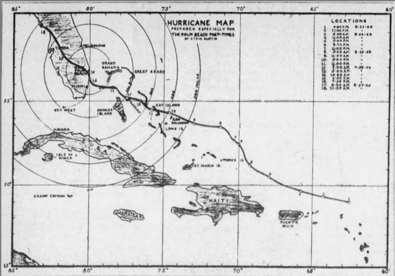
In 1949, an unnamed Category 4 hurricane made landfall between Lake Worth Beach and Lantana in Palm Beach County on Aug. 26. Palm Beach Post archived articles say 2,000 of West Palm Beach’s 7,000 homes were damaged, “more than a million dollars worth of planes” were beat up at what was then the West Palm Beach International Airport, and that the National Guard was called in to prevent looting.
One Palm Beach Post article called the hurricane an “apocalyptic horseman of destruction.”
Category 2 Hurricane Cleo made landfall near Miami Beach on Aug. 27, 1964. It bustled along the coast remaining a Category 1 through Boca Raton and continued as a tropical storm hugging the coast through Jacksonville.
“If there was a homeowner who escaped Cleo’s kiss, he was not to be found Thursday,” wrote a Miami Herald reporter the day after the storm.
What are the chances an Atlantic hurricane will form in early August?
Alex DaSilva, lead hurricane forecaster for AccuWeather, said on July 30 that it’s unlikely a hurricane will form this year before Aug. 11 — the average date for the first hurricane. But he’s not ruling out a depression or storm.
“We are forecasting four to eight hurricanes, but we are leaning more toward four or five, which is below average,” he said. “El Niño doesn’t mean the whole season will be dead.”
The climate pattern El Niño sends storm shredding wind shear through the tropical Atlantic as warming Pacific waters change thunderstorm and upper air patterns. AccuWeather is predicting more than a 90% chance of a “super El Niño” forming.
While there is no official definition of a “super El Niño”, a very strong event would be designated if Pacific sea surface temperatures are 2 degrees Celsius or 3.6 degrees Fahrenheit warmer than normal. During the 2015-2016 “Godzilla” El Niño, water temperatures peaked at 2.37 degrees Celsius (4.26 Fahrenheit) warmer than normal.
AccuWeather is hinting at an area in the southwestern Atlantic for possible development in the early part of August as cool fronts droop down to invigorate any spin that may be there. The periphery of the Bermuda High may also be nosing west, adding some vigor to the atmosphere.
Places included in the bulging area of interest are Florida, the Bahamas, Georgia and the Carolinas.
“It is just an area to watch because we think the rest of the basin is pretty much shutdown,” DaSilva said. “There is a very, very, very low chance, but it’s just something to watch.”
Andy Hazelton, a scientist at the University of Miami’s Cooperative Institute for Marine and Atmospheric Studies, called the Atlantic basin “barren” of storm activity in a social media post.
He did point to the potential in early August for an area of low pressure to form northwest of Puerto Rico. Under the right conditions, areas of low pressure turn into tropical cyclones. By July 31, a few weather models had picked up on the potential for a tropical cyclone to develop win the southwest Atlantic, which Hazelton said was worth keeping an eye on.
“I’d probably put the chances of something developing here at less than 10%, but it’s about the only feature to watch in an otherwise barren Atlantic,” he said.
Kimberly Miller is a journalist for the USA TODAY NETWORK FLORIDA. She covers weather, the environment and critters as the Embracing Florida reporter. If you have news tips, please send them to kmiller@pbpost.com. You can get all of Florida’s best content directly in your inbox each weekday by signing up for the free newsletter, Florida TODAY, at palmbeachpost.com/newsletters.
This article originally appeared on Palm Beach Post: It’s August and Florida needs to remember Andrew, Charley and Cleo
Reporting by Kimberly Miller, USA TODAY NETWORK – Florida / Palm Beach Post
USA TODAY Network via Reuters Connect
By Kimberly Miller, USA TODAY NETWORK – Florida | USA TODAY Network
