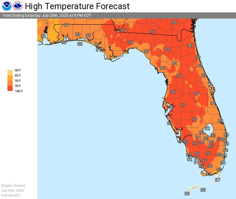
Florida remains sweltering, with the “feels like” heat index for Monday, July 28, expected to reach up to 113 degrees in Okaloosa County, per the National Weather Service.
Heat advisories are in effect for portions of Florida, including Okaloosa County

➤ Weather alerts via text: Sign up to get updates about current storms and weather events by location
According to the National Weather Service, a heat advisory means that temperatures of at least 100 degrees or heat index values of at least 105 degrees are expected generally within the next 24 hours.
Heat advisory issued in parts of Florida. Here’s where
How hot will it be on July 28 in Fort Walton Beach?
According to the National Weather Service, the high temperature will be 100 degrees and the heat index value will be up to 113. A heat advisory will be in effect between 10 a.m. and 6 p.m.
Will it be any cooler on Tuesday, July 29?
Not really. According to the National Weather Service, the high temperature is expected to be 98 degrees.
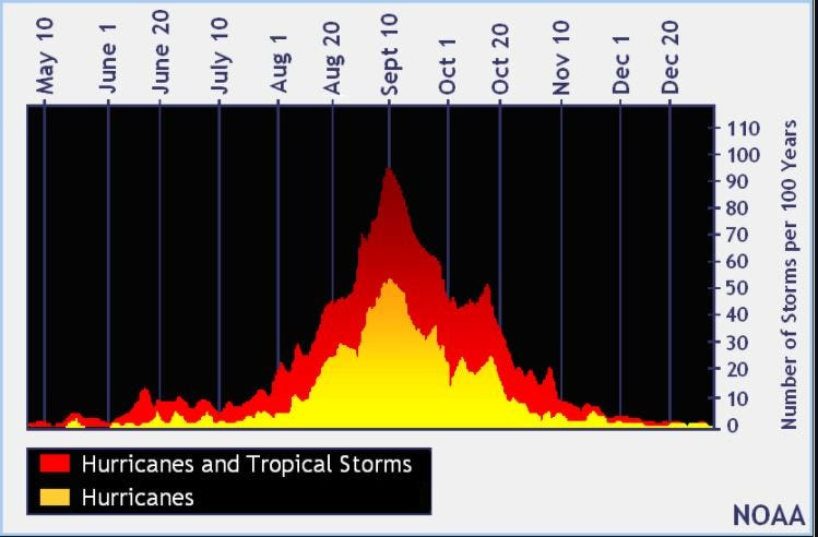
2025 hurricane season so far
An average Atlantic hurricane season has 14 named storms, seven hurricanes, and three major hurricanes.
Here’s when this year’s named storms have developed, compared to historical averages:
➤ How to set up emergency cellphone notifications for flash flood warnings and safety tips
➤ Excessive rainfall forecast
Hurricane names for 2025 season
Here are the names for the 2025 Atlantic hurricane season, along with how to pronounce them:
When is the Atlantic hurricane season?
The Atlantic hurricane season runs from June 1 through Nov. 30.
Ninety-seven percent of tropical cyclone activity occurs during this time period, NOAA said.
The Atlantic basin includes the northern Atlantic Ocean, Caribbean Sea and Gulf of America, as the Gulf of Mexico is now known in the U.S. per an order from President Trump. NOAA and the National Hurricane Center are now using Gulf of America on its maps and in its advisories.
When is the peak of hurricane season?
National Hurricane Center map: See what forecasters watching now
Systems currently being monitored by the National Hurricane Center include:
Why does NHC say ‘tropical cyclone’ on its maps instead of hurricane or tropical storm?
Tropical cyclone is the generic term used by the National Weather Service, NOAA and the National Hurricane Center for any tropical system, even if it’s in the tropical Atlantic basin.
To be more precise, a tropical cyclone is a “rotating, organized system of clouds and thunderstorms that originates over tropical or subtropical waters and has closed, low-level circulation,” NOAA said.
Once maximum sustained winds reach 74 mph, what it is called is determined by where it originated:
Interactive map: Hurricanes, tropical storms that have passed near your city
Stay informed. Get weather alerts via text
What’s next?
We will update our tropical weather coverage daily.
Download your local site’s app to ensure you’re always connected to the news. And look for our special subscription offers here.
Jim Ross contributed
This article originally appeared on Northwest Florida Daily News: Fort Walton Beach expects heat index of 113 on July 28; extreme heat pounds Florida
Reporting by Kim Luciani and Cheryl McCloud, USA TODAY NETWORK – Florida / Northwest Florida Daily News
USA TODAY Network via Reuters Connect