Man it’s a hot one, like seven inches from the mid-day sun. Fortunately, just like the ocean under the moon, the first month of hurricane season has been so smooth that you could easily forget about it: only this week did 2025 clock its first Atlantic storm while eastern U.S. temperatures soared as high as 105°F.
You may celebrate with Carlos Santana’s signature sparkling wine.

Unlike the bold, undeniable flavors of Santana DVX, Tropical Storm Andrea was weak, short-lived, and has long since dissipated well northeast of Bermuda. Thus, the Atlantic, Gulf, and Caribbean are again quiet, and tropical storm formation is not expected through at least late next week.
However, a change in the weather is ahead for Florida and the Southeast; the strong ridging that brought that ludicrous eastern heat is weakening as it is undercut by an upper-level low moving west into the Deep South today.
That upper low will meander over the Southeast for the next 7 days, bringing temps from oven self-cleaning down to low broil as rain chances rise from Southwest Florida north to the Panhandle and west to the central Gulf Coast.
After a front sags towards the Southeast late next week, we’ll have to keep an eye on the northeastern Gulf or south of the Carolinas for the slight possibility of tropical development in 8-10 days (or beyond). I’m not concerned about any potential threat, but hurricane history does tell us to keep an general eye on stalled fronts near the Gulf Stream at this time of year.
The only other minuscule potential for an Atlantic storm this week is in the extreme southern Gulf over the weekend. A named storm is far more likely to form in the Eastern Pacific than the Gulf, but should not impact the U.S. coast in any case.
As July opens, don’t think we are off the hurricane hook
July is a transitional month of hurricane season. By the end of it, the primary seeds for developing storms are tropical waves, a change from a mix of Central American Gyres, stalled fronts, non-tropical lows, and tropical waves at the beginning of July.
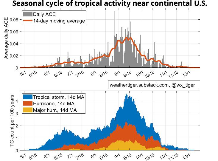
Despite those diverse sources of storms, only about 7% of the Atlantic hurricane season in energetic terms happens before Aug. 1, so don’t draw conclusions about the season as a whole from its languid first couple of months.
Why is Atlantic hurricane season so tightly packed into its August-to-October peak? Well, just as a supernatural groove requires the teamwork of Carlos Santana and Rob Thomas, tropical cyclone formation, also known as cyclogenesis, requires the interplay of six necessary oceanic and atmospheric ingredients.
Switching gears from Santana to Genesis, let’s see what it takes for an innocuous cloud clump to score highly on the Phil Collins Index and possibly become a raging hurricane.
Invisible Touch: The role of the ocean in Hurricane genesis
First, a little about a tropical cyclone’s essential structure.
Tropical cyclones develop in relatively uniform air masses; like garden-variety thunderstorms, their fundamental source of energy is the differential between the warm surface (in this case, the ocean) and the cold upper atmosphere, not east-to-west gradients in temperatures as with frontal lows.
Most of the time, those thunderstorms collapse on themselves in a matter of hours, but under the right conditions, they can touch off a self-sustaining vicious cycle.
Here’s how it works: the rising air in a disorganized thunderstorm cluster lowers atmospheric pressure at the surface. Nature abhors a vacuum, so surrounding air rushes toward that lower pressure and begins rotating due to the Coriolis force, taking heat and moisture from the warm ocean as it does.
Winds converge under the existing convection, causing a traffic jam of warm, moist air with nowhere to go but up. The water vapor in that rising air condenses into clouds as it ascends, releasing more heat, triggering more convection and more inflow, and potentially kicking off an upward-spiraling feedback cycle that leads to hurricane formation.
In order for this feedback to take place, tropical cyclones usually need a thick layer of water warmer than 80°F, as the entire process removes heat from the ocean and upwells cooler water from depth.
Additionally, the cycle requires sufficient humidity in the mid-levels of the atmosphere and a cold enough upper atmosphere such that the ascending air remains buoyant and can rise high, forming intense, deep convection.
In the Air Tonight: Atmospheric prerequisites for tropical cyclones
However, unlocking the potential energy of the oceans requires a co-operative atmosphere.
First and foremost, the cyclogenesis process is very sensitive to vertical wind shear, or changes in wind speed and direction with altitude. If winds aloft are too different from winds near the surface, convection is ripped apart rather than being vertically “stacked” and intense, which reduces the efficiency of the cycle to the point it isn’t self-sustaining.
Additionally, the cyclogenesis process needs help to get started in the form of an initial disturbance to seed it with low-level rotation. The most common progenitors for Atlantic tropical storms are African easterly waves, which as the name suggests are wave-like windfield patterns that move west across the Tropical Atlantic in summer and fall.
Tropical cyclone development also requires some Coriolis force, so genesis almost always occurs more than 5° away from the Equator.
That’s All: Putting the pieces together
So, when and where do tropical cyclones form in the Atlantic, Gulf and Caribbean?
Times and places in which low shear, elevated moisture and warm oceans overlap is surprisingly uncommon. Early in hurricane season, the waters of the Eastern Atlantic are too cool to support strong storms, and Saharan dust outbreaks impinge on mid-level moisture in July and August just as wind shear is most favorable.
Moisture and sea surface temperatures are conducive in October and November, but wind shear increases dramatically in the fall as mid-latitude weather plows further south.
In fact, the only time of year that shear, mid-level moisture, and instability are all usually favorable for hurricane development is September, when ocean waters are at their warmest in the Atlantic Basin.
That’s why 75% of the total storm energy of hurricane season and 80% of U.S. major hurricane landfalls occur between August 15th and October 15th, a much narrower window than the official June to November span of hurricane season. Basically, tropical cyclone genesis comes down to shear times moisture times instability, otherwise known as the Phil Collins Index (PCI).
Storms can’t dance without it, and as will be true for the upcoming week, low PCI means you’re unlikely to see much as you keep watching the skies.
Dr. Ryan Truchelut is chief meteorologist at WeatherTiger, a Tallahassee company providing forensic meteorology expert witness services and agricultural and hurricane forecasting subscriptions. Visit weathertiger.com to discover how to put our expertise to work for you and access our real-time 2025 seasonal hurricane forecast model data.
This article originally appeared on Tallahassee Democrat: Florida Tropics forecast: Slow June doesn’t mean we are off the hurricane hook
Reporting by Ryan Truchelut / Tallahassee Democrat
USA TODAY Network via Reuters Connect