The news hasn’t improved when it comes to Florida and wildfires.
While the number of active wildfires documented by the Florida Forest Service dropped slightly overnight — from 137 to 134 — until the arrival of Florida’s rainy season, there’s just no overcoming months of drought.

➤ Weather alerts via text: Sign up to get updates about current storms and weather events by location
The 134 active fires at 7 a.m. April 24 were burning almost 26,000 acres.
As of 6 a.m. April 24, one road in the state — in Levy County — was closed due to a wildfire. Smoke from other wildfires can affect visibility in several other counties. The Florida Highway Patrol is urging motorists to use caution.
The air quality in most of Florida ranges from good to moderate, although for residents in the Jacksonville area, the air quality is “unhealthy for sensitive groups.”
Here’s the latest on conditions April 24.
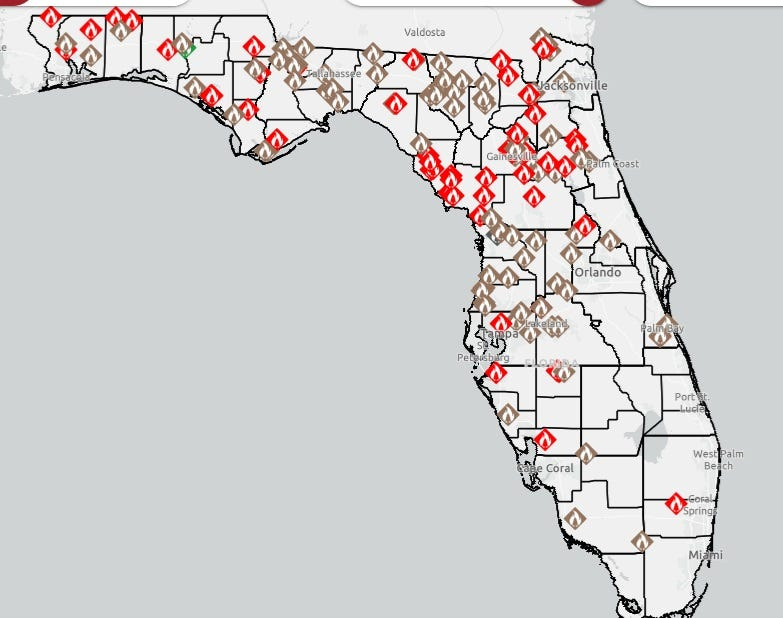
Map shows location of active wildfires, smoke impacts across Florida
As of 6 a.m. April 24, there were 134 active wildfires burning 25,786 acres across Florida.
According to the Florida Department of Agriculture and Consumer Services, between Jan. 1 and April 19 in Florida:
FEMA authorizes federal funds to reimburse costs to fight 2 Florida fires
FEMA authorized federal funds to reimburse costs to Florida to fight the Railroad Fire burning in Putnam and Clay counties, the agency announced in a news release April 22.
On April 23, the agency also authorized the use of federal funds to reimburse Florida the cost to fight the Cow Creek Fire in Levy County.
“On April 22, the state of Florida submitted a request for a Fire Management Assistance Grant for the Railroad Fire Complex.
“At the time of the request, the (Railroad) Fire threatened more than 1,500 homes, three businesses and community infrastructure in and around Putnam and Clay counties. Two shelters are open … and approximately 220 people have voluntarily evacuated,” FEMA said.
As of April 23, the Cow Creek Fire in Levy County has burned more than 1,600 acres, and threatens more than 1,200 homes near the Gulf Hammock Community, Moriston and Williston areas, FEMA said April 23.
The Fire Management Assistance Grants provide federal funding for up to 75% of eligible firefighting costs.
Are any Florida roads closed due to smoke?
According to the Florida Highway Patrol, at 6 a.m. April 24 one road was closed, although smoke could affect visibility in several other areas. Here’s what the FHP has noted on its website:
Smoke affecting air quality in some Florida counties
According to the EPA, the worst air quality in the state is in the area of Jacksonville in Northeast Florida, where the air quality is “unhealthy for sensitive groups.”
Elsewhere, despite the number of wildfires and associated smoke, the air quality is mostly good.
➤ See breakdown of air quality by Florida county
Current drought conditions in Florida
The U.S. Drought Monitor on April 21 (the latest date with data available) provided the following breakdown on how bad the drought is in Florida:
➤ Strict water use rules sweep the nation ahead of summer
Drought and dryness categories: 99% of Florida
Total area in drought: 99%, impacting 18.1 million Florida residents.
The drought monitor said January-March 2026 is the ninth driest period on record, which date back to 1895.
Burn bans increase to 42 Florida counties
As of 6 a.m. April 24, burn bans have been issued for 42 of Florida’s 67 counties.
What is a burn ban?
The Florida Forest Service tries combines all county-enacted burn bans on its website.
A burn ban typically prohibits the outside burning of yard trash and vegetation, as well as campfires, bonfires and burn barrels, but can vary by county.
➤ Current Florida fire danger map
Burn bans are issued when there’s a high risk for wildfires and include such conditions as:
What is the Keetch-Byram Drought Index?
The Florida Forest Service and U.S. Forest Service use the Keetch-Byram Drought Index to measure the risk of wildfires based on soil moisture, how dry fuel is, and precipitation.
The scale ranges from 0 to 800, with 0 indicating saturated soil and 800 representing extreme drought with a high potential for “intense, deep-burning fires.”
Interactive map: Enter your address to find closest wildfire risks
Stay informed. Get weather alerts via text
What’s next?
We will continue to update our weather coverage as conditions warrant. Download your local site’s app to ensure you’re always connected to the news. And look for our special subscription offers here.
Cheryl McCloud is a journalist for the USA TODAY Network-Florida’s service journalism Connect team. You can get all of Florida’s best content directly in your inbox each weekday day by signing up for the free newsletter, Florida TODAY, at https://tallahassee.com/newsletters.
This article originally appeared on Tallahassee Democrat: Florida is burning. See location of current wildfires, road closures
Reporting by Cheryl McCloud, USA TODAY NETWORK – Florida / Tallahassee Democrat
USA TODAY Network via Reuters Connect