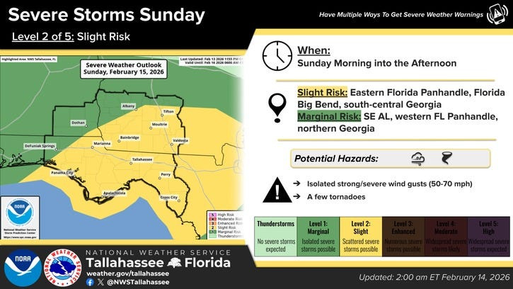
The National Weather Service has notched up the chances the Tallahassee area could see severe weather on Sunday, warning that strong thunderstorms could bring damaging winds, heavy rainfall and the possibility of a brief tornado as a cold front and squall line moves through North Florida.
Forecasters say the thunderstorms are expected to reach the region late Sunday morning or early afternoon. The Storm Prediction Center has placed much of the eastern Florida Panhandle and the Florida Big Bend, including Leon County, under a Slight Risk for severe weather, a Level 2 out of 5.

According to forecasters, damaging wind gusts will be the primary threat, but “a tornado or two cannot be ruled out,” particularly with storms embedded within the main squall line.
Along with the severe weather threat, the system is expected to deliver beneficial rainfall. Forecasters estimate a 60 to 80 percent chance that Tallahassee and nearby communities will receive more than an inch of rain from Saturday night through Sunday night. There is also about a 30 percent chance that some locations could see rainfall totals topping two inches.
While the rain will help ease dry conditions, meteorologists caution that the storms could be disruptive during the day Sunday.
“It’s also worth noting that just to keep pace with normal rainfall this time of year, we need about 1″ to 1.25″ of rain every week,” forecasters wrote in the morning discussion. “So while this rain will be beneficial, it’s not likely to put a dent in the ongoing drought conditions across the region.”
Storm timing for Tallahassee
The strongest storms are expected to move into Tallahassee and the Florida Big Bend between roughly 11 a.m. and 6 p.m. Eastern Time on Sunday. This window includes the potential for the most intense weather, including strong wind gusts capable of downing tree limbs or causing scattered power outages.
Forecasters also say there is a chance for additional strong storms to develop Sunday afternoon and early evening after the main line passes, before activity weakens around sunset.
Ahead of the storms, Tallahassee could experience breezy conditions even outside of thunderstorms. Southerly winds may gust between 30 and 35 mph, with higher gusts possible in heavier showers or storms.
Tornado risk remains low but possible
Meteorologists describe Sunday’s setup as one that favors strong winds, but not widespread tornado activity. Still, the combination of strong wind shear and limited instability means an isolated tornado cannot be ruled out, especially if storms intensify more than expected.
Forecasters will be closely monitoring whether morning fog clears earlier than anticipated. If sunshine allows temperatures to climb into the upper 70s, the risk for more intense storms — including a higher tornado threat — would increase. At this time, that scenario remains unlikely.
Calmer, warmer weather ahead
Once the storms move out Sunday night, quieter weather is expected to return to Tallahassee on Monday and last through much of next week. High temperatures are forecast to reach the mid to upper 70s, with some days approaching 80 degrees by midweek.
This article originally appeared on Tallahassee Democrat: Chances edge up for Tallahassee severe weather: What to expect
Reporting by Staff reports, Tallahassee Democrat / Tallahassee Democrat
USA TODAY Network via Reuters Connect