Close your eyes and picture what a hurricane looks like on the ground.
What do you see? Is it a shredded palm tree impaled by a 2×4? Perhaps a hapless pier carried out to sea by a froth of surge and waves? Maybe Jim Cantore having a kinetic encounter with a traffic control device?

Whatever you’re visualizing, it probably isn’t inland flooding, but based on the last week’s, year’s, and decade’s worth of tropical cyclone impacts, it should be.
➤ Track all active storms
➤ Weather alerts via text: Sign up to get updates about current storms and weather events by location
The too-little discussed killer tropical threat: Freshwater flooding deaths
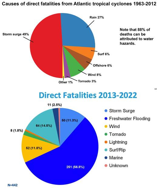
Freshwater flooding — along with surge, wind, and tornadoes, one of the primary hurricane threats and impacts — is perhaps the most underestimated, least understood, and most difficult to manage of those four horsemen.
In fact, as wind and surge forecasts and mitigation strategies have dramatically improved, the proportion of tropical cyclone deaths due to extreme rainfall has risen from around 25% in the late 20th and early 21st Century to over 50% in the last dozen years.
Freshwater flooding accounts for about 15% to 20% of total damages from tropical cyclones, with the worst impacts often occurring hundreds of miles inland, days after the frisson of landfall has faded.
Long-lasting river flooding, like that following Ian in Central Florida, can linger for months and forestall the recovery process. As standard property insurance does not cover flood losses, excessive precipitation accounts for a disproportionate share of both the lives and livelihoods lost to tropical cyclones.
Little immediate Florida threat brewing in the tropics
As we find ourselves in a typical mid-July lull in hurricane season, this is a good moment to consider the life-threatening flood hazard even “weak” tropical systems can pose. Currently, the Atlantic, Caribbean, and Gulf are being scoured by elevated wind shear in the west and dusty, sinking airmasses in the east.
That means there are no tropical disturbances with a meaningful shot at development over the upcoming seven days. Way down the road, it’s worth keeping half an eye on the northern Gulf or east of Florida late next week, where a front may once again stall and act as a focus for convection.
Right now, that just looks like enhanced rain chances, but like Chantal, sometimes tropical organization slowly results.
How Texas became a gut-wrenching and cautionary tale for those who live even outside of hurricane country
Recent history shows there is no correlation between the perceived intensity of a storm, and the rainfall impacts it produces. Unless you are an extreme weather aficionado, you probably had no awareness of Tropical Storm Barry during its brief existence.
I don’t blame you. Barry was barely a tropical storm over the far southern Gulf for 24 hours, and weakened to a depression as it moved inland on June 29. Even some meteorologists thought this one was a bit iffy in terms of whether Barry qualified as a tropical cyclone at all.
Unfortunately, that wasn’t the end of the story.
While Barry’s surface circulation quickly dissipated over Mexico, its harder-to-kill mid-level turning bumbled north for several days in a weak steering current environment, dragging a payload of deep Gulf moisture with it into central Texas.
By the holiday weekend, additional moisture streamed into Texas from the southwest, originally associated with outer bands of the Eastern Pacific’s Hurricane Flossie.
Together, these sources of spin and moisture set the stage for the development of a mesoscale convective system (MCS), basically a scaled-up thunderstorm complex that can sustain itself longer than garden-variety convection by pulling in warm, moist air from a wide area.
The MCS that formed over the Texas Hill Country on the night of July 3 and 4 moved little due to light winds aloft, keeping the heaviest precipitation of 10 to 20 inches locked in place over the highly flood-prone Guadalupe River basin, in the middle of the night, with surface run-off exacerbated by extreme to exceptional drought.
Despite timely flood warnings from the National Weather Service, tragically, the meteorological elements combined with limited emergency infrastructure and planning for an absolute worst-case outcome.
From Barry and Texas to Chantal: Back-to-back once-in-a-century rain events
Nor was Barry the only example in the past week of extreme precipitation from an unassuming source.
Tropical Storm Chantal came ashore near Myrtle Beach on July 6, with modest sustained winds of 50 mph. For most in the Carolinas, Chantal was a wind, surge, tornado, and even rainfall non-event.
However, as Chantal moved inland, an interaction between the storm and a mid-latitude weather feature caused a localized 5 to 10-plus inches of rain to fall over several counties in central North Carolina.
Flooding in these areas, particularly along the Haw River, pushed or exceeded all-time records.
As in Texas, Chantal’s 12- to 24-hour rain totals are estimated as a once-a-century event, though climate change is likely nudging such formerly exceptional rain rates toward being somewhat less rare.
A history of deadly rainmakers: From Alberto and Alison to Helene
Weather history is littered with other cases in which the wind-based classification of tropical cyclones belied their severe flooding impacts.
About half of the deadliest floods in the U.S. over the last 60 years have been triggered by Atlantic tropical activity; of those, half stemmed from systems whose sustained winds peaked at or below Category 1 intensity.
That includes Tropical Storms Alberto (1994) and Alison (2001), which produced Houston-area flooding exceeded only by Harvey. In fact, no name is necessary. Devastating 2016 floods in Louisiana were caused by a tropical disturbance never even classified as a depression.
The other half of tropical-cyclone-related floods were caused by hurricanes that peaked as Category 4 or 5, though each produced its heaviest precipitation and worst flooding hundreds of miles from landfall, often in a small area.
Camille ravaged Mississippi, but produced floods that killed over 150 people in a single county in Virginia. Ida struck eastern Louisiana, but stunned New York and New Jersey with flash floods days later.
More recently, the absolute worst of Helene’s wrath was reserved for western North Carolina, where mountains wrung feet of rain out of copious Gulf moisture.
After an epic meteorological tragedy, where do we go from here?
And therein lies the forecast — and forecast communication — problem.
Meteorologists are relatively good at identifying general areas that are at high risk of excessive rainfall days ahead of time, but even following a tropical cyclone, typically only a small portion of that region will actually see truly dangerous flooding.
Pinpointing that zone is something that often can’t be done until just hours ahead of time, sometimes not until the extreme precipitation is already underway.
The hurricane hazard mantra of hide from wind, run from water has been internalized when it comes to coastal storm surge, but proactive evacuations are much less common for inland freshwater flooding due to the forecast challenge and the propensity for floods to strike areas where people are less attuned to hurricane threats.
We need to continue to improve the skill of hyper-localized flood forecasts and the reach of actionable warnings, because this is the main way people are dying from tropical cyclones in the 21st Century. Sounds like a good reason not to zero out the budget for the NOAA labs where this research is being done, wouldn’t you agree?
In closing, there are no natural disasters. There are choices about exposures and vulnerabilities to natural hazards.
We’ve come a long way in predicting and mitigating hurricane wind and surge risks, yet as the tragic start to July 2025 shows, less far in managing and understanding freshwater flooding hazards that are equally dire.
Tropical cyclone flooding will never be tamed, but as a society, this is an area where we clearly can make better choices in perceiving and managing the threat to make future tragedies less likely.
Keep watching the skies.
Dr. Ryan Truchelut is chief meteorologist at WeatherTiger, a Tallahassee company providing forensic meteorology expert witness services and agricultural and hurricane forecasting subscriptions. Visit weathertiger.com to learn more. Email Truchelut at ryan@weathertiger.com.
This article originally appeared on Tallahassee Democrat: Beyond the eye: How rain, not wind or surge, became the deadliest tropical hazard
Reporting by Ryan Truchelut / Tallahassee Democrat
USA TODAY Network via Reuters Connect