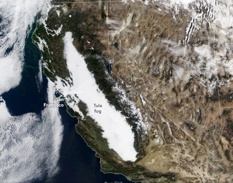
The Sacramento and San Joaquin valleys — nearly 400 miles from Bakersfield to Redding — have woken up most mornings since before Thanksgiving under a stubborn blanket of mist and fog.
The murky weather has floated over orchards, highways and entire cities, reducing visibility for millions of Californians and challenging drivers on Interstates 5 and 80 and dozens of connecting state routes, including the always busy Highway 99.

According to the National Weather Service, the worst visibility this week settled over the northern Sacramento Valley, from Redding to Red Bluff, with pockets of dense fog also forming along Interstate 80 east of Sacramento. Conditions weren’t much better to the south: mist and occasional fog stretched into Kern County, adding a winter complication to one of the nation’s busiest freight corridors.
While fog is nothing new in the Central Valley, residents say the duration of this year’s gloom is becoming the story.
“Never lasted this long in my 57 years here,” said Greg Clark of Redding told USA TODAY Network’s Redding Record Spotlight.
Statewide, Californians are asking the same questions: What’s causing this persistent fog and mist? How dangerous are conditions on the road? And when will the Valley see the sun again?
Here’s what to know about the science, safety tips and seasonal forecast behind Tule fog:
Where Tule Fog is worst across California right now
As of Jan. 24, dense tule fog continues to blanket large portions of California, with the most dangerous conditions concentrated in the Sacramento Valley and San Joaquin Valley, though pockets of low visibility have extended north and south along major transportation corridors.
The worst and most persistent fog has been reported in:
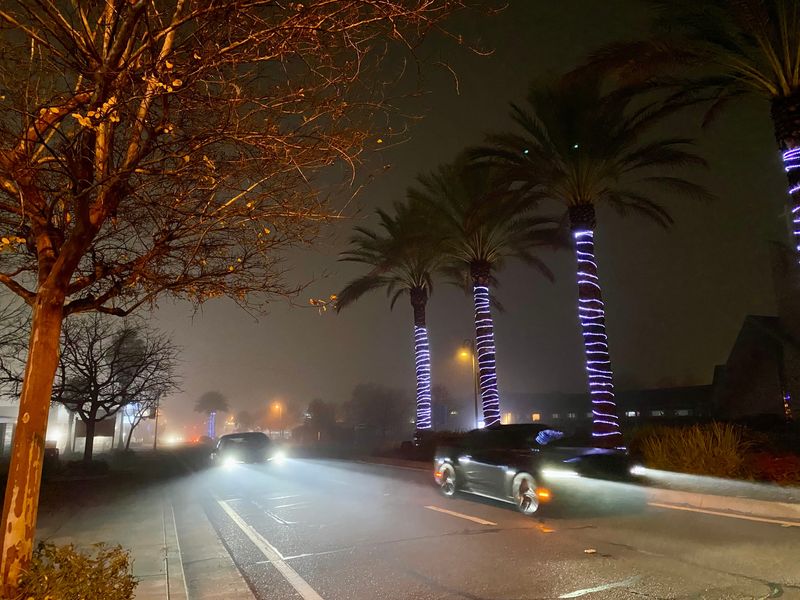
The California Highway Patrol says it has responded to dozens of fog‑related crashes statewide over the past two weeks, with at least two confirmed fatalities in Fresno County alone. Investigators say dense fog was a primary factor, compounded by unsafe speeds and by drivers exiting vehicles in near‑zero visibility.
Weather officials warn that conditions can deteriorate within seconds, and that tule fog is expected to redevelop overnight and during early mornings until a strong weather system fully disrupts the stagnant air mass trapping moisture near the ground.
How Tule fog is formed
California’s Central Valley has always been a natural fog factory. But this year’s prolonged murk comes from an unusual mix of atmospheric ingredients.
A high‑pressure system parked over the state has been pressing low‑lying clouds toward the ground, trapping moisture at the surface, said Eric Kurth of the National Weather Service’s Sacramento office.
“The Central Valley is basically a big bowl of mist,” Kurth told the Redding Record Searchlight.
Much of what Californians have been experiencing is mist rather than fog. The difference is visibility:
Low‑altitude valleys from Bakersfield to southern Tehama County have been “filled with mist,” Kurth said. True tule fog — the region’s famous thick ground-level cloud — has been forming mainly north of the Tehama County line, lingering from dusk to late morning on many days.
What makes Tule Fog special?
Tule fog is a type of radiation fog, typically forming in the Central Valley from November through February when the following conditions line up:
NASA explains the phenomenon and its name — derived from tules, a native bulrush plant central to the culture and economy of tribes such as the Wintun and Yokuts — in its overview of Central Valley fog formation.
Meteorologist Jan Null, a former NWS forecaster and current San Jose State professor, told the Sacramento Bee this: “The perfect recipe for radiation fog is low-level moisture, clear skies and light winds.”
NASA notes that tule fog has declined in frequency in recent decades, potentially due to long-term warming trends.
But this year? It’s back in force — especially in the northern Valley, where daily burn-off hasn’t kept up with new overnight formation.
Driving tips in Tule Fog
The National Weather Service and NOAA strongly urge drivers to avoid travel during periods of dense fog — but for millions of commuters and truckers in the Central Valley, that’s not always possible.
If you must drive in fog:
Slow down — and leave early.
Expect doubled or tripled travel times during morning hours.
Use low-beam headlights.
High beams reflect off fog, making visibility worse. Fog lights can help, if your vehicle has them.
Increase following distance.
Give yourself extra time to react to sudden stops.
Watch the lane lines.
When visibility shrinks below a quarter-mile, the painted lines become your best guide.
If visibility becomes unsafe:
NOAA driving tips: https://www.weather.gov/safety/fog
For live highway conditions, the California Highway Patrol and Caltrans maintain an interactive map:https://quickmap.dot.ca.gov
When will the tule fog lift in the Central Valley?
For now, don’t expect much relief from the Central Valley fog.
Forecasters say Central Valley residents are likely stuck with dense tule fog for several more days — and possibly longer — as a stubborn atmospheric setup keeps moisture trapped near the ground. With no significant rain in the long‑range forecast and no strong winter storm to scour out the valley atmosphere, the foggy pattern is expected to persist, according to the National Weather Service.
“This is a classic inversion pattern,” forecasters at the National Weather Service office in Hanford said in their latest area forecast discussion, noting that light winds and stable high pressure are allowing fog to redevelop night after night across the San Joaquin Valley.
This article originally appeared on Palm Springs Desert Sun: Tule fog grips California’s Central Valley with no relief in sight
Reporting by James Ward and Jessica Skropanic, Palm Springs Desert Sun / Palm Springs Desert Sun
USA TODAY Network via Reuters Connect