
A short-lived tropical storm could develop later today or June 17 in the Gulf.
If the system strengthens, it would become Tropical Storm Arthur, the first named storm of the 2026 Atlantic hurricane season.

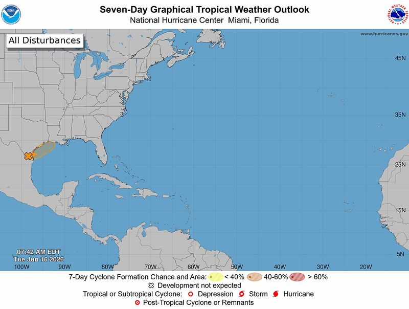
The National Hurricane Center began issuing advisories on the system, now designated as Potential Tropical Cyclone One, at 11 a.m. June 16.
➤Track Potential Tropical Cyclone One
Are you prepared for hurricane season? Now is the time, before a storm appears. Here is a list of supplies you should have for the season.
Shop Amazon for all your hurricane needs
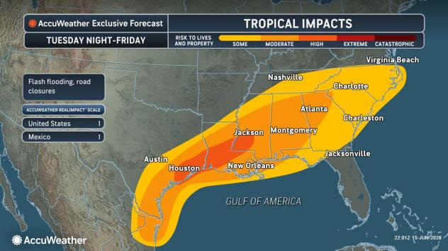
AccuWeather forecasters are predicting the system will bring very heavy rain — up to 12 inches in some areas and up to 20 inches in some localized areas — from eastern Mexico through southern and eastern Texas to the western Carolinas and Georgia.
Some rain could be felt across Florida’s Panhandle, but the state should miss most of the heavy rain associated with the system, according to Alex DaSilva, AccuWeather lead hurricane expert, via email June 15.
In the Atlantic basin, there have been no named storms as of June 16. Wind shear and Saharan dust have been helping prevent tropical development, although there are four tropical waves out there.
➤ Weather alerts via text: Sign up to get updates about current storms and weather events by location
Florida residents shouldn’t be concerned about the tropical waves.
“The first waves that come off Africa are usually too far south, and there’s often too much dry air and wind shear for them to develop,” DaSilva said.
Countdown to end of 2026 Atlantic hurricane season
Could Florida be impacted by tropical storm this week?
“Concern continues to grow over this potential tropical area in the western Gulf,” DaSilva said.
The system is “packing an abundance of moisture,” and has the potential to evolve into a tropical depression or even a tropical storm.
➤ How creeping chance of tropical system would impact Pensacola
The main threat will be torrential downpours, although Florida has a low risk of seeing any rain or wind impacts as of June 16.
The National Weather Service Mobile warned “multiple rounds of showers and storms are expected.” Rainfall totals of 3 to 6 inches, with locally higher totals up to 8 inches are possible through June 19.
“Moisture from the remnants of a potential tropical systems may enhance the flood potential for a portion of the area” June 18-19.”
Adding to the threat is a cold front moving in from the north is expected to merge with the disturbance.
➤ June hurricane season forecast from WeatherTiger: A time for wet and weak storms
“Overall, Florida is expected to miss most of the heavy rain. The heaviest rain in Florida will likely occur in the western Florida Panhandle during the middle to late portions of the week.
The most common locations for June storms to develop are the northwestern Caribbean, eastern Gulf, and off the Southeastern U.S. coast, said Dr. Ryan Truchelut, chief meteorologist at WeatherTiger, who works with the USA TODAY Network.
National Hurricane Center tracking Potential Tropical Cyclone One
Latest conditions in the Atlantic basin 8 a.m. June 16:
Potential Tropical Cyclone One: A broad area of low pressure located inland over south Texas is producing a large area of disorganized showers and thunderstorms.
The system is forecast to move northeastward along the Texas coast and could emerge over the northwestern Gulf of America later today or tonight.
Environmental conditions are expected to be marginally conducive for the formation of a short-lived tropicalstorm late June 16 or on June 17, especially if the system moves far enough offshore.
➤ Track Invest 90L
Regardless of tropical cyclone formation, interests across southern and eastern Texas and portions of Louisiana and Mississippi should prepare for periods of intense rainfall over the next several days which could produce widespread, life-threatening flash, urban, and river flooding.
Gusty winds and coastal flooding are also possible along portions of the northwestern Gulf Coast, and tropical storm watches or warnings could be required later in the day June 16.
➤ Hurricane Center testing new cone: What’s changing this season?
Spaghetti models for Potential Tropical Cyclone One
Special note about spaghetti models: Illustrations include an array of forecast tools and models, and not all are created equal. The Hurricane Center uses only the top four or five highest performing models to help make its forecasts.
What is a potential tropical cyclone?
A potential tropical cyclone is used to describe a “disturbance that isn’t a tropical cyclone but which which poses the threat of bringing tropical storm or hurricane conditions to land areas within 48 hours,” according to the National Weather Service.
National Hurricane Center tracking 4 tropical waves
National Hurricane Center forecasters are also tracking four tropical waves in the Atlantic basin:
How accurate is the prediction for development of Invest 90L in Gulf?
The National Hurricane Center’s “outlooks tend to be accurate,” Truchelut said.
“Last year, a disturbance with a 10% seven-day forecast chance of development became a tropical depression or storm about 15% of the time.”
What is a disturbance?
The National Hurricane Center’s tropical outlook map highlights “disturbances” in the Atlantic basin.
These are clusters of storms with some organization, but which don’t have a defined circulation typical of tropical cyclones.
➤ Ready or not, National Hurricane Center resumes daily tropical outlooks
If shown on the tropical outlook map in orange or red, forecasters are predicting the potential of those disturbances into developing as medium or high, respectively.
Disturbances shown on the map with a gray x have little to no chance for development. This is a change from prior years which indicated such disturbances in yellow.
What is a tropical wave?
“Tropical waves are clusters of showers and thunderstorms that act as the seedlings for many tropical storms throughout the Atlantic season,” DaSilva said.
➤ Explanation of hurricane terms we hope not to hear in Florida this year
“There are about 60 tropical waves that move across the Atlantic each year, and roughly 10 percent to 15 percent of them develop into a tropical system. That’s about one in seven.
“Tropical waves are important because they contribute to about 80 percent of all major hurricanes.”
When is hurricane season?
The Atlantic hurricane season runs from June 1 through Nov. 30.
Ninety-seven percent of tropical cyclone activity occurs during this time period, NOAA said.
➤ 2026 Atlantic hurricane season begins today. What can Florida expect?
The Atlantic basin includes the northern Atlantic Ocean, Caribbean Sea and Gulf of America, as the Gulf of Mexico is now known in the U.S. per an order from President Trump.
What are predictions for 2026 hurricane season?
Here are some of the predictions released for this year’s hurricane season.
➤ El Niño odds rise again, which could mean fewer hurricanes for Florida
A major hurricane is a storm that is a Category 3 or stronger, with maximum sustained winds of at least 111 mph.
How many tropical storms, hurricanes are in a typical season?
The 30-year average, from 1991 to 2020, is for 14 named storms, seven hurricanes and three major hurricanes.
Could Florida be hit by a hurricane in 2026? See which counties have highest chance
What are names for 2026 Atlantic hurricane season?
Names for the 2026 Atlantic hurricane season, and how to pronounce them, are:
Florida weather radar for June 16, 2026
Weather watches and warnings issued in Florida
When is the peak of Atlantic hurricane season?
The peak of the Atlantic hurricane season is Sept. 10, with the most activity happening between mid-August and mid-October, according to the Hurricane Center.
Interactive map: See how many hurricanes, tropical storms have passed near your home
Stay informed. Get weather alerts via text
What’s next?
We will update our tropical weather coverage daily to bring you the most current information you need to protect your home and family.
This story has been updated to include new information.
Cheryl McCloud is a journalist for the USA TODAY Network-Florida’s service journalism Connect team. You can get all of Florida’s best content directly in your inbox each weekday day by signing up for the free newsletter, Florida TODAY, at https://tallahassee.com/newsletters.
This article originally appeared on Tallahassee Democrat: Will we see Tropical Storm Arthur form today? Florida impacts
Reporting by Cheryl McCloud, USA TODAY NETWORK – Florida / Tallahassee Democrat
USA TODAY Network via Reuters Connect
By Cheryl McCloud, USA TODAY NETWORK – Florida | USA TODAY Network