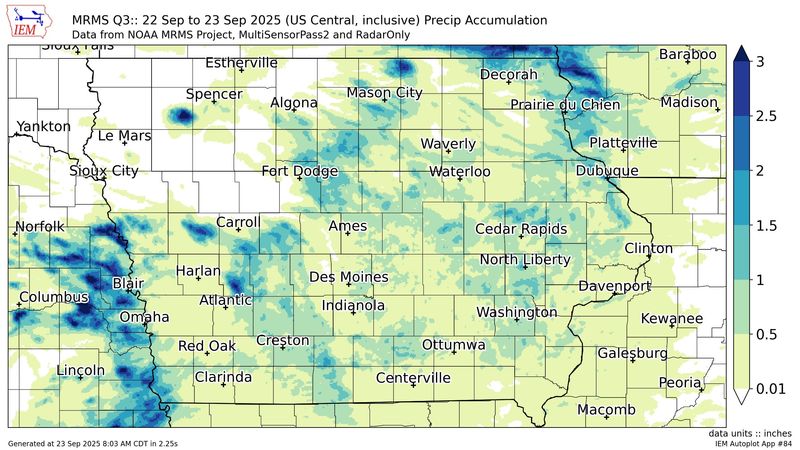
Severe thunderstorm warnings were issued for parts of central and western Iowa on Monday, Sept. 22, bringing 60 mph wind gusts, hail as large as 2 inches and rainfall.
Despite roughly an inch or less of rain falling over Iowa on Monday, parts of western Iowa have seen as much as 3 inches fall in the last week, according to the Iowa Environmental Mesonet.

How much rain did Des Moines get?
Des Moines saw 0.22 inches of rainfall from 8 a.m. Sept. 22 to 8 a.m. Sept. 23, according to the Iowa Environmental Mesonet.
Just north of Des Moines, Ankeny nearly saw more than double the rainfall, amounting to 0.47 inches of rain.
Where were the highest Iowa rainfall totals?
Here are the cities in Iowa that saw the most rainfall from 8 a.m. Sept. 22 to 8 a.m. Sept. 23, according to the Iowa Environmental Mesonet.
What is the forecast for the rest of the week in Des Moines?
The chance for rain continues into Tuesday, Sept. 23, with possible showers and thunderstorms after 1 p.m. There is a 30% chance of showers in the evening, mainly before 8 p.m., with a low of 59 degrees.
Mostly sunny skies are predicted from Wednesday, Sept. 24, and for most of the week, according to the National Weather Service for Des Moines.
What does the Iowa Doppler radar show?
Track any additional rainfall in Iowa with the latest radar loop from the National Weather Service:
Kate Kealey is a general assignment reporter for the Des Moines Register. Reach her at kkealey@registermedia.com or follow her on Twitter at @Kkealey17.
This article originally appeared on Des Moines Register: How much rain did we get? See Iowa’s highest rainfall totals from Monday
Reporting by Kate Kealey, Des Moines Register / Des Moines Register
USA TODAY Network via Reuters Connect