Update: 4:53 p.m.:
The National Weather Service office in Mobile has issued a severe thunderstorm warning for central Santa Rosa County until 5:30 p.m.

A severe thunderstorm was spotted over Bagdad, moving west at 10 mph. Wind gusts up to 60 mph, and quarter-size hail was detected.
Impacted locations include Pace, Milton, Bagdad, Pea Ridge, Roeville, Floridatown and Point Baker.
The NWS says that hail damage to vehicles is expected, along with wind damage to roofs, siding and trees.
Update 3:33 p.m.:
Escambia and Santa Rosa counties are currently under a severe thunderstorm warning until 4:15 p.m. on Wednesday.
The National Weather Service issued the warning after doppler radar picked up a strong thunderstorm over Ensley, moving west at 10 mph.
The radar picked up wind gusts up to 40 mph and half-inch size hail.
Original story:
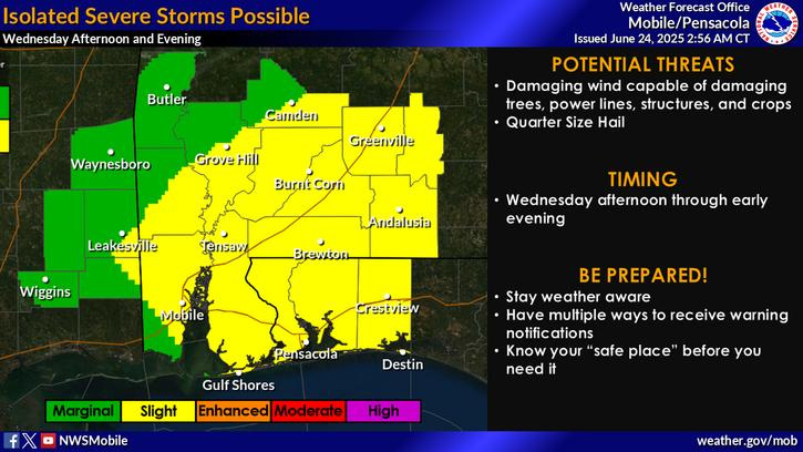
The Pensacola area has a “slight” risk of seeing isolated severe storms between Wednesday afternoon and night ahead of a wet weather pattern that is likely to carry into early July.
Wednesday’s storms could have the potential to bring damaging winds and large hail between 1-2 inches in diameter, according to the National Weather Service office in Mobile, Alabama.
Severe thunderstorms aren’t the only thing to worry about on Wednesday, however. Sweltering heat from a large heat dome impacting a huge swathe of the United States will come to a head, with heat indexes in the area reaching as high as 106.
Temperatures will gradually weaken through the end of the week, according to AccuWeather, but a slight dip in the jet stream will pull in more moisture from the Gulf and subtropical Atlantic through the end of June, continuing the trend of daily afternoon showers and thunderstorms into early July.
Pensacola under ‘slight’ risk of severe thunderstorms Wednesday afternoon, evening
Pensacola is under a slight risk of severe thunderstorms starting on Wednesday afternoon and running through the night.
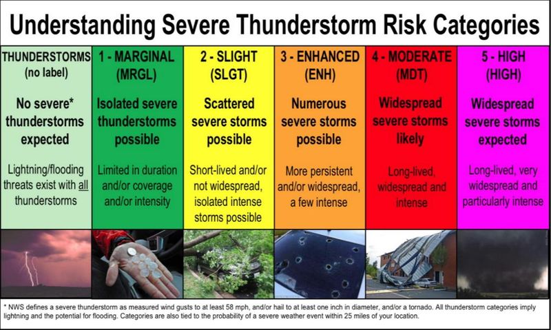
A slight risk is the second level of severe thunderstorm risk categories the National Weather Service uses to communicate the likelihood an area is to see a severe storm. The storms themselves still pose a threat, according to the NWS.
Under a slight risk, the Pensacola is likely to see severe storms, but they will be limited in scope and coverage.
Wednesday’s atmosphere is currently unstable, and there is plenty of energy that could be used to spur strong storms with the right triggers. The good news is that low winds won’t give potential storms the chance to organize and rotate, according to the NWS.
The bad news is that the atmosphere contains enough moisture, and the storms are slow-moving enough to create some localized water issues in areas with poor drainage.
Understanding the National Weather Service’s severe storm risk categories
The National Weather Service’s Storm Prediction Center categorizes storm risk using five levels. Each level represents the extent of an area’s risk and the corresponding degree.
This article originally appeared on Pensacola News Journal: Santa Rosa County now under severe thunderstorm warning
Reporting by Brandon Girod, Pensacola News Journal / Pensacola News Journal
USA TODAY Network via Reuters Connect