The National Weather Service in Milwaukee-Sullivan issued a Tornado Warning for Northern Milwaukee County in southeastern Wisconsin until 7:15 p.m. At 6:33 p.m. CDT, a severe thunderstorm capable of producing a tornado was located over Lannon, or over Sussex, moving east at 30 mph.
The National Weather Service said: Flying debris will be dangerous to those caught without shelter. Mobile homes will be damaged or destroyed. Damage to roofs, windows, and vehicles will occur. Tree damage is likely. This dangerous storm will be near, Milwaukee, Wauwatosa, Brown Deer, Elm Grove, Glendale, and River Hills around 6:40 p.m. CDT. Whitefish Bay, Fox Point, and Bayside around 6:45 p.m. Other locations impacted by this tornadic thunderstorm include State Fair Park, Marquette University, Maier Festival Park, Shorewood, UW-Milwaukee, Mitchell Park Domes, Milwaukee Co Zoo, and AmFam Field. Other landmarks included are the following Locations Schlitz Audobon Nature Center, Timmerman Airport, Froedert & the Medical College, Fiserv Forum, and Port of Milwaukee. Follow Journal Sentinel live updates of severe weather.

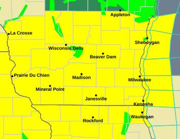
The National Weather Service issued the tornado watch around 2:30 p.m. for portions of southern Wisconsin, northern Illinois and central to eastern Iowa and lasts until 10 p.m. The forecast includes the possibility of several tornadoes, wind gusts up to 75 miles per hour and up to softball-sized hail.
The weather system could bring tornadoes at an EF2 rating or higher and over 8.5 million people live over the area it will move across, according to the National Weather Service.
Weather conditions like this, and the week’s recent 70-degree days, are unusual so early in the year, said Kevin Wagner, a meteorologist at the Sullivan office of the National Weather Service.
“Things are really just kind of coming together with it,” Wagner said.
The storm system has already produced a tornado in Iowa and is moving east as the day goes on. As it moves into Wisconsin, it’s shifted into two main corridors of storms in central Wisconsin and southern Wisconsin.
Weather conditions are forecasted to begin in Milwaukee around 6 p.m. and conditions could last through midnight but by time that happens, the system may shift into a single “line,” where severe winds would be the main threat, Wagner said.
National Weather Service meteorologist J.J. Wood previously told the Journal Sentinel people in the path of the storm should have multiple ways to receive weather alerts.
“Today is one of those days you really want to pay attention to the forecast and stay weather-aware,” Wood said.
The tornado watch comes in the aftermath of severe weather moving across the state on April 13.
The week’s weather system already brought one confirmed tornado to the state, with one touching down in Taylor County the evening of April 13. It also brought strong winds to Milwaukee, where a car was crushed by a falling tree and a billboard was ripped from a building.
The National Weather Service has also issued long-range flood warnings for parts of the state and for a few areas close to Milwaukee, like the Sheboygan River.
Wisconsin weather radar
Wisconsin weather warnings
David Clarey is a public safety reporter at the Milwaukee Journal Sentinel. He can be reached at dclarey@usatodayco.com.
This article originally appeared on Milwaukee Journal Sentinel: Tornado warning issued for Milwaukee
Reporting by David Clarey, Milwaukee Journal Sentinel / Milwaukee Journal Sentinel
USA TODAY Network via Reuters Connect