
Rain and mild temperatures are on their way to the Milwaukee area this week.
However, nothing as severe as last week’s thunderstorms, damaging winds and tornadoes are expected, said John Gagan, a meteorologist with the National Weather Service in Milwaukee/Sullivan.

After a band of showers moved through early in the day Tuesday, June 16, the weather should stay dry for most of the morning in the Milwaukee area, Gagan said.
“We will, this afternoon, start to see scattered showers and a few thunderstorms – it’s kind of hit or miss,” he said. “It’s not going to be a washout or anything like that, but there’s going to be some times where there’ll be some showers moving through, maybe a rumble of thunder.”
The storms will end by sunset June 16, Gagan said. Highs during the day will be in the upper 60s and lower 70s.
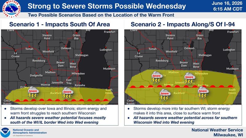
More rain and thunderstorms – as well as a dip in temperature, with highs in the 60s – are coming to southeastern Wisconsin Wednesday, June 17.
“It looks like right now, the highest risk for severe weather is down across Iowa, Illinois and into Indiana. But there could be a few storms across far southern Wisconsin, putting down some gusty winds or some hail the size of quarters,” Gagan said.
But even the parts of Wisconsin that may get hit with strong storms Wednesday shouldn’t expect a severe or long-lasting weather concern.
“Nothing like last week,” Gagan said.
The rest of the week should be mostly dry, he said, with potential for a couple rain showers north of Milwaukee, toward the Fond du Lac and Sheboygan area Thursday, June 18.
Contact Kelli Arseneau at (920) 213-3721 or karseneau@gannett.com. Follow her on X at @ArseneauKelli.
This article originally appeared on Milwaukee Journal Sentinel: Scattered showers and mild thunderstorms are coming to Milwaukee this week
Reporting by Kelli Arseneau, Milwaukee Journal Sentinel / Milwaukee Journal Sentinel
USA TODAY Network via Reuters Connect
By Kelli Arseneau, Milwaukee Journal Sentinel | USA TODAY Network