While the Pacific hurricane season is running about a month ahead of schedule — already producing five named storms and two hurricanes — the Atlantic basin is off to a slow start, remaining relatively quiet despite earlier forecasts calling for an active season.
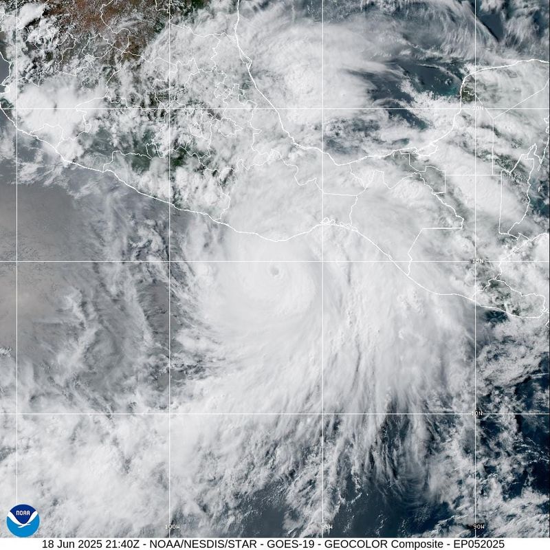
A day after surging to Category 4 status and then hitting Mexico on June 19 as a powerful Category 3 hurricane with maximum sustained winds of 125 mph, Erick has dropped down to a low-pressure area in the Pacific, according to the National Hurricane Center.

Erick made landfall between Acapulco and the resort town Puerto Escondido early Thursday morning, the Associated Press reported, leaving damaged roads, localized flooding, widespread power outages and at least one person dead, a 1-year-old child whose mother had attempted to cross a swollen river.
Are any storms brewing in the Atlantic? NHC tracking 4 waves
The National Hurricane Center is monitoring four tropical waves, including one in the eastern Caribbean:
What is a tropical wave?
A tropical wave — also called an easterly wave — is an elongated area of relatively low pressure, or inverted trough, that travels from east to west across the tropics, according to the National Hurricane Center. While not all tropical waves develop further, they often serve as the initial disturbance that can lead to the formation of a tropical cyclone.
For instance, last year’s Category 5 Hurricane Beryl — one of the top 10 costliest and deadliest storms to hit Texas — began as a tropical wave that emerged off the coast of Africa in late June.
When is the Atlantic’s first named storm on average?
June 20 marks the average date for the first named storm in a typical Atlantic hurricane season. On average, the first hurricane forms by August 11, and the first major hurricane appears in early September.
As of now, no favorable conditions for tropical development are expected through the end of June.
Why are the tropics so quiet in the Atlantic?
Although conditions are quiet for now, AccuWeather lead hurricane expert Alex DaSilva warns the season could ramp up as it approaches its peak.
So far, strong wind shear and an abundance of Saharan dust have helped suppress activity in the Atlantic. Both factors limit tropical development by disrupting storm organization and cutting off the moisture needed for systems to grow.
There are “no concerns in the Atlantic for at least the next seven days. There is too much dry air and the wind shear is too high,” DaSilva said. “If anything develops in June it would likely be in the Bay of Campeche or far western Caribbean, where the shear is a little lower.”
“I think once we get more into the heart of the season, things could get very active. Expect a second-half loaded season.
Contributing: C.A. Bridges and Cheryl McCloud, USA TODAY Network-Florida
This article originally appeared on Austin American-Statesman: NHC monitoring 4 tropical waves as Atlantic hurricane season starts off quiet. See where
Reporting by Brandi D. Addison, Austin American-Statesman / Austin American-Statesman
USA TODAY Network via Reuters Connect