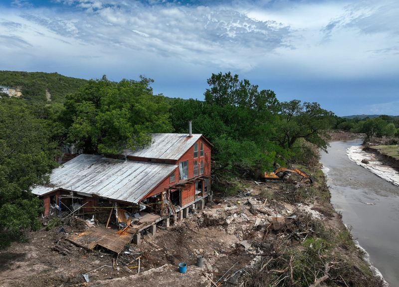
Weather forecasters and emergency response officials knew a storm was headed for Central Texas on July 4 and took steps to prepare for it. Yet somehow, they were caught flat-footed.

Forecasts by the National Weather Service predicted significantly less rainfall than actually fell on Kerr County in the Texas Hill Country. And the agency’s early predictions had the storm hitting hardest near the Rio Grande.
Two days before the flood, the Texas Division of Emergency Management, TDEM, mobilized high-water vehicles, helicopters, rescue boats and personnel. But because officials weren’t sure where the storm would deal its harshest blows, most of those assets were staged in San Antonio, not in the Hill Country towns where they would be needed most desperately, the head of the Texas Department of Public Safety said after the storm.
Early on the morning of July 4, NWS alerts began to light up the cellphones of people in the path of the Guadalupe River’s floodwaters. Yet those warning weren’t urgent — until, suddenly, they were. By then, water was swamping low-lying cabins at Camp Mystic, where 27 campers and counselors died.
Here is an overview of the predictions and preparations made in advance of the flood:
Early forecasts predict moderate rainfall and heightened flood risk, but are unclear about severity and precise location of storms
July 1, afternoon: The National Weather Service office for the San Antonio-Austin region forecasts rain for Wednesday through Friday, but mainly in the western part of its coverage area, near the Rio Grande. For Kerrville, the forecast calls for a 20% chance of rain on Thursday and 30% on July 4.
July 2, afternoon: In a radar update, the NWS says “scattered moderate to heavy showers” are expanding into the Hill Country.
July 2, evening: In response to “increased threats of flooding” over the July 4 weekend, the TDEM activates emergency response teams for Central and West Texas. W. Nim Kidd, chief of TDEM, would later say that emergency personnel were “on the ground” by July 3. It’s unclear precisely where they were deployed. Freeman Martin, director of the Texas Department of Public Safety, said resources had been staged in San Antonio “for the most part,” because of uncertainty over where they would be needed.
July 3, 12:03 p.m.: The NWS posts on X that rain showers are “increasing in coverage” in South and Central Texas. It forecasts scattered showers with “some locally heavy downpours.”
Officials issue flood watch, escalate emergency preparedness advisories as forecasts show heavier rainfall concentrating in the Hill Country
July 3, 1:18 p.m.: The NWS issues a flood watch until 7 a.m. Friday for Kerr County and eight other counties In the NWS lexicon, a “watch” means conditions are favorable for dangerous weather. The agency says 1 to 3 inches of rain is possible and 5 to 7 inches cannot be ruled out.
July 3, 2:26 p.m.: TDEM raises the readiness status of its emergency operations center to Level II, known as “escalated response.” Jay Hall, the agency’s assistant chief, “personally” contacts local officials to make them aware of the potential for flooding, according to an account provided a day later by Lt. Gov. Dan Patrick.
July 3, 4:45 p.m.: The NWS warns on X that showers and thunderstorms continue to form in the region, with potential for “torrential rainfall and gusty winds.”
July 3, 6:51 p.m.: The NWS says “shower activity is increasing across the Hill Country” and was “expected to continue throughout the evening.”
July 4, 12:53 a.m.: The weather service issues a flood watch spanning 11 counties in South Texas, including Kerr County.
July 4, 1 a.m.: The NWS reports “very heavy rainfall rates over parts of the Hill Country,” especially in Bandera, Kerr and Gillespie counties, where 2 to 3 inches per hour is “likely to occur.”
First flash flood warning issued in Kerr and Bandera counties. Within two hours, NWS declares an ongoing dangerous flooding event
July 4, 1:14 a.m.: The weather service issues a flash flood “warning,” as distinct from a watch, for central Kerr County and northwestern Bandera County. It says “life-threatening” flooding is possible. An NWS warning means dangerous weather is happening or is extremely likely to happen soon. Warnings are delivered on social media, by email and directly to cellphones enabled to receive them.
Shortly after the warning goes out, the NWS Weather Prediction Center says parts of the Hill Country could get 6 inches of rain over the next six hours and “some flash flood impacts could be significant.” Forecasters say an additional 6 to 12 inches fell after the warning was issued.
July 4, 3:06 a.m.: The NWS says on X that a “very dangerous flash flooding event is ongoing” in south-central Kerr County and northwest Bandera County.
Summer camps along the Guadalupe River, including Camp Mystic, are rapidly flooded
July 4, 3:11 a.m.: A staffer at Camp Mystic, located near Hunt in western Kerr County, starts to evacuate campers from their cabins, according to an account the staffer posted later on social media. “By 4 a.m., I was on a roof with the water right up to me,” the staffer wrote.
July 4, 3:19 a.m.: The weather service issues a flood warning for the Guadalupe River in Hunt, an area dotted with summer camps. “Minor flooding is occurring and moderate flooding is forecast.” Automobiles were being swept into the river near Camp Waldemar, the agency said. “Some residents are cut off and should stay put.” The NWS says the Guadalupe could reach a height of 16.6 feet at Hunt. Fourteen minutes later, it was at 22 feet.
July 4, 3:30 a.m.: In Kerrville, 12 miles east downriver of Hunt, City Manager Dalton Rice goes jogging along the Guadalupe while crews set up equipment for the annual “Kerrville’s Fourth on the River” celebration at Louise Hays Park. Rice would say later that he saw no indication the river was rising.
July 4, 3:33 a.m.: The NWS issues a flood warning for the Guadalupe in Kerrville.
July 4, 4 a.m.: The NWS issues another flood warning for the Guadalupe at Hunt, saying flooding had progressed from “moderate” to “major” severity.
Flash flood emergency declared as Guadalupe rises to 28 feet of water
July 4, 4:03 a.m.: The weather service heightens its flash flood warning for central Kerr and northwest Bandera counties, calling it a “flash flood emergency” and urging residents, in all caps, to “SEEK HIGHER GROUND NOW!”
July 4, 4:10 a.m.: The Guadalupe at Hunt rises to 22.85 feet, surpassing the 22-foot level that qualifies as a major flood.
July 4, 4:33 a.m.: The city of Kerrville posts road closures on Facebook and says Kerrville police and firefighters are assisting in high-water rescues.
July 4, 5:18 a.m.: The NWS extends its flash flood warning for the Guadalupe at Kerrville, noting that the river had risen to 28 feet, almost as high as during the catastrophic flooding of July 1987.
July 4, 5:34 a.m.: On X, the NWS declares a “flash flood emergency” along the river between Hunt and Center Point. The designation signals an ongoing catastrophic event.
July 4, 5:34 a.m.: The weather service issues a flash flood warning for east-central Kerr County, saying rain gauges have detected a “large and deadly flood wave … moving down the Guadalupe River.”
Guadalupe River evacuations continue as Kerrville mayor declares a state of emergency
July 4, 5:58 a.m.: The city of Kerrville opens an emergency shelter at First United Methodist Church.
July 4, 6:22 a.m.: The city of Kerrville says on Facebook that “severe weather” could disrupt the city’s July 4 celebration. “Much needed rain swept through Kerrville overnight, but the downside is the severe weather may impact many of today’s scheduled July 4 events.”
July 4, 6:29 a.m.: The Kerrville Police Department urges all residents near the Guadalupe to evacuate. “This is a life threatening event. Do not wait,” the department says on Facebook.
July 4, 8:43 a.m.: The city of Kerrville says on Facebook that Mayor Joe Herring Jr. has declared a “local state of disaster” under Texas law.
This article originally appeared on Austin American-Statesman: Ahead of Texas floods, weather warnings weren’t frantic — until suddenly they were
Reporting by Richard Webner / Austin American-Statesman
USA TODAY Network via Reuters Connect