This is one winter storm that is living up to its hype.
As much as a foot of snow could fall across Greater Akron from Winter Storm Fern this weekend.

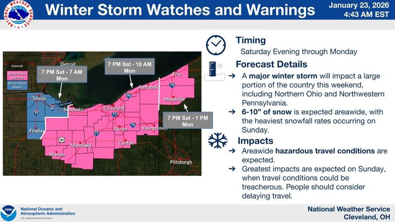
The National Weather Service has issued a winter storm warning for the region starting at 7 p.m. Saturday through 10 a.m. Monday.
The first ingredient of the storm has already arrived.
Bitterly cold Arctic air is settling in across Northeast Ohio and isn’t going away anytime soon.
Cold air advisory issued
A cold air advisory was in effect through 7 a.m. Saturday.
Temperatures were expected to drop to the single digits Friday afternoon.
Wind chills of minus 15 degrees are expected.
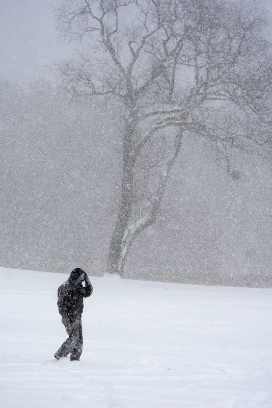
Travel discouraged across Northeast Ohio this weekend
The weather service says this is the first widespread “cross country” winter storm fueled by cold air from the north and moisture from the south to impact such a large swath of the country in four years.
And this is the first storm in recent memory that has the potential to bring at least a half foot of snow to all of Ohio from Lake Erie to the Ohio River.
The weather service is “strongly” discouraging travel in Northeast Ohio during the storm.
Watch for cancellations, altered plans
The storm has already prompted some organizers of events scheduled for the weekend to alter plans.
Patrick Scherer, scout executive and CEO of the Great Lakes Council of Scouting America, said they are shortening the festivities at Saturday’s Klondike Derby at Camp Manatoc in Peninsula so troops can make it home before the storm hits.
The annual weekend activities are a chance for scouts to test their outdoor skills amid challenging and wintry conditions.
So far, it is business as usual at the Akron Canton Airport.
Spokesperson Lisa Dalpiaz said Friday there had been no cancellations or delays but “we’ll certainly anticipate some disruptions if the storm comes to fruition.”
The Akron Zoo announced Friday that it will be closed Saturday through Monday because of the storm.
Zoo spokesperson Elena Bell said they plan to reopen at 11 a.m. Tuesday.
Kent State University has canceled classes at all campuses Monday, Jan. 26, due to the expected snow.
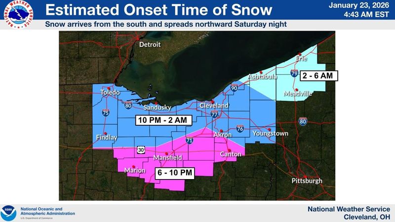
When will the snow start in Akron?
The winter storm has already arrived.
The arrival of the bitter cold on Friday and subzero wind chills are harbingers of the dangerous weather conditions that are expected to quickly deteriorate as the weekend progresses with “heavy” snow expected on Sunday.
The widespread steady snow is expected to arrive in Akron around 10 p.m. Saturday.
Forecasters say the intensity of the snow is expected to increase by 1 a.m. Sunday and continue to “peak” throughout the day before slowly decreasing by Monday morning.
Since it is so cold, forecasters say it will be a dry powdery snow − not great for making snowmen but perfect to create blustery conditions.
“Since this will be a widespread and long duration snow, travel will be heavily impacted everywhere with snow covered roads,” the weather service said.
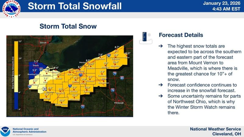
How much snow will fall in Greater Akron?
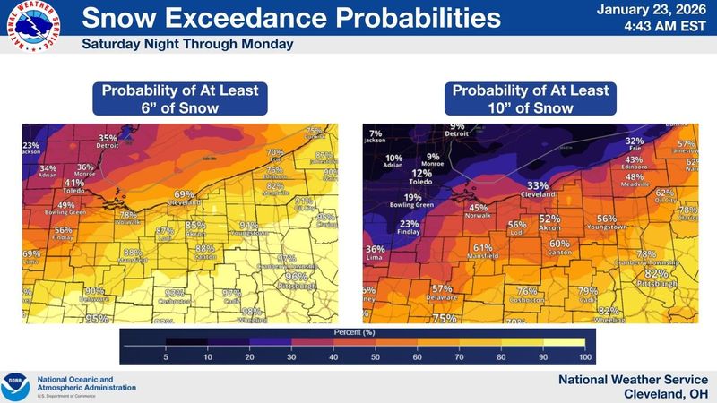
The weather service says anywhere from 6 to 10 inches of snow are expected across Greater Akron.
There is the potential for a foot or more of snow if the storm tracks a bit more north.
Since the Arctic air has settled over Northeast Ohio, forecasters say the region should be spared from the anticipated freezing rain that will plague parts of the country.
How cold will it get in Greater Akron?
The Arctic air will keep things pretty frigid.
Temperatures will be in the single digits Saturday night.
At the height of the snow on Sunday, temperatures are expected to rise to the 20s but quickly fall to the single digits by Monday morning with another round of dangerous wind chills.
“Anyone traveling should have a winter weather kit with warm blankets, food, water and portable chargers since the extreme temperatures will worsen the impacts for stranded motorists,” the weather service said. “Travel is strongly discouraged for this event.”
Akron shelters plan for cold
Akron officials have extended warming center hours at the Summit Lake Community Center, at 380 W. Crosier St., through Tuesday, Jan. 27.
The center will be open from 8 a.m. to 7 p.m. to provide a warm place for those hoping to escape the frigid elements.
For overnight relief, the Emergency Overnight Warming Center at 111 E. Voris St. is open nightly from 7 p.m. to 8 a.m. through Friday, Jan. 30.
Officials say the center will evaluate temperatures daily and extend operations as needed given the prolonged period of dangerous cold ahead.
When will it warm up in Greater Akron?
Those hoping for spring-like temperatures will have to wait.
The National Weather Service says the Arctic chill will hang around through next week with highs in the teens and lows at or near 0.
Wind chills at or near 15 degrees below zero are possible once again Sunday night into Monday morning.
And a series of cold fronts expected next week will bring more widespread light snow.
Akron weather radar map
Akron Weather Forecast
Friday: A slight chance of snow before noon. Partly sunny, with a temperature falling to around 4 by 5 p.m. Wind chill values as low as -11. Northwest wind 11 to 14 mph, with gusts as high as 25 mph. Chance of precipitation is 20%.
Friday night: Partly cloudy, with a low around -4. Wind chill values as low as -11. Northwest wind 5 to 8 mph becoming calm in the evening.
Saturday: A slight chance of snow after 4 p.m. Mostly cloudy, with a high near 12. Wind chill values as low as -3. Calm wind becoming east around 5 mph in the afternoon. Chance of precipitation is 20%.
Saturday night: Snow, mainly after 1 a.m. Low around 8. Wind chill values as low as -1. East wind 5 to 8 mph. Chance of precipitation is 90%. New snow accumulation of 1 to 2 inches possible.
Sunday: Snow. High near 21. East wind 7 to 9 mph, with gusts as high as 20 mph. Chance of precipitation is 100%. New snow accumulation of 3 to 7 inches possible.
Sunday night: Snow. Low around 11. Chance of precipitation is 90%. New snow accumulation of 1 to 3 inches possible.
Monday: A chance of snow before 1 p.m. Mostly cloudy, with a high near 17. Chance of precipitation is 50%.
Monday night: Mostly cloudy, with a low around 0.
Tuesday: Mostly cloudy, with a high near 17.
Tuesday night: Mostly cloudy, with a low around 5.
Wednesday: A chance of snow. Mostly cloudy, with a high near 17. Chance of precipitation is 30%.
Wednesday night: Mostly cloudy, with a low around 2.
Thursday: Mostly cloudy, with a high near 14.
Akron weather hourly
Need to know weather conditions by the hour? Make sure to check out our weather page here.
This article originally appeared on Akron Beacon Journal: Winter storm warning in effect for Northeast Ohio through weekend
Reporting by Craig Webb, Akron Beacon Journal / Akron Beacon Journal
USA TODAY Network via Reuters Connect