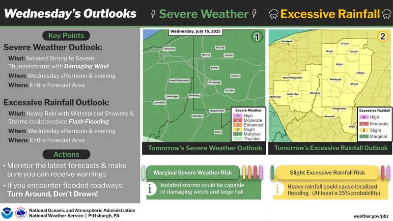
Heavy storms are expected in the region and carry a risk of flooding in the Coshocton County area.
The National Weather Service issued a hazardous weather outlook in the Coshocton County area for storms expected July 16 that could lead to isolated flash flooding.

“Widespread showers and thunderstorms through tonight can produce heavy rain that may result in flash flooding,” the outlook notice stated, adding a flood watch may be needed.
In Coshocton County, the coming storm pattern carries a slight risk of excessive rainfall, a 2 out of 4 on the agency’s metric for excessive rainfall risk.
What should I do in the event of a flash flood?
Here’s the course of action the National Weather Service recommends in the event of a flood:
What’s the forecast for the Coshocton area?
This Afternoon
Showers and thunderstorms. High near 85. Southwest wind around 7 mph. Chance of precipitation is 80%. New rainfall amounts between a quarter and half of an inch possible.
Tonight
Showers and thunderstorms, mainly before midnight. Low around 71. Southwest wind 3 to 5 mph. Chance of precipitation is 80%. New rainfall amounts between a tenth and quarter of an inch, except higher amounts possible in thunderstorms.
Thursday
A chance of showers and thunderstorms between 8am and 2pm, then showers and possibly a thunderstorm after 2pm. High near 86. West wind 6 to 9 mph. Chance of precipitation is 90%. New rainfall amounts between a tenth and quarter of an inch, except higher amounts possible in thunderstorms.
Thursday Night
Showers and possibly a thunderstorm before 8pm, then a chance of showers and thunderstorms, mainly between 8pm and 2am. Low around 66. West wind around 5 mph becoming calm in the evening. Chance of precipitation is 80%. New rainfall amounts between a tenth and quarter of an inch, except higher amounts possible in thunderstorms.
Friday
A chance of showers and thunderstorms, mainly after 8am. Mostly cloudy, with a high near 79. Light northeast wind. Chance of precipitation is 40%. New rainfall amounts of less than a tenth of an inch, except higher amounts possible in thunderstorms.
Friday Night
A slight chance of showers. Patchy fog after 11pm. Otherwise, mostly cloudy, with a low around 64. Chance of precipitation is 20%.
Saturday
A chance of showers, then showers and thunderstorms likely after 2pm. Patchy fog before 9am. Otherwise, mostly cloudy, with a high near 83. Chance of precipitation is 70%.
Saturday Night
Showers and thunderstorms likely before 8pm, then showers likely and possibly a thunderstorm after 8pm. Mostly cloudy, with a low around 69. Chance of precipitation is 70%.
Sunday
A chance of showers and thunderstorms, then showers likely and possibly a thunderstorm after 2pm. Mostly cloudy, with a high near 83. Chance of precipitation is 70%.
Sunday Night
Showers likely and possibly a thunderstorm before 8pm, then a chance of showers and thunderstorms between 8pm and 2am. Patchy fog after 11pm. Otherwise, mostly cloudy, with a low around 64. Chance of precipitation is 60%.
Monday
A chance of showers. Patchy fog. Otherwise, partly sunny, with a high near 82. Chance of precipitation is 40%.
Monday Night
A chance of showers. Patchy fog. Otherwise, mostly cloudy, with a low around 66. Chance of precipitation is 30%.
Tuesday
A chance of showers and thunderstorms. Partly sunny, with a high near 87. Chance of precipitation is 40%.
This article originally appeared on The Repository: Hazardous weather: Isolated flash floods possible in Coshocton County today
Reporting by Janson McNair, Canton Repository / The Repository
USA TODAY Network via Reuters Connect