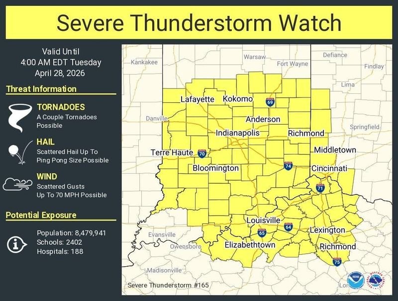
The National Weather Service Office at Wilmington has issued a severe thunderstorm watch for areas of Southeast Indiana, Northern Kentucky and Southwest Ohio until 4 a.m, Tuesday, April 29.
Area affected include:

Watch vs. warning
The difference between a storm watch and a warning can be confusing. Under a watch, forecasters are watching to see if a severe storm will happen, while a warning means there is already a severe storm occurring.
A watch is issued when the risk of hazardous weather increases, but specific details remain uncertain. It serves as a reminder to be alert, as hazardous conditions may occur, giving people time to prepare.
A warning is issued when a hazardous weather is occurring, or is imminent or likely. A warning means weather conditions pose a threat to life or property. People in the path of the storm need to take protective action.
The weather ahead
Monday night: A chance of showers and thunderstorms before 8 p.m, then a chance of showers and thunderstorms between 8 p.m and 9 p.m, then showers and thunderstorms likely between 9 p.m and 11 p.m, then showers and thunderstorms likely between 11 p.m and 1 a.m, then showers and thunderstorms. Mostly cloudy, with a low around 62. South wind 10 to 17 mph, with gusts as high as 29 mph. Chance of precipitation is 100%. New rainfall amounts between three quarters and one inch possible.
Tuesday: A slight chance of showers and thunderstorms before 7 a.m, then a chance of showers and thunderstorms between 7 a.m and 8 a.m, then a slight chance of showers and thunderstorms between 8 a.m and 4 p.m. Partly sunny, with a high near 79. Southwest wind 8 to 14 mph. Chance of precipitation is 30%. New rainfall amounts between a tenth and quarter of an inch possible.
Tuesday night: A chance of showers and thunderstorms between 8 p.m and 2 a.m, then showers and thunderstorms. Mostly cloudy, with a low around 56. North wind 2 to 7 mph. Chance of precipitation is 90%. New rainfall amounts between a half and three quarters of an inch possible.
Wednesday: Showers and thunderstorms. Mostly cloudy, with a high near 67. North wind 3 to 12 mph. Chance of precipitation is 90%. New rainfall amounts between three quarters and one inch possible.
Wednesday night: A chance of showers and thunderstorms before 8 p.m. Partly cloudy, with a low around 44. Northwest wind 3 to 10 mph. Chance of precipitation is 30%. New rainfall amounts less than a tenth of an inch possible.
Thursday: Sunny, with a high near 65.
Thursday night: Partly cloudy, with a low around 44.
Friday: A slight chance of rain showers between 8 a.m and 2 p.m, then a slight chance of showers and thunderstorms. Partly sunny, with a high near 63.
Friday night: A slight chance of showers and thunderstorms before 8 p.m. Mostly cloudy, with a low around 40.
Saturday: Mostly sunny, with a high near 62.
Saturday night: Mostly clear, with a low around 40.
Sunday: Sunny, with a high near 68.
Sunday night: A slight chance of rain showers after 2 a.m. Partly cloudy, with a low around 47.
Monday: A slight chance of rain showers before 8 a.m, then a slight chance of showers and thunderstorms. Mostly sunny, with a high near 72.
Source: National Weather Service in Wilmington
This article originally appeared on Cincinnati Enquirer: Greater Cincinnati, NKY under severe thunderstorm watch. See who’s affected
Reporting by Jennie Key, Cincinnati Enquirer / Cincinnati Enquirer
USA TODAY Network via Reuters Connect