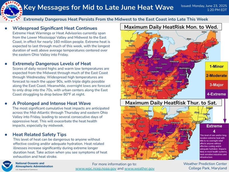
The heat wave continues.
Greater Akron remains under a Heat Advisory through 8 p.m. Tuesday, June 24.

But the National Weather Service says the above-normal temperatures are expected to hang around a bit longer.
There will be some relief, albeit minor, from the above-normal temperatures that settled over northern Ohio starting Sunday as showers and some rumbles of thunder are in the forecast.
Showers and some thunderstorms could arrive as early as Tuesday night and are in the forecast for much of the day on Wednesday with highs in the upper 80s to nearly 90 degrees.
Some of the storms Tuesday night and Wednesday, the weather service says, could be severe with high wind and heavy rain being the main threats.
There’s a chance of rain in the forecast every day, the weather service says through Monday with temperatures in the upper 80s.
Heat wave set records Monday in northern Ohio
Some northern Ohio cities set or tied record highs on Monday.
It hit 94 degrees in Cleveland on Monday tying the record set in 1948.
Mansfield set a new record on Monday when it hit 92 degrees breaking the record set in 1964.
The weather service says it hit 91 degrees Monday in Akron − shy of the record high for June 23 of 94 degrees set in 1923.
The typical highs in Greater Akron this time of year are in the low 80s.
Akron weather radar
What’s the Greater Akron weather forecast?
Tuesday: Sunny, with a high near 95. Heat index values as high as 99. West wind 3 to 7 mph.
Tuesday night: A chance of showers and thunderstorms, mainly before 9 p.m. Partly cloudy, with a low around 74. West wind around 5 mph becoming calm in the evening. Chance of precipitation is 30%. New rainfall amounts of less than a tenth of an inch, except higher amounts possible in thunderstorms.
Wednesday: A chance of showers and thunderstorms, then showers likely and possibly a thunderstorm after 2 p.m. Partly sunny, with a high near 89. Calm wind becoming northwest 5 to 7 mph in the afternoon. Chance of precipitation is 60%. New rainfall amounts between a tenth and quarter of an inch, except higher amounts possible in thunderstorms.
Wednesday night: Showers and thunderstorms likely before 5 a.m., then a slight chance of showers. Mostly cloudy, with a low around 70. Light and variable wind. Chance of precipitation is 60%. New rainfall amounts of less than a tenth of an inch, except higher amounts possible in thunderstorms.
Thursday: A chance of showers before 11 a.m., then a chance of showers and thunderstorms between 11 a.m. and 2 p.m., then showers likely and possibly a thunderstorm after 2 p.m. Partly sunny, with a high near 88. Calm wind becoming west around 5 mph in the afternoon. Chance of precipitation is 60%. New rainfall amounts of less than a tenth of an inch, except higher amounts possible in thunderstorms.
Thursday night: Showers likely and possibly a thunderstorm before 8 p.m., then a chance of showers and thunderstorms between 8 p.m. and 2 a.m., then a slight chance of showers after 2 a.m. Mostly cloudy, with a low around 70. Chance of precipitation is 60%. New rainfall amounts of less than a tenth of an inch, except higher amounts possible in thunderstorms.
Friday: A chance of showers and thunderstorms between 8 a.m. and 2 p.m., then showers likely and possibly a thunderstorm after 2 p.m. Partly sunny, with a high near 90. Chance of precipitation is 60%.
Friday night: Showers likely and possibly a thunderstorm before 2 a.m., then a chance of showers and thunderstorms after 2 a.m. Mostly cloudy, with a low around 71. Chance of precipitation is 60%.
Saturday: A chance of showers and thunderstorms, then showers likely and possibly a thunderstorm after 8 a.m. Partly sunny, with a high near 86. Chance of precipitation is 70%.
Saturday night: A chance of showers before 2 a.m. Mostly cloudy, with a low around 70. Chance of precipitation is 30%.
Sunday: A chance of showers and thunderstorms. Partly sunny, with a high near 90. Chance of precipitation is 50%.
Sunday night: A chance of showers and thunderstorms. Partly cloudy, with a low around 71. Chance of precipitation is 40%.
Monday: Showers likely and possibly a thunderstorm. Partly sunny, with a high near 89. Chance of precipitation is 70%.
Akron weather hourly
Need to know weather conditions by the hour? Make sure to check out our weather page here.
This article originally appeared on Akron Beacon Journal: Extreme heat wave continues with severe storms possible Tuesday, Wednesday in Greater Akron
Reporting by Craig Webb, Akron Beacon Journal / Akron Beacon Journal
USA TODAY Network via Reuters Connect