Storms, high-speed winds, flooding and even a potential tornado has left parts of central Ohio with serious damage, and more disruption may come as a flood watch remains in effect through the morning of Aug. 12 due to extensive rainfall.
A gas station canopy in South Linden could not stand against strong wind gusts, which were recorded to have hit 82 mph at 10:23 a.m. at John Glenn Columbus International Airport as Columbus and other parts of central Ohio were under a severe thunderstorm warning.

The Dispatch spoke to Emergency Management Agency directors from Franklin, Licking, Fairfield and Pickaway counties following heavy storms Aug. 11 to better understand the extent of the damage in their areas, how people can protect themselves from future inclement weather and what steps these directors take to evaluate and map storm damage after the worst of it passes.
Franklin County saw downed power lines, damage along Lockbourne Road
Streets in Upper Arlington and around Kenny and Ackermann roads saw significant damage, said Franklin County EMA director Jeff Young. Additionally, officials had to temporarily shut down Interstate 71 in both directions between Greenlawn Avenue and State Route 104 so crews could remove downed power lines from power poles left tilting from the winds.
“Those are some pretty significant power lines and power poles,” Young said. “So it gives you a good indication of the force of the wind.”
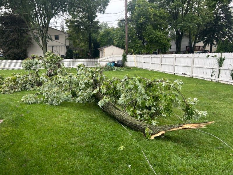
Trees were also knocked down throughout the county, including in places like Columbus’ Clintonville neighborhood, the city’s South Side, Upper Arlington, Hilliard and elsewhere. Some trees lost major limbs in the storm.
Columbus police dispatchers confirmed the intersection of Lockbourne Road and Reeb Avenue was still shut down at 9:30 p.m. Aug. 11 after strong wind and storm damage to vehicles and buildings occurred earlier in the day. A portion of roof was torn off the Dollar General store, a car was flipped over, trees were downed and a food truck was flipped over in that area, according to Dispatch reporting partner NBC4 (WCMH-TV).
Despite how rough the weather conditions were Aug. 11, Young said the most “impactful energy” pushed south of Interstate 70 in the afternoon and evening storms. Despite more storms forecast to come this week, Young said he is hopeful that they won’t have the same energy or volume of forceful winds as those which struck Aug. 11.
As the flood watch still remains in effect, Young recommends that homeowners divert runoff from roofs and hard surfaces away from their home’s foundation.
“You want to make sure that your gutters and downspouts drain away from the structure itself,” Young said.
One of the functions of a county emergency management agency is to conduct damage assessments after a storm passes through, Young said. The agency accounts for the volume of and damage to individual structures and public infrastructure. Those assessments play a part in disaster declarations where federal assistance may become available.
“For Franklin County, our bar is pretty high before we would qualify for any kind of federal assistance,” Young said.
Pickaway County damage largely fallen trees, downed utility poles
In Pickaway County, Island Road in Circleville is still closed due to storm damage, Tiffany Nash, EMA director for Pickaway County, told the Dispatch.
Much of the county’s damage came from fallen trees and downed utility poles. In terms of flooding, Nash said she has not seen any water come over the Scioto River’s banks yet though local streams are swollen.
When dealing with flooding, it is important to turn around. Do not walk or drive through flooding, Nash said. It only takes a couple inches of water to stall a vehicle, and only 6 inches are required to wash away a vehicle.
Additionally, standing puddles could have sharp objects in them, or downed power lines, so it is important to avoid walking through puddles if possible.
If strong winds continue, Nash said it is best to secure any loose objects outside, like patio furniture, toys and light potted plants that can be easily swept up and contribute to debris.
The county is already evaluating damage and speaking to homeowners. Those who have encountered storm damage are encouraged to send information and photos to the Pickaway EMA’s general email inbox at ema@pickawaycountyohio.gov.
Fairfield County had mature trees fall on houses, minor flood threat
In Fairfield County, tree damage was significant, said Jon Kochis, director of Fairfield County EMA.
“I saw today really mature, well-taken-care-of trees, and they had fallen into houses,” Kochis said. “It’s just unfortunate, because we don’t want a world without them.”
While the agency has been monitoring target areas for flooding, only the Pickerington area currently has a minor flood threat.
“That’s good news for as much water as we’ve seen come in the past 48 hours,” Kochis said of the heavy rainfall Aug. 11, must of it in the afternoon-evening series of storms.
Residents can report storm damage to the Fairfield EMA’s website and are encouraged to interact with the agency on social media, Kochis said.
Licking County storm damage was heavier Aug. 10 than Aug. 11
Licking County saw more damage in the morning Aug. 10 than on Aug. 11, John Wieber, Licking County deputy EMA director, told the Dispatch.
On Aug. 10, Wieber noted, a large tree fell into the second story of a house on Hudson Avenue.
As of the evening of Aug. 11, Wieber said Licking County was “sitting pretty good” in terms of possible flooding, but would continue to monitor flood gauges.
To report storm damage, Licking County residents can visit the EMA agency’s website.
Dispatch reporter Nora Igelnik can be reached at nigelnik@dispatch.com.
This article originally appeared on The Columbus Dispatch: County EMA directors evaluate storm damage, monitor flooding
Reporting by Nora Igelnik, Columbus Dispatch / The Columbus Dispatch
USA TODAY Network via Reuters Connect

By Nora Igelnik, Columbus Dispatch | USA TODAY Network