The National Weather Service Office in Des Moines has forecast severe weather across the state starting Thursday, April 2, with greater severity in central and eastern Iowa.
Here’s what to know.

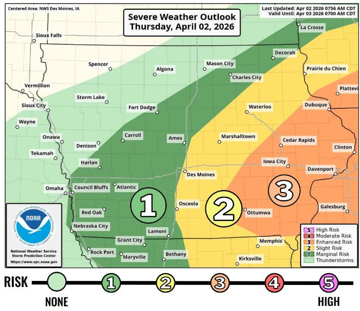
What is the severe weather outlook in Iowa for the next 24 hours?
A slight, or Level 2 (out of 5), risk is in place for much of central Iowa on Thursday, meaning scattered severe storms are possible. In eastern Iowa, a stretch spanning from Ottumwa through Iowa City and up to Dubuque is under a Level 3, or an enhanced risk of damaging storms.
When are severe thunderstorms possible on Thursday?
The strongest storms are expected between 1 p.m. and 6 p.m. in central Iowa, with damaging winds, large hail and tornadoes as the main threats, according to the National Weather Service. Storms will move quickly — around 50 mph — from central into eastern Iowa, with wind gusts up to 70–85 mph posing the greatest risk, along with hail up to 2 inches and an increasing tornado threat east of Interstate 35.
Storms will be out of the central Iowa area after 4 p.m., according to the National Weather Service.
How likely are tornadoes in Iowa on Thursday?
Any tornadoes that do form could reach EF-2 strength.
Des Moines is in the 5-9% probability range for tornadoes. Iowa City and Cedar Rapids are in the highest probability range, at 10-14% odds.
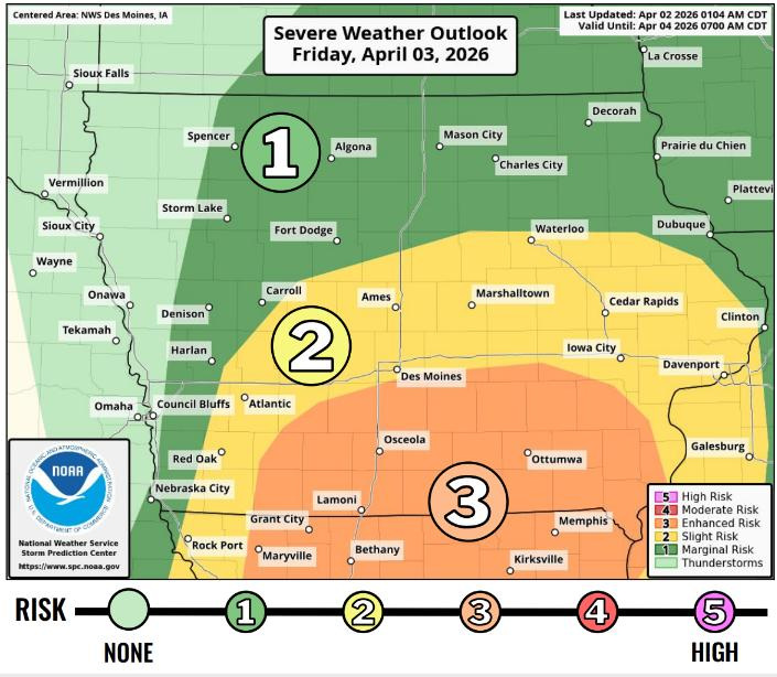
Friday’s forecast brings another round of severe storms in Iowa
Another round of severe weather is expected Friday afternoon and evening, roughly 2 p.m. to 10 p.m., with damaging winds, large hail and tornadoes all possible across much of Iowa.
The highest risk is in southern Iowa, where winds over 70 mph and a greater tornado and hail threat are possible as storms move east‑northeast at around 40 mph
Des Moines weather radar shows rain moving through
Are there severe thunderstorm warnings in Iowa?
Check the map below for the latest weather watches and warnings from the National Weather Service. As of 10:30 a.m. Thursday, no watches or warnings have been issued.
What is the weather forecast in Des Moines?
Showers and possible thunderstorms are expected in Des Moines both Thursday and Friday, with rain likely much of each day. Thursday will be breezy and cloudy, with a high near 66 degrees and rainfall totals up to a half-inch. Wind gusts as high as 26 mph on Thursday night.
Cooler temperatures follow overnight, with lows around 37. Showers and storms continue Friday into Friday night, with highs near 63 and additional rain likely. Winds gusts will peak at 31 mph.
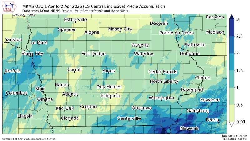
How much has it rained already in Iowa?
Here are the areas that saw the most rainfall over a 24-hour period ending at 10 a.m. Thursday:
Get weather updates
Cooper Worth is a service/trending reporter for the Des Moines Register. Reach him at cworth@gannett.com or follow him on X @CooperAWorth.
This article originally appeared on Des Moines Register: Severe weather forecast in Iowa Thursday and Friday. See the risks:
Reporting by Cooper Worth, Des Moines Register / Des Moines Register
USA TODAY Network via Reuters Connect