For a third straight day, a tornado watch has been issued for a large portion of Iowa.
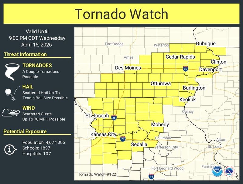
The tornado watch, which covered 43 of Iowa’s 99 counties, will be in effect until 9 p.m. Wednesday, April 15.

The watch includes the Des Moines metro area and areas to the south and east, including Iowa City. Ames is not included in the tornado watch, but is under a severe thunderstorm watch. Portions of Kansas, Illinois and Missouri are included in the tornado watch.
It’s the third day of severe weather in Iowa after storms produced as many as three small tornadoes in northwest Iowa on Monday, April 13, followed by heavy rain and additional tornadoes on Tuesday.
Iowa weather radar
Track the latest storms with the National Weather Service’s Des Moines weather radar:
What are NWS meteorologists saying about tornadoes in Iowa?
At 3:35 p.m. Tuesday, the NWS warned that a couple of tornadoes were possible along with large hail.
The primary threat with the storms is large hail, reaching up to 2.5 inches in diameter, but if supercells continue to develop near each other, tornadoes could also develop in the evening hours.
Iowa weather watches and warnings
How do you stay safe during a tornado?
During a tornado, the National Weather Service recommends:
Remember, tornadoes can move across hills and even bodies of water, so always seek shelter if one is nearby – your elevation or proximity to water are not natural sources of protection.
What should you do if you’re driving during a tornado warning?
If you’re driving, especially on interstates or highways, do not try to outrun a tornado – they can move quickly and change direction without warning.
If a tornado warning is in effect, look for ways to safely leave the road and get out of your vehicle. The safest option is to seek shelter in a sturdy building.
If no building is available, avoid taking cover under a highway overpass. While it might seem protective, overpasses can act as wind tunnels, increasing wind speed and the risk of injury.
Instead, lie flat in the nearest depression, ditch, or culvert and cover your head with your arms.
What is a tornado watch?
A tornado watch means that conditions are favorable for tornadoes to develop in and around the watch area. It doesn’t mean a tornado is occurring, but it signals that the necessary ingredients – such as strong wind shear, atmospheric instability and lift – are present.
When a tornado watch is issued, make sure you have multiple ways to receive weather updates and a safety plan ready in case a tornado warning is issued.
What is a tornado warning?
A tornado warning is a more serious alert, indicating that a tornado is either happening or is about to happen, and you should take shelter immediately.
There are two types of alerts:
Regardless of whether the warning is radar-indicated or confirmed, it is critical to take shelter immediately, as tornadoes can form quickly and radar cannot always capture what’s happening at ground level.
Stay informed. Get weather alerts via text.
This article originally appeared on Des Moines Register: New tornado watch issued for Iowa as third day of severe weather hits
Reporting by Brian Smith and Brandi D. Addison, Des Moines Register / Des Moines Register
USA TODAY Network via Reuters Connect