EVANSVILLE – The National Weather Service still expects a “major severe weather outbreak” in the Tri-State Monday night, so much so that the service says the Evansville area should brace for a “particularly dangerous situation.”

The NWS reserves that language for only the most serious ocassions. And judging from an NWS update Monday afternoon, the evening could reach that threshold.
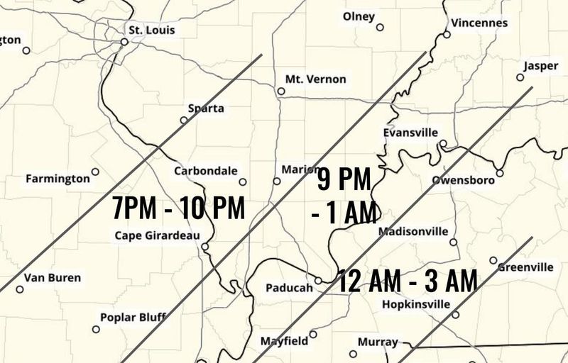
Everything from 70-mile-per-hour straight-line winds, dangerous hail and tornadoes as strong as EF-3 could tear through the area sometime between 8 p.m. and 1 a.m., forecasters said.
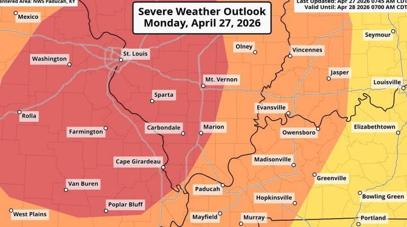
The Paducah, Kentucky office of the NWS has placed Evansville and most of the Tri-State under an “enhanced risk” for severe weather: the third-strongest on the service’s five-point scale. Locales to the west and south face a “moderate risk”: the next step up.
Here’s what we know as of Monday afternoon.
Tornadoes as large as EF-3 possible; Evansville now under a tornado watch
NWS placed most of Southwestern Indiana, Western Kentucky and Southern Illinois under the “particularly dangerous” tornado watch Monday afternoon.
Vanderburgh and most of Henderson County, Kentucky has a 10-14% chance of tornadoes Monday night, the NWS bulletin states. The possibility for severe wind, meanwhile, stands at 45-59%.
Scattered super cells could coalesce into a “powerful squall line” of storms that would create a wall of damaging wind. Any resulting twister could be as large as an EF-3, packing gusts between 136 and 165 miles per hour.
That could result in “major damage to homes, businesses (and) schools,” the NWS stated, as well as “total destruction of manufactured homes, barns, and outbuildings.”
When will the storms arrive?
The NWS puts the Evansville area’s window for severe weather between 9 p.m. and 1 a.m. As of Monday morning, some radar predictions had the storm passing through the metro area between 10 p.m. and 11:30 p.m.
There’s a chance for hail, too
The storms could also spit dangerous hail as large as 2 inches in diameter – just a shade bigger than a golf ball. Vanderburgh County has a 15-29% chance of damaging hail. The chances drop a bit as you move east.
Severity still up in the air
The question forecasters batted around Monday afternoon was whether the atmosphere could recover enough to gin up storms as strong as the forecast.
Parts of the Tri-State already took a moderate beating Monday morning. Scattered storms dumped heavy amounts of rain in short succession and battered cars and crops with pea- to golf-ball-sized hail.
Forecasters said if the area remained cloudy and cool, that could limit the storms’ energy Monday night. However, if the sun came back out, that could recharge things and fuel any potential squalls. As of 4:30 p.m., the sun had started to peek out in parts of the city.
The last time Evansville landed under a “particularly dangerous situation” warning was on March 15. Those storms largely fizzled by the time they reached the city, but did do damage elsewhere.
More storms possible Tuesday
After Monday’s storms move out, another wave could sweep through Tuesday afternoon and evening, although it’s not expected to be nearly as strong.
Still, the back-to-back systems could led to isolated flash flooding. According to the NWS, large swaths of Southwestern Indiana could see as much as 3 inches of rain between now and Tuesday night.
This article originally appeared on Evansville Courier & Press: Weather service: Tri-State could face ‘dangerous situation’ tonight
Reporting by Jon Webb, Evansville Courier & Press / Evansville Courier & Press
USA TODAY Network via Reuters Connect