
EVANSVILLE – Large parts of Indiana and Illinois north of the Tri-State face the potential for dangerous weather on Wednesday, including “intense” tornadoes and tennis-ball-sized hail.
Storms won’t reach those levels here. But the Evansville area could still see severe weather – and at the most dangerous time of day.

Rachel Trevino, a meteorologist with the Paducah, Kentucky office of the National Weather Service, said the southern tail of that monster system could “sink south” late on Wednesday and into the overnight hours Thursday.
What kind of severe weather could Evansville face?
NWS currently has most of Southwestern Indiana under a “slight risk” for severe weather: the second wrung on the service’s five-point scale. Trevino said Evansville’s “main concern” will be damaging wind.
The system will be barrel in from the north, weakening as it crawls down Indiana. That means areas along and north of Interstate 64 could see stronger storms than Evansville itself. That includes the chance for an isolated tornado, Trevino said.
What time will the storms arrive?
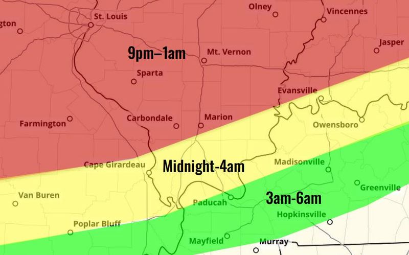
An NWS bulletin released just before 10:30 a.m. showed the storms hitting the northern edges of the Tri-State anywhere between 9 p.m. and 1 a.m. For Evansville, they’ll likely sweep into town between midnight and 4 a.m., while most people are asleep.
That makes any severe threat inherently more dangerous. Trevino urged everyone to have a way to receive storm alerts.
Terrible weather to our north
Whatever Evansville and the Tri-State receives, it shouldn’t be anywhere as serious as what areas to the north are staring down.
According to NWS’ Storm Prediction Center, everywhere from Chicago to Northwestern Indiana to Southern Michigan could see gargantuan hail and wind gusts as strong as 75 miles per hour. Some storms will comb over the same areas multiple times, sparking the possibility of flooding.
Indianapolis and Bloomington could be at risk as well, although the system will dissipate more and more as it dips south.
“Right now we’re focusing across north central Illinois and northwest Indiana. That appears to be the area for the greatest concern,” SPC meteorologist Jared Guyer told the New York Times.
Evansville weather radar
This article originally appeared on Evansville Courier & Press: Evansville may see parts of ‘intense’ weather hitting Midwest
Reporting by Jon Webb, Evansville Courier & Press / Evansville Courier & Press
USA TODAY Network via Reuters Connect
By Jon Webb, Evansville Courier & Press | USA TODAY Network