Chances for a tropical system to develop continue to increase, although there is a bit of good news for Florida over the Fourth of July holiday weekend, according to forecasters.
Well, maybe not great news if rain over a holiday weekend isn’t your thing.

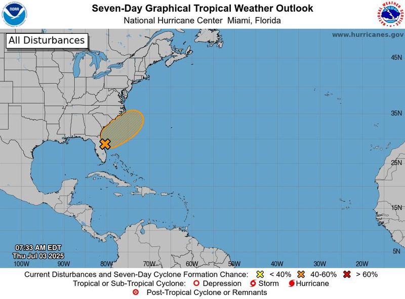
An area near the U.S. coast is being monitored for slow tropical development in the coming days. The large area of interest is located a few hundred miles to the east of Florida’s Space Coast, according to AccuWeather.
➤ Track all active storms
➤ Weather alerts via text: Sign up to get updates about current storms and weather events by location
The system has a 60% chance for development over the next seven days and 20% chance over the next 48 hours.
The good news is that forecasts call for potential development to occur in the Atlantic, instead of in the Gulf, which could have sent the system over Florida.
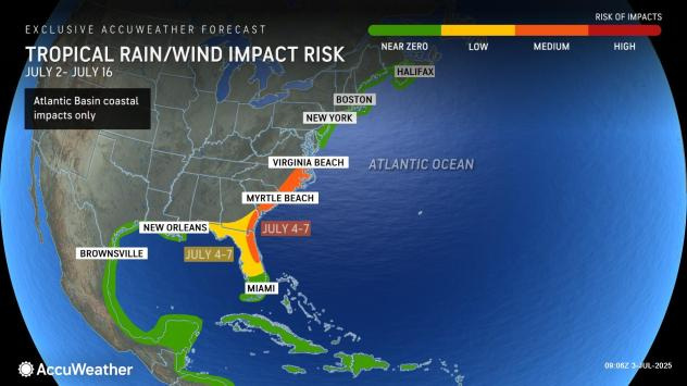
Current forecasts call for the system of low pressure to develop near Florida or off the southeastern coast of the United States over the Fourth of July holiday weekend, or even early next week, the National Hurricane Center said. It’s then expected to drift north or northeast, away from Florida.
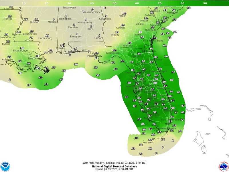
Regardless of development, the system could bring up to 6 inches of rain to some portions of Florida through the Fourth of July weekend, according to the National Weather Service.
The next named storm of the 2025 Atlantic hurricane season will be Chantal.
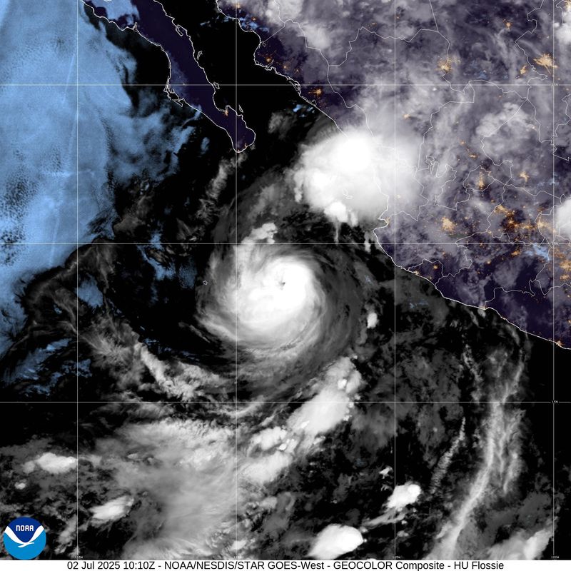
In the eastern Pacific, Flossie has weakened into a tropical storm as it moves away from Mexico.
Here’s the latest advisory from the National Hurricane Center as of 8 a.m. July 3:
Is a tropical storm or hurricane coming toward Florida?
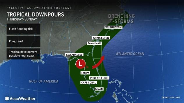
An area of low pressure is forecast to develop along a weakening frontal boundary near Florida or the Atlantic coast of the southeastern United States by Saturday, according to the National Hurricane Center.
Environmental conditions appear only marginally conducive for some slow development, but a tropical or subtropical depression could form in this region over the weekend or early next week while the systemdrifts northward or northeastward.
Regardless of development, heavy rainfall is possible across portions of the southeast U.S., particularly across the west-central Florida coast.
Will a tropical system impact Florida over July 4th holiday weekend?
“Regardless of development, heavy rainfall is possible across portions of the southeast U.S., particularly across West-Central Florida,” the Florida Department of Emergency Management said.
“Those heading to the beaches for the holiday weekend from northern Florida and the Alabama and Mississippi panhandles to the Carolinas are urged to monitor the forecast, as there may be rough surf and rip currents and perhaps gusty winds should a tropical depression or storm develop,” said Alex DaSilva, AccuWeather lead hurricane expert, adding, “We feel the development window is from around July 4 to early next week.”
“From July 4 through early next week, conditions will favor rounds of drenching thunderstorms from parts of Florida to the coastal Carolinas, fueled by tropical moisture and lingering atmospheric instability,” AccuWeather said.
Ocala weather forecast for July 4 and the holiday weekend
According to the National Weather Service, the high temperature on July 4 will be 88 degrees and there is a 90% chance of rain during the day and an 80% chance at night.
The rain chances are 80% on July 5 and 70% on July 6.
4th of July fireworks and events for Ocala and surrounding area
Check this list for all the details.
Where could potential tropical system go?
The system of low pressure expected to develop over the holiday weekend is being squeezed between a high-pressure system moving east from the Ohio Valley and the Bermuda High over the central Atlantic, according to AccuWeather.
“Which high ends up exerting more influence may determine the track of the tropical area of interest, should it develop,” DaSilva said.
“If the Bermuda high is stronger, it could push the tropical feature close to the U.S. coast and potentially shorten the development window.
“On the other hand, should the high building in from the Midwest be stronger, it could shunt the tropical feature more offshore over the Atlantic, where it might have more time to evolve and strengthen.”
Where is Flossie?
Flossie has weakened and is now a tropical storm with 60-mph winds, according to the National Hurricane Center at 2 a.m. MST.
Steady weakening is expected during the next day or so, with the system forecast to become a post-tropical remnant low later July 3.
Flossie is expected to move toward the west-northwest at 9 mph.
Flossie spaghetti models
This forecast track shows the most likely path of the center of the storm. It does not illustrate the full width of the storm or its impacts, and the center of the storm is likely to travel outside the cone up to 33% of the time.
Tropical Storm Flossie tracker, path
This forecast track shows the most likely path of the center of the storm. It does not illustrate the full width of the storm or its impacts, and the center of the storm is likely to travel outside the cone up to 33% of the time.
What do the colored, hatched areas on the NOAA map mean?
The hatched areas on the National Hurricane Center’s tropical outlook map indicate “areas where a tropical cyclone — which could be a tropical depression, tropical storm or hurricane — could develop,” said National Hurricane Center Deputy Director Jamie Rhome.
The colors make it visibly clear how likely a system could develop, with yellow being low, orange medium, and red high.
The National Hurricane Center generally doesn’t issue tropical advisories until there is a named storm, but there is an exception.
“If a system is near land and there is potential for development, the National Hurricane Center won’t wait before it issues advisories, even if the system hasn’t become an actual storm. This gives residents time to prepare,” Rhome said.
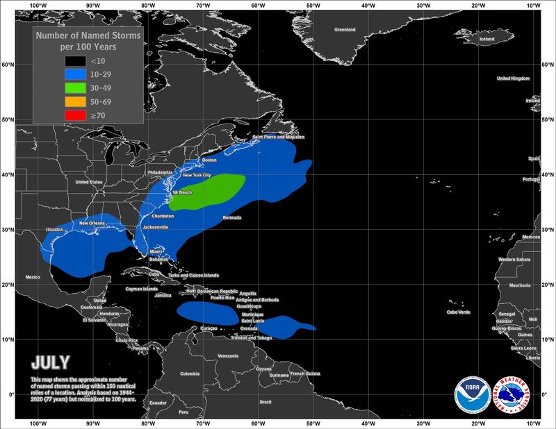
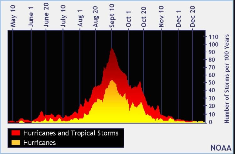
Tropical development common close to Florida in July
Named storms historically develop close to the U.S. in July, especially in the Gulf and off the Atlantic coast between Florida and the Carolinas.
Later in the season, tropical storms and hurricanes develop out of tropical waves moving off the coast of Africa.
NOAA tracking 4 tropical waves, including 1 in Caribbean
Elsewhere in the tropics, the National Hurricane Center is monitoring four tropical waves, including one in the Caribbean. A second wave in the Caribbean on July 2 has moved across Central America and is now in the eastern Pacific:
Florida weather radar for July 3, 2025
Weather forecast for other parts of Florida for July 3, 2025
Florida weather forecast for July 3, 2025
Weather watches and warnings issued in Florida
When is the Atlantic hurricane season?
The Atlantic hurricane season runs from June 1 through Nov. 30.
Ninety-seven percent of tropical cyclone activity occurs during this time period, NOAA said.
The Atlantic basin includes the northern Atlantic Ocean, Caribbean Sea and Gulf of America, as the Gulf of Mexico is now known in the U.S. per an order from President Trump. NOAA and the National Hurricane Center are now using Gulf of America on its maps and in its advisories.
When is the peak of hurricane season?
The peak of the season is Sept. 10, with the most activity happening between mid-August and mid-October, according to the Hurricane Center.
National Hurricane Center map: See what forecasters watching now
Systems currently being monitored by the National Hurricane Center include:
Why does NHC say ‘tropical cyclone’ on its maps instead of hurricane or tropical storm?
Tropical cyclone is the generic term used by the National Weather Service, NOAA and the National Hurricane Center for any tropical system, even if it’s in the tropical Atlantic basin.
To be more precise, a tropical cyclone is a “rotating, organized system of clouds and thunderstorms that originates over tropical or subtropical waters and has closed, low-level circulation,” NOAA sadi.
Once maximum sustained winds reach 74 mph, what it is called is determined by where it originated:
Interactive map: Hurricanes, tropical storms that have passed near your city
Stay informed. Get weather alerts via text
What’s next?
We will update our tropical weather coverage daily.
Download your local site’s app to ensure you’re always connected to the news. And look for our special subscription offers here.
Jim Ross contributed
(This story was updated to include additional information)
This article originally appeared on Ocala Star-Banner: Tropical threat grows near Florida ahead of July 4th weekend. What’s in store for Ocala?
Reporting by Cheryl McCloud, USA TODAY NETWORK – Florida / Ocala Star-Banner
USA TODAY Network via Reuters Connect