
There’s no normal way to do anything now, but the first named storm of the 2026 Hurricane Season is strange even by modern standards.
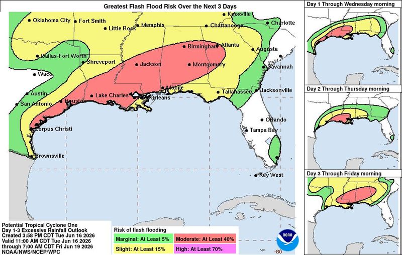
Taking the scenic, overland route to development, Tropical Storm Arthur will grind along the western Gulf Coast through early Thursday before moving inland. As with many early season systems, the key impact of Arthur will be torrential rainfall triggering river and flash flood risks from coastal Texas to the Florida Panhandle and across portions of the Deep South over the next three days.

As of the NHC’s 11 a.m. Wednesday advisory, Potential Tropical Cyclone One has been named Tropical Storm Arthur, defeater of the Saxons, sovereign of all England.
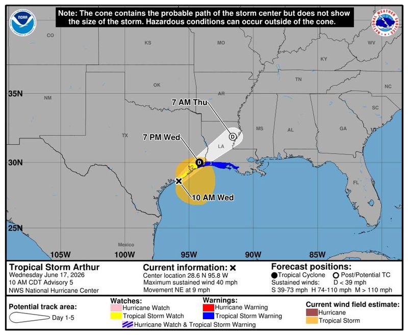
Hurricane Hunters (whose duty is to sample as much peril as they can) investigating Arthur this morning determined it has sustained winds of 40 mph and a defined-enough surface circulation along the Texas Gulf Coast to justify this upgrade.
Look for Arthur to move northeast along the coast towards, oddly enough, Port Arthur on the Texas-Louisiana border over the next 12 to 24 hours.
Arthur should remain a minimal tropical storm through “landfall,” producing coastal gusts of 40 to 55 mph, roughly equal to the air-speed velocity of an unladen European swallow.
These gusts will be found in thunderstorms east of the center along the Central Gulf coast, and Tropical Storm Warnings are in effect from High Island, Texas to Morgan City, Louisiana. The peak wind gust so far this morning has been 55 mph in Galveston. Additionally, onshore flow will result in storm tides a few feet above normal along the west-central and central Gulf Coast through Thursday.
Tropical Storm Arthur’s real threat will be rain, flooding
But just as strange women lying in ponds distributing swords is no basis for a system of government, focusing on this Arthur’s name, track, or maximum sustained winds is not the right way to look at the forecast.
The real threat will be heavy rainfall impacts on the central Gulf Coast and inland South.
Your perspective on this rainfall likely varies based on your location.
Over the past six months, much of Florida and eastern portions of the Southeast have seen half to two-thirds of normal precipitation. When one of the largest lakes in the Panhandle vanishes into a karst pit like a 747 under the cruel tutelage of David Copperfield, we could really use the rain.
Further west, the situation is reversed.
In flood-sensitive coastal Texas, Louisiana, and southern Mississippi, two-month rainfall totals are running anywhere from 150 to 300% of average, with some recent flash flooding even prior to this week’s accumulations.
Arthur looks to both bring additional rainfall to areas where it will be appreciated, and where it is unwelcome. Storm totals over the last few days in Texas and Louisiana are already 3-6” or more, causing flooding issues in low-lying areas and river basins.
That includes the Houston metro area, where Flash Flood Warnings have been intermittently in effect. As of Wednesday morning, Flood Watches are up for southeast Texas to central Georgia and the Florida Panhandle.
Western Florida Panhandle could see 3 to 6 inches of rain
Arthur will remain highly asymmetrical and disorganized for the remainder of its short life due to around 25 knots of westerly wind shear, with little to no precipitation occurring west of the center. Rainfall is wrapping up in south Texas and will taper off in eastern Texas by Wednesday evening.
The heaviest rain over the next two days will focus on eastern Louisiana, southern Mississippi and Alabama, and the western Florida Panhandle, where an additional 3-6” is likely.
Northern Mississippi and Alabama, Georgia, and the eastern Florida Panhandle will also see off-and-on heavy showers through Friday evening. Additional accumulations will be a little lower there, totaling 2-4”.
The remnants of Arthur will move at a gallop east-northeast across the Deep South Thursday and Friday, limiting the upside potential of this precipitation.
Nevertheless, the highest risks of excessive rainfall extend east to roughly Destin, as individual bands may “train” over localized areas and cause flash flooding. Those in low, flood-prone areas along and inland from the central Gulf Coast should carefully monitor weather warnings from your local National Weather Service office over the next few days, as well as tying down your wood, ducks, apples, very small rocks, and anything else that floats.
Florida Big Bend will see beneficial rain, peninsula will see rip currents
East of Destin into Florida’s Big Bend, look for bands of storms to kick up through Friday evening, yielding more persistent round-the-clock rainfall chances than a typical high-coverage day of summer thunderstorms. Rain totals through Saturday will be on the order of a beneficial 1.5-3” in the Tallahassee area, increasing north and west into southern Georgia and Alabama.
The Florida peninsula is likely to remain mostly drier than normal into next week. Southerly winds through Saturday night will also lead to dangerous rip current conditions from southern Mississippi to the Florida Panhandle.
Please heed swimming advisories and water closures; unfortunately, drownings on Gulf beaches occur even in weak tropical storms.
For Florida, storms like Arthur are necessary for balance
It is important to remember that like vultures, sharks, and octopuses that correctly predict World Cup games, tropical cyclones are a misunderstood but essential part of the natural world.
From June to November, 10% to 15% of Florida and the Southeast’s total precipitation comes from named tropical storms and hurricanes. Lacking tropical weather, the entire Southeast would run permanent precipitation and soil moisture deficits, so try to keep the weather’s chaotic neutral alignment (shared by rogues, barbarians, and some bards) in mind as you deal with a rainy few days.
Finally, NOAA officially declared that an El Niño event is underway in the Pacific as of late last week. I planned on discussing the El Niño outlook in depth today, but I’ll take a literal rain check on that to next week. In the meantime, suffice to say that Arthur doesn’t change the overall assessment of a quieter than normal hurricane season ahead.
Of the ten strongest El Niños since 1850, half had at least one U.S. named storm impact in May or June. Wet weirdos in the Gulf are as classically tropical as coconuts early in hurricane season, El Niño or not. Stay dry as we navigate Arthur’s aquatic ceremonies this week, and keep watching the skies.
Dr. Ryan Truchelut is chief meteorologist at WeatherTiger, a Tallahassee company providing forensic meteorology expert witness, agricultural, and hurricane forecasting services. Email Truchelut at Ryan@weathertiger.com.
This article originally appeared on Tallahassee Democrat: Tropical Storm Arthur: Florida forecast calls for beneficial, flooding rain
Reporting by Ryan Truchelut, WeatherTiger / Tallahassee Democrat
USA TODAY Network via Reuters Connect
By Ryan Truchelut, WeatherTiger | USA TODAY Network