
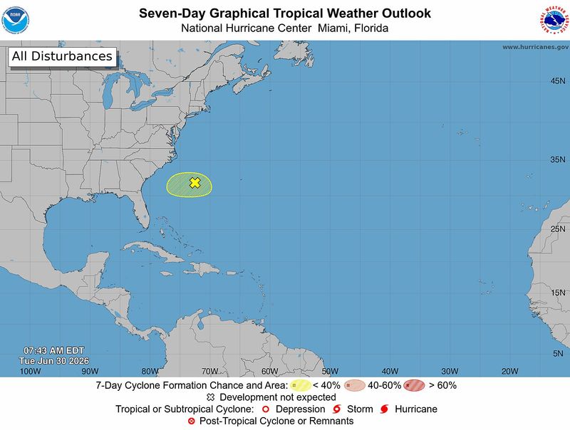
A disturbance in the western Atlantic continues to show little chance for tropical development as the Fourth of July approaches.
➤ Track all active storms

The National Hurricane Center said environmental conditions are “only marginally favorable for some tropical development over the next day or two.”
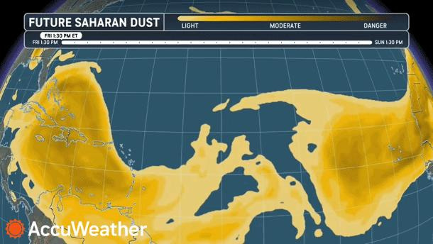
Saharan dust, which helps limit the potential for systems to develop or strengthen, is heading toward the United States.
Shop Amazon for hurricane supplies
“Some of the dust from the first cloud could drift over South Florida this weekend and South Texas early this week,” AccuWeather Senior Meteorologist Dan Pydynowski said.
Last year at this time, all eyes were on Tropical Storm Chantal, which impacted the Fourth of July holiday period in 2025.
Chantal moved across Florida on July 3 — bringing showers and thunderstorms to the state — and strengthened into a tropical depression in the Atlantic east of Florida. Chantal made landfall as a tropical storm near Litchfield Beach, South Carolina, on July 6, 2025, with 51-mph winds, according to the National Hurricane Center.
➤ Weather alerts via text: Sign up to get updates about current storms and weather events by location
As we wait to see if anything develops out of the disturbance currently in the Atlantic, what’s more certain is the heat dome that will impact Florida and a huge portion of the U.S. this week and into the holiday weekend.
Heat advisories have been issued June 30 for 16 counties, all in the Panhandle, a sharp decrease from the 41 heat advisories in effect 24 hours earlier.
In addition, Florida residents shouldn’t be concerned about the four tropical waves out there.
“The first waves that come off Africa are usually too far south, and there’s often too much dry air and wind shear for them to develop,” said Alex DaSilva, AccuWeather lead hurricane expert, via email. “There’s no real concern with these early-season tropical waves.”
The next named storm of the season will be Bertha.
Here’s the latest advisory from the National Hurricane Center as of 8 a.m Tuesday, June 30:
When is hurricane season?
The Atlantic hurricane season runs from June 1 through Nov. 30.
Ninety-seven percent of tropical cyclone activity occurs during this time period, NOAA said.
➤ Hurricane Center testing new cone: What’s changing this season?
The Atlantic basin includes the northern Atlantic Ocean, Caribbean Sea and Gulf of America, as the Gulf of Mexico is now known in the U.S. per an order from President Trump. NOAA and the National Hurricane Center are now using Gulf of America on its maps and in its advisories.
Countdown clock to end of 2026 Atlantic hurricane season
Is there a hurricane coming toward Florida?
No. Forecasters are watching a disturbance in the western Atlantic but, as of June 30, it has a low chance for development this week.
Saharan dust expected to drift across parts of Florida over holiday weekend
Saharan dust is not unusual, and this is the season for plumes of dust to be carried from Africa’s Sahara Desert across the Atlantic by winds.
Two large Saharan dust clouds are headed west from Africa toward the United States, according to AccuWeather.
“Most of the dust is likely to stay aloft rather than fall to the ground when it arrives in the United States, which is good news for health concerns. However, the airborne dust can cause hazy conditions and sometimes colorful sunrises and sunsets.
“Some of the dust from the first cloud could drift over South Florida this weekend and South Texas early this week,” Pydynowski said.
The highest dust concentrations this weekend will be from the Caribbean to the Yucatán Peninsula in Mexico.
National Hurricane Center tracking disturbance in Atlantic
There is one tropical disturbance and four topical waves highlighted by the National Hurricane Center on its tropical outlook as of 8 a.m. June 30.
Tropical disturbance
Offshore southeastern U.S. coast: A weak area of low pressure located along a frontal boundary off the southeastern U.S. coast is associated with limited shower and thunderstorm activity.
Environmental conditions are becoming less conducive for significant development of this system as it drifts southward and then westward later this week.
Tropical waves
What is a disturbance?
The National Hurricane Center’s tropical outlook map highlights “disturbances” in the Atlantic basin.
These are clusters of storms with some organization, but which don’t have a defined circulation typical of tropical cyclones.
➤ Ready or not, National Hurricane Center resumes daily tropical outlooks
If shown on the tropical outlook map in orange or red, forecasters are predicting the potential of those disturbances into developing as medium or high, respectively.
Disturbances shown on the map with a gray x have little to no chance for development. This is a change from prior years which indicated such disturbances in yellow.
What is a tropical wave?
“Tropical waves are clusters of showers and thunderstorms that act as the seedlings for many tropical storms throughout the Atlantic season,” said Alex DaSilva, AccuWeather lead hurricane expert, via email.
“There are about 60 tropical waves that move across the Atlantic each year, and roughly 10 percent to 15 percent of them develop into a tropical system. That’s about one in seven.
“Tropical waves are important because they contribute to about 80 percent of all major hurricanes.”
What do the colored, hatched areas on the NHC map mean?
The hatched areas on the National Hurricane Center’s tropical outlook map indicate “areas where a tropical cyclone — which could be a tropical depression, tropical storm or hurricane — could develop,” said National Hurricane Center Deputy Director Jamie Rhome.
➤ Hurricane Center is testing new cone: What’s changing the season
The colors make it visibly clear how likely a system could develop, with orange medium and red high. In 2026, the tropical outlook will use a gray X to indicate disturbances with a low chance for development.
The National Hurricane Center generally doesn’t issue tropical advisories until there is a named storm, but there is an exception.
“If a system is near land and there is potential for development, the National Hurricane Center won’t wait before it issues advisories, even if the system hasn’t become an actual storm. This gives residents time to prepare,” Rhome said.
A major hurricane is a storm that is a Category 3 or stronger, with maximum sustained winds of at least 111 mph.
How many tropical storms, hurricanes are in a typical season?
The 30-year average, from 1991 to 2020, is for 14 named storms, seven hurricanes and three major hurricanes.
Could Florida be hit by a hurricane in 2026? See which counties have highest chance
Florida weather radar for June 30, 2026
Weather watches and warnings issued in Florida
When is the peak of hurricane season?
The peak of the season is Sept. 10, with the most activity happening between mid-August and mid-October, according to the Hurricane Center.
What are names for 2026 Atlantic hurricane season?
Here are the names for the 2026 Atlantic hurricane season and how to pronounce them:
Interactive map: See how many hurricanes, tropical storms have passed near your home
Stay informed. Get weather alerts via text
What’s next?
We will continue to update our tropical weather coverage to bring you the most current information you need to protect your home and family.
This story has been updated to include new information.
Cheryl McCloud is a journalist for the USA TODAY Network-Florida’s service journalism Connect team. You can get all of Florida’s best content directly in your inbox each weekday day by signing up for the free newsletter, Florida TODAY, at https://tcpalm.com/newsletters.
This article originally appeared on Treasure Coast Newspapers: Tropical disturbance, Saharan dust, heat dome. What else is out there?
Reporting by Cheryl McCloud, USA TODAY NETWORK – Florida / Treasure Coast Newspapers
USA TODAY Network via Reuters Connect
By Cheryl McCloud, USA TODAY NETWORK – Florida | USA TODAY Network