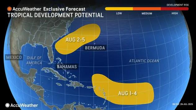
AccuWeather forecasters are watching two areas within the Atlantic for tropical development at the start of August.
The more immediate area of interest is the same area along the southeastern coast of the United States that led to the formation of Tropical Storm Chantal in early July. A slow-moving front is forecast to move into the area and stall between Aug. 2-5.

Weaker disruptive breezes could give the front a low chance of tropical development within the first week of August.
“The good news is that if anything develops, it is likely to move away from the U.S.,” said AccuWeather Lead Hurricane Expert Alex DaSilva.
The stalled front is likely to bring a stormy weather pattern to North and Central Florida between Friday and Tuesday, Aug. 5, regardless of how it develops.
The second area of interest is a tropical wave that originated off Africa’s western coast. The wave is tracking westward and will approach the Lesser Antilles during the middle-to-late parts of the week, according to AccuWeather.
“Conditions are marginal for development between July 30 and Aug. 2 as the wave moves west,” adds DaSilva. “Any interests in the Lesser Antilles will want to keep an eye on this wave as it moves east.”
Signs say 2025 Atlantic hurricane season could ramp up in August
The lack of hurricanes could give off the false impression that the start of the 2025 Atlantic hurricane season has been a slow one. With three named storms already under its belt, we’re actually ahead of schedule, but there are other reasons activity might feel slow.
“Currently, we’re above-normal for named storms but below normal for all other metrics,” said Colorado State University meteorologist Phil Klotzbach in a July 24 e-mail to USA TODAY.
Accumulated Cyclone Energy (ACE), which is a key measurement of the severity of hurricane season, measures the total wind energy produced by a season of tropical storms. The Atlantic hurricane season’s current ACE measurement is the slowest it’s been since 2009.
That could change as we head into August, which tends to be the pivoting point when tropical activity starts to boom.
July saw no shortage of tropical waves, but more robust waves have started popping up toward the end of the month.
“There are some stronger waves starting to show up in the Central Atlantic, but right now, dry and sinking air is making development tough. There’s another wave coming off (Africa) that may have a slight chance of development in about a week or so near the Caribbean Islands,” Andy Hazelton, a University of Miami hurricane scientist, told USA TODAY in an e-mail.
The National Hurricane Center is tracking five tropical waves in the Atlantic, Caribbean
There are five tropical waves in the Atlantic:
Eastern Atlantic tropical wave
Central Atlantic tropical wave
Eastern Caribbean tropical wave
Central Caribbean tropical wave
Western Caribbean tropical wave
This article originally appeared on Pensacola News Journal: The low-energy Atlantic hurricane season could perk up in early August
Reporting by Brandon Girod, Pensacola News Journal / Pensacola News Journal
USA TODAY Network via Reuters Connect