PANAMA CITY — Amid some oppressive heat in our area, some severe storms could be on the way.
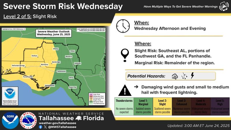
The National Weather Service’s Tallahassee forecasting office announced in a Facebook post that there’s a slight risk of severe storms for Bay County on June 25. This is two out of five on the risk level. Forecasters say the primary concerns are damaging wind gusts, small- to medium-sized hail and frequent lightning.

The storms should roll in during the afternoon and evening hours. The storm prediction center shows a marginal threat, one out of five, persisting through June 26.
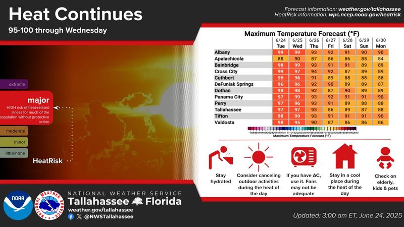
The rough weather comes amid a brutal heat wave. Heat index values on June 24 stood around 107, only expected to climb higher into June 25. NWS Tallahassee put the entire forecast area, including Bay County, under a major heat risk. This means there is a high-risk of heat-related illness for much of the population without protective action.
The meteorologists are saying residents should stay hydrated, consider canceling midday outdoor activities and use air conditioning as opposed to fans. They’re also asking that people stay in a cool place during the day’s heat and check on children, the elderly and pets.
“Added moisture near the seabreeze front will almost certainly boost the heat index above 108 in localized pockets, especially from inland Bay County to inland Wakulla,” said a NWS meteorologist in the forecast discussion. “Regardless, of whether your location peaks out with a heat index of 105 degrees or 110 degrees, it will be darn hot either way.”
The WetBulb Globe Temperature is a concern, indicating that at a certain level of humidity and heat, your body can no longer cool itself down through sweating. In coastal Bay County, it’s standing around 88. This indicates the heat can stress your body after 20 to 30 minutes of activity in direct sunlight.
Although the heat stress might put a damper on those trying to get outdoors, the impending thunderstorms are expected to cool the area down somewhat. High temperatures June 26 through June 29 descend away from near-100 to the low 90s, according to the NWS seven-day forecast.
There’s a chance of showers and thunderstorms each night this week, with the days expected to be partly cloudy.
Meanwhile, there’s a storm brewing in the Atlantic. The National Hurricane Center is tracking Tropical Storm Andrea, the first named storm of the season, in the North Atlantic. There’s currently no threat posed to the United States as it tracks even further northeast into the ocean.
The Climate Prediction Center tries to anticipate likelihood of tropical activity in their Global Tropics Hazard Outlook. As of June 24, they aren’t expecting any development in the tropics in the next three weeks.
This Summer should stay hot and humid. The CPC anticipates above average temperatures and precipitation for our area into the foreseeable future.
Yellow flags were flying over Panama City Beach on June 24, indicating a medium hazard and moderate surf or currents. The water temperature on both the beach and in the bay was around 87.
This article originally appeared on The News Herald: Severe storms possible amid oppressive heat in Bay County. Here’s this week in weather
Reporting by Dylan Gentile, Panama City News Herald / The News Herald
USA TODAY Network via Reuters Connect