
PANAMA CITY — While the area is still in a drought, conditions have vastly improved during the past two weeks.
Bay County and much of the region was between extreme and exceptional drought conditions (the two worst categories tracked by the U.S. Drought Monitor) at the end of May. As of the June 4 update, Bay County is split between moderate and severe drought, the second and third worst categories out of five.

The News Herald reached out to a National Weather Service meteorologist, who said that most of Bay County has received four to seven inches of rain in the past two weeks. In the past month, most of the county received between seven and 10 inches of rain.
While that figure is still below normal levels, it is a significant improvement.
“Streamflows have improved considerably across the Florida Panhandle with some smaller streams almost reaching flood stage in the last week, reads a National Weather Service drought statement. “Surface and groundwater levels are improving. However, some of the larger lakes and ponds still need more rainfall to fully recharge after the extended drought.”
U.S. Geological Survey data showed that the streamflow at Econfina Creek was running below normal on June 5. Streamflows at Holmes Creek, the Choctawhatchee River, the Chipola River and the Apalachicola River were all running above normal.
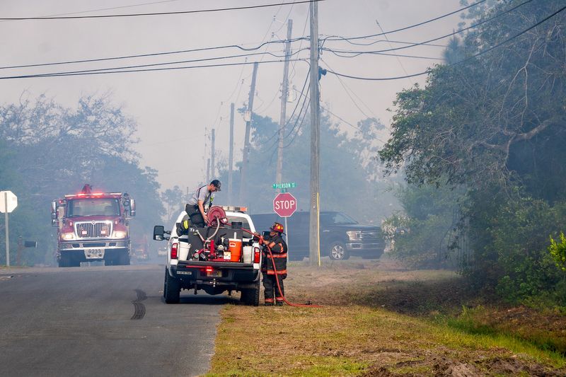
All burn bans in the Florida panhandle have been lifted, and the updated June 1 Significant Wildland Fire Potential Outlook no longer shows the area as having an above normal risk of wildfires.
While the Florida Forest Service marked fire potential in Bay County as high on June 5, the area only had a Keetch Byram Drought Index of 193, indicating that the recent rains have successfully saturated the soil. This number responds quickly to rain, although the low figure indicates that there’s less fuel for a fire to quickly spread.
NWS meteorologists forecast modest chances for rain starting on June 9, although they predict rainfall totals will be light.
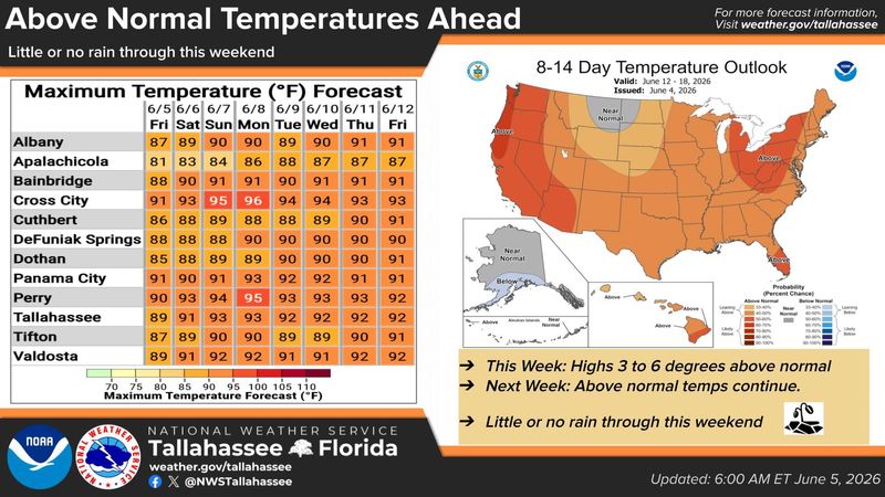
Meanwhile, the region is expected to heat up over the next week. In Panama City, NWS forecasters anticipate maximum temperatures in the low 90s, above normal for this time of year. A meteorologist in the area’s forecast discussion said some areas could see heat indices in the low 100s.
Summer is the panhandle’s rainy season, and a NWS meteorologist told the News Herald that they are hoping there will be enough rainfall to recharge surface and groundwater levels ahead of autumn, when the weather tends to dry out.
The Climate Prediction Center shows the best chances of this occurring over the next month, when above normal precipitation is expected. After June, precipitation has even chances of being above or below normal in our area.
Drought is expected to persist but improve over the course of the season, according to the CPC. Temperatures are expected to be above normal during that timeframe.
The NWS meteorologist said that if current summer weather patterns persist with normal rainfall, the area could get out of drought conditions.
Meanwhile, the National Oceanic and Atmospheric Administration is anticipating a below-normal Hurricane Season. NOAA said in a release that they’re expecting eight to 14 named storms and three to six hurricanes, including one to three major hurricanes.
This article originally appeared on The News Herald: Recent rain has relieved Bay County drought. But hot weather is ahead
Reporting by Dylan Gentile, Panama City News Herald / The News Herald
USA TODAY Network via Reuters Connect
By Dylan Gentile, Panama City News Herald | USA TODAY Network