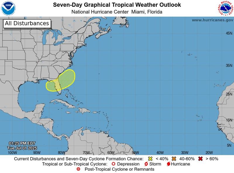
The National Hurricane Center continues to monitor a disturbance expected to stall off the southeast coast of the U.S. late this week, which could affect your Fourth of July weekend in Sarasota and Manatee County.
As of 2 p.m. on Jul. 1, chances for development over the next seven days are 30%.

Warm waters along the eastern Gulf and southern Atlantic coasts could provide the fuel necessary for development of a tropical depression or tropical storm around or just after July 4, AccuWeather said.
➤ Track all active storms
➤ Weather alerts via text: Sign up to get updates about current storms and weather events by location
Regardless of tropical cyclone development, showers and thunderstorms could spoil your holiday weekend at the beach.
The next named storm of the 2025 Atlantic hurricane season will be Chantal.
Is a tropical storm or hurricane coming toward Florida?
“Development may be a bit more likely on the Gulf side, as opposed to the Atlantic side of Florida, but at this point the entire zone is being watched,” DaSilva said, “At this time we feel the development window is from around July 4 to early next week.”
“A frontal boundary is expected to stall and weaken off the southeast U.S. coast late this week,” the National Hurricane Center said at 2 p.m. “An area of low pressure could develop from the weakening front by the weekend over the Atlantic waters off the southeast U.S., over Florida, or over the eastern Gulf.
“Some gradual tropical or subtropical development could occur thereafter as the low drifts and moves little.
“Regardless of development, heavy rainfall is possible across portions of the southeast U.S., particularly across the west-central Florida coast.”
“A cold front will dive off the coast late this week, and it may act as a catalyst for development either in the eastern Gulf or off the Southeast coast,” said Alex DaSilva, AccuWeather lead hurricane expert.
“Wind shear, which can inhibit development, is expected to be fairly low and ocean water temperatures in the Gulf are above average which can aid in development in the outlooked area.”
“Should clustering of thunderstorms and lowering pressure develop enough spin around a center with winds of 35-38 mph, a tropical depression may be born. Waters are warm enough (80 or higher) to allow and sustain tropical development,” according to AccuWeather.
Could tropical system impact Sarasota, Bradenton, Florida over July 4th holiday weekend?
“This system poses no direct threat to Florida over the next 5-7 days; however, this system could bring locally heavy rainfall, gusty winds and an increased rip current risk along the Gulf or Atlantic Coast later this week and will continue to be monitored closely,” the Florida Department of Emergency Management said.
“Those heading to the beaches for the holiday weekend from northern Florida and the Alabama and Mississippi panhandles to the Carolinas are urged to monitor the forecast, as there may be rough surf and rip currents and perhaps gusty winds should a tropical depression or storm develop,” DaSilva said.
Factors helping prevent tropical development include wind shear and dry air, including Saharan dust moving across the Atlantic and into the Gulf.
Sarasota, Manatee County 4th of July weekend weather forecast
The Fourth of July holiday weekend forecast for Sarasota and Manatee counties from the National Weather Service in Miami as of July 1, 2025:
Sarasota County
July 4: Showers likely and possibly a thunderstorm. Mostly sunny, with a high near 88. Light southwest wind increasing to 5 to 9 mph in the morning. Chance of precipitation is 70%. Friday night, scattered showers and thunderstorms. Mostly cloudy, with a low around 75. West wind around 5 mph becoming calm in the evening. Chance of precipitation is 30%.
July 5: Showers likely and possibly a thunderstorm. Partly sunny, with a high near 89. Light and variable wind becoming south southwest 5 to 7 mph in the morning. Chance of precipitation is 70%. Saturday night, scattered showers and thunderstorms. Mostly cloudy, with a low around 75. Chance of precipitation is 40%.
July 6: Showers and thunderstorms likely. Mostly sunny, with a high near 88. Chance of precipitation is 70%. Sunday night, showers and thunderstorms likely. Partly cloudy, with a low around 76. Chance of precipitation is 60%.
Manatee County
July 4: Day
Showers likely and possibly a thunderstorm. Partly sunny, with a high near 88. Southwest wind 5 to 9 mph. Chance of precipitation is 70%. Friday night, scattered showers and thunderstorms, mainly before 2 am. Mostly cloudy, with a low around 74. West southwest wind around 6 mph becoming light and variable in the evening. Chance of precipitation is 30%.
July 5: Scattered showers and thunderstorms, then showers and possibly a thunderstorm after 2 pm. High near 91. East wind 5 to 7 mph becoming south in the afternoon. Chance of precipitation is 80%. Saturday night, showers and possibly a thunderstorm before 8 pm, then scattered showers and thunderstorms after 8 pm. Low around 74. Chance of precipitation is 80%.
July 6: Showers and thunderstorms likely. Mostly sunny, with a high near 89. Chance of precipitation is 70%. Sunday night, showers and thunderstorms likely. Partly cloudy, with a low around 74. Chance of precipitation is 60%.
Sarasota, Manatee County, Florida live weather radar
Weather watches and warnings issued for Sarasota, Manatee County, Florida
When is the Atlantic hurricane season?
The Atlantic hurricane season runs from June 1 through Nov. 30.
Ninety-seven percent of tropical cyclone activity occurs during this time period, NOAA said.
The Atlantic basin includes the northern Atlantic Ocean, Caribbean Sea and Gulf of America, as the Gulf of Mexico is now known in the U.S. per an order from President Trump. NOAA and the National Hurricane Center are now using Gulf of America on its maps and in its advisories.
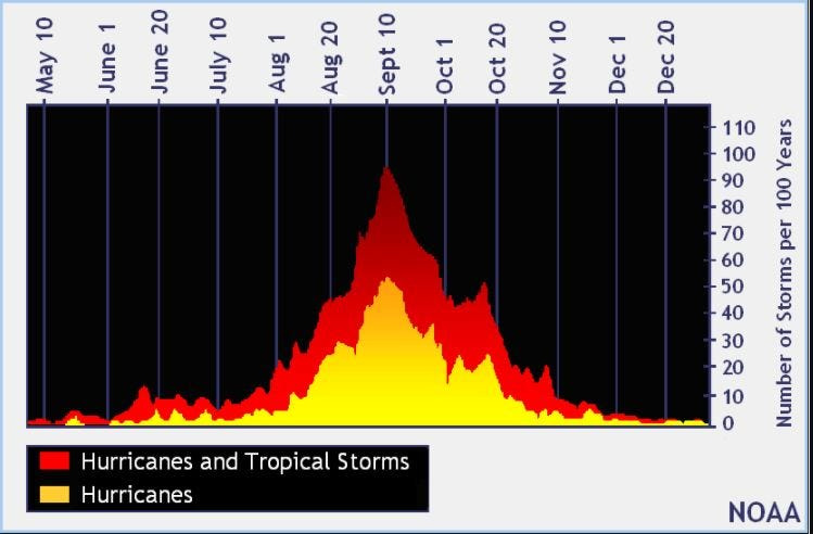
When is the peak of hurricane season?
The peak of the season is Sept. 10, with the most activity happening between mid-August and mid-October, according to the Hurricane Center.
National Hurricane Center map: See what forecasters watching now
Systems currently being monitored by the National Hurricane Center include:
Why does NHC say ‘tropical cyclone’ on its maps instead of hurricane or tropical storm?
Tropical cyclone is the generic term used by the National Weather Service, NOAA and the National Hurricane Center for any tropical system, even if it’s in the tropical Atlantic basin.
To be more precise, a tropical cyclone is a “rotating, organized system of clouds and thunderstorms that originates over tropical or subtropical waters and has closed, low-level circulation,” NOAA sadi.
Once maximum sustained winds reach 74 mph, what it is called is determined by where it originated:
Interactive map: Hurricanes, tropical storms that have passed near your city
Stay informed. Get weather alerts via text
Download your local site’s app to stay connected to the news. And look for our special subscription offers here.
This article originally appeared on Sarasota Herald-Tribune: NHC still watching system near Florida. Sarasota, Bradenton impact for July 4th weekend
Reporting by Kim Luciani and Cheryl McCloud, USA TODAY NETWORK – Florida / Sarasota Herald-Tribune
USA TODAY Network via Reuters Connect