Hurricanes Humberto and Imelda kept the National Hurricane Center busy as September ended. Although neither storm posed a direct threat to Florida or the United States, the two combined forces to bring dangerous surf and life-threatening beach conditions to the U.S.
Now we wait for the next named storm, and we may not have long to wait.

➤ Track all active storms
➤ Weather alerts via text: Sign up to get updates about current storms and weather events by location
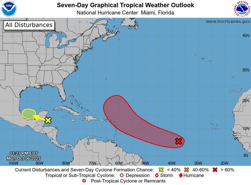
Invest 95L — AL95 — is a tropical wave moving quickly west across the Atlantic. It’s expected to strengthen into a tropical depression by the middle of the week as it approaches the Caribbean.
The next named storm of the season will be Jerry.
At 2 p.m., a trough of low pressure with a low chance for development is also highlighted on the National Hurricane Center’s tropical outlook page.
In the meantime, expect soggy conditions across most of Florida today, according to the National Weather Service.
Here’s the latest advisory from the National Hurricane Center as of 2 p.m. Monday, Oct. 6:
Storm tracker: Invest 95L moving toward Caribbean
Special note on the NHC cone: The forecast track shows the most likely path of the center of the storm. It does not illustrate the full width of the storm or its impacts, and the center of the storm is likely to travel outside the cone up to 33% of the time.
Spaghetti models for Invest 95L
Special note about spaghetti models: Illustrations include an array of forecast tools and models, and not all are created equal. The hurricane center uses only the top four or five highest performing models to help make its forecasts.
➤ Track Invest 95L
What is an invest?
Short for investigation, the National Hurricane Center uses the term invest for areas of low pressure it is monitoring for potential development into a tropical depression or storm.
Invests are not tropical depressions or tropical storms. They’re usually clusters of showers and thunderstorms, and just because they’ve been designated as an invest does not guarantee they’ll strengthen into a tropical storm or hurricane.
Invests run from 90 to 99, followed by a letter: L for the Atlantic basin and E for those in the eastern Pacific. After 99, it starts over again and the next invest would be 90.
Once something has been designated as an invest, specialized data sets and computer models can begin, including scheduling Hurricane Hunter aircraft missions and running spaghetti models.
When is Invest 95L likely to become a tropical depression?
Visible satellite images indicate the area of low pressure located over the tropical central Atlantic is gradually becoming better organized.
Environmental conditions appear generally conducive for slow development of this system, and a tropical depression is likely to form within the next couple of days while it moves quickly west-northwestward across the central tropicalAtlantic.
This system is expected to be near or north of the northern Leeward Islands on Thursday and Friday, and residents there should monitor its progress.
Will Invest 95L become Tropical Storm Jerry?
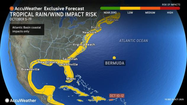
“Tropical storm number 10 of the Atlantic season appears to be mere days or hours away from forming, say AccuWeather hurricane experts, and it has a good chance of impacting land later this week,” according to AccuWeather.
“It is becoming likely that this will organize into a tropical storm this week,” said AccuWeather Senior Meteorologist Dan Pydynowski.
Where could budding Tropical Storm Jerry go?
Any tropical rainstorm or storm is still several days away from potentially impacting land as it moves to the west over the central Atlantic, AccuWeather forecasters said.
Caribbean residents especially are encouraged to keep an eye on the system as it moves west across the Atlantic.
“Steering winds may cause the storm to pass close to the northeastern Caribbean islands late this week or this upcoming weekend, bringing a glancing blow of rain and wind,” said Pydynowski.
Where it will go remains uncertain.
“While many options remain possible with its future track, the most likely track appears to turn the future storm to the north as it passes by the Caribbean islands,” said Pydynowski. “This would keep it east of the U.S. mainland.”
“Still, with that window of movement being well over a week out, interests all across the Caribbean and along the East Coast of the U.S. should closely monitor the tropics through the middle of the month,” AccuWeather said.
What other tropical waves, disturbances are in Atlantic basin now?
Northwestern Caribbean, Southwestern Gulf: A trough of low pressure located over the northwestern Caribbean Sea is producing a large area of disorganized showers and thunderstorms.
This system is expected to move across the Yucatan Peninsula tonight and early Tuesday, and then track over the Bay of Campeche late Tuesday through Wednesday.
Some slow development of this system is possible over the Bay of Campeche around the middle of the week. Regardless of development, areas of heavy rain and gusty winds are likely across portions of the Yucatan Peninsula, Belize, and southern Mexico during the next few days.
Along with Invest 95L, the National Hurricane Center also is tracking two other tropical waves in the Atlantic basin:
What do the colored, hatched areas on the NOAA map mean?
The hatched areas on the National Hurricane Center’s tropical outlook map indicate “areas where a tropical cyclone — which could be a tropical depression, tropical storm or hurricane — could develop,” said National Hurricane Center Deputy Director Jamie Rhome.
The colors make it visibly clear how likely a system could develop, with yellow being low, orange medium, and red high.
The National Hurricane Center generally doesn’t issue tropical advisories until there is a named storm, but there is an exception.
“If a system is near land and there is potential for development, the National Hurricane Center won’t wait before it issues advisories, even if the system hasn’t become an actual storm. This gives residents time to prepare,” Rhome said.
Who is likely to be impacted by Invest 95L, tropical waves out there?
It’s too early at this time to determine if there will be any impact to Florida or the U.S. from Invest 95L or the other tropical waves out there.
➤ Excessive rainfall forecast
Forecasters urge all residents to keep an eye on the tropics and to always be prepared.
Florida weather radar for Oct. 6, 2025
Florida weather forecast for Oct. 6, 2025
Florida weather forecast for Oct. 6, 2025
Weather watches and warnings issued in Florida
When is the Atlantic hurricane season?
The Atlantic hurricane season runs from June 1 through Nov. 30.
Ninety-seven percent of tropical cyclone activity occurs during this time period, NOAA said.
The Atlantic basin includes the northern Atlantic Ocean, Caribbean Sea and Gulf of America, as the Gulf of Mexico is now known in the U.S. per an order from President Trump. NOAA and the National Hurricane Center are now using Gulf of America on its maps and in its advisories.
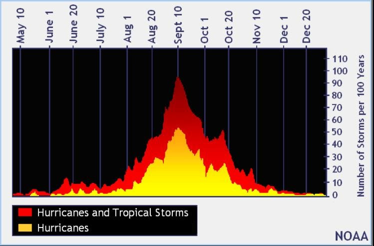
When is the peak of hurricane season?
The peak of the season is Sept. 10, with the most activity happening between mid-August and mid-October, according to the Hurricane Center.
Hurricane names for 2025 season
Here are the names for the 2025 Atlantic hurricane season, along with how to pronounce them. The first hurricane of the season typically forms Aug. 11.
National Hurricane Center map: See what forecasters are watching now
Systems currently being monitored by the National Hurricane Center include:
Why does NHC say ‘tropical cyclone’ on its maps instead of hurricane or tropical storm?
Tropical cyclone is the generic term used by the National Weather Service, NOAA and the National Hurricane Center for any tropical system, even if it’s in the tropical Atlantic basin.
To be more precise, a tropical cyclone is a “rotating, organized system of clouds and thunderstorms that originates over tropical or subtropical waters and has closed, low-level circulation,” NOAA sadi.
Once maximum sustained winds reach 74 mph, what it is called is determined by where it originated:
Interactive map: Hurricanes, tropical storms that have passed near your city
Stay informed. Get weather alerts via text
What’s next?
We will update our tropical weather coverage daily.
Download your local site’s app to ensure you’re always connected to the news. And look for our special subscription offers here.
This story has been updated to include new information.
This article originally appeared on Sarasota Herald-Tribune: National Hurricane Center tracking Invest 95L. Will it become Tropical Storm Jerry?
Reporting by Cheryl McCloud, USA TODAY NETWORK – Florida / Sarasota Herald-Tribune
USA TODAY Network via Reuters Connect