
The worst drought on record in Leon County officially improved after a weeks-long rainy spell that included the remnants of Tropical Storm Arthur.
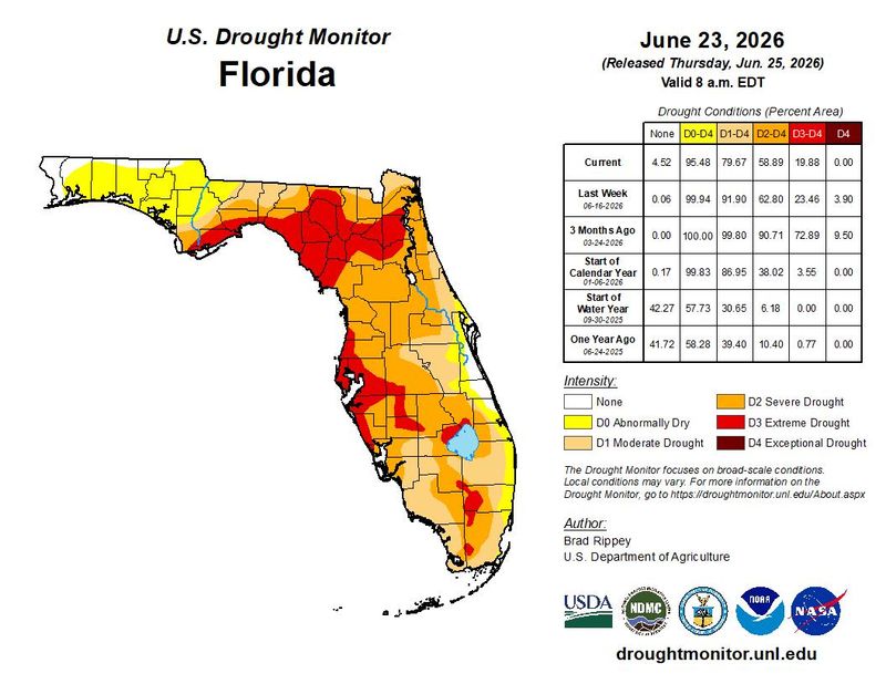
The U.S. Drought Monitor’s latest weekly map, released June 25, shows most of the county improved from a severe drought (D2) to a moderate drought (D1).

A portion in the south county improved from extreme drought (D3) to severe drought.
The whole county had been in exceptional drought (D4) – the most intense level – as recently as the week of May 19, according to Wright Dobbs, meteorologist with the National Weather Service in Tallahassee.
“We’re going in the right direction, that’s for sure,” he said. “Overall, the rainfall has been promising, and most areas have been definitely glad to see it. And it has led to some improvements in the drought.”
Over the past 30 days, Tallahassee International Airport, the official measuring spot, saw just over 6 inches of rain, roughly 87% of normal, according to the NWS Tallahassee drought information statement issued June 25.
But Dobbs said other parts of the county, including the northeast and east, have seen above normal amounts with higher thunderstorm activity.
The city had been in its worst drought ever, with only 22 inches of rain falling between early July 2025 and early April 2026, according to the Weather Service. That was around half or less the normal amount.
The area started seeing improvement in mid-May, Dobbs said, with parts of the Florida Panhandle and southeast Alabama seeing heavier rain and moving out of drought territory.
“The rainfall amounts have been a little bit less and more scattered across the Florida Big Bend, so that’s where we see drought still lingering,” he added.
Contact Jeff Burlew at jburlew@tallahassee.com or 850-599-2180.
This article originally appeared on Tallahassee Democrat: Leon County drought eases after recent heavy rains
Reporting by Jeff Burlew, Tallahassee Democrat / Tallahassee Democrat
USA TODAY Network via Reuters Connect
By Jeff Burlew, Tallahassee Democrat | USA TODAY Network