The National Hurricane Center said a tropical depression could form in the Gulf this week after a system of low pressure moves across Florida from the Atlantic.
Forecasters have been watching the system — now designated as Invest 93L — for several days. Overnight chances for development continued to tick up and now stand at 40% over the next 48 hours.

So what does this mean for Jacksonville? According to the National Weather Service, there’s an increased risk of locally heavy rain and isolated flooding across Florida through Thursday, even if no tropical system develops.
Additionally, heavy rainfall is expected to shift into the north-central Gulf Coast later in the week.
➤ Track all active storms
What is the weather in Jacksonville today?
The National Weather Service is calling for a 40% chance of showers and thunderstorms this afternoon, mainly after noon. That means while much of the day could stay dry, scattered storms are likely to pop up, especially in the later hours.
Today’s temperatures are expected to climb to around 89 degrees, but the humidity will make it feel hotter — with a heat index possibly reaching 101.
Additionally, winds from the northeast will be breezy, around 11 to 15 mph, with gusts up to 20 mph, which could help ease the heat a bit but might also bring quick-moving clouds and sudden showers.
Tonight, the chance of rain is expected to drop to 20 percent before 11 p.m, with mostly cloudy skies and an overnight low around 75, and lighter southeast winds.
How will the Invest 93L storm impact Jacksonville?
Even if the system doesn’t strengthen into a tropical depression or storm, the National Weather Service and National Hurricane Center warn that increased potential for locally heavy rainfall — especially along the I-75 corridor — could bring localized flash flooding to portions of Florida, including Jacksonville, through mid-week.
➤ Weather alerts via text: Sign up to get updates about current storms and weather events by location
NWS Jacksonville weather radar shows path of storms associated with Invest 93L
What will be the name of the next hurricane?
The next named storm of the 2025 Atlantic hurricane season will be Dexter.
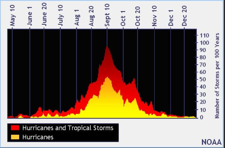
Historically, the fourth named storm of the Atlantic hurricane season arrives Aug. 15. The last two named storms of the season — Barry and Chantal — developed earlier than normal.
Here’s the latest advisory from the National Hurricane Center as of 8 a.m. July 15:
Invest 93L expected to move across Florida today, July 15
Satellite and radar data indicate the shower and thunderstorm activity associated with the low pressure located just offshore of the east coast of Florida remains disorganized.
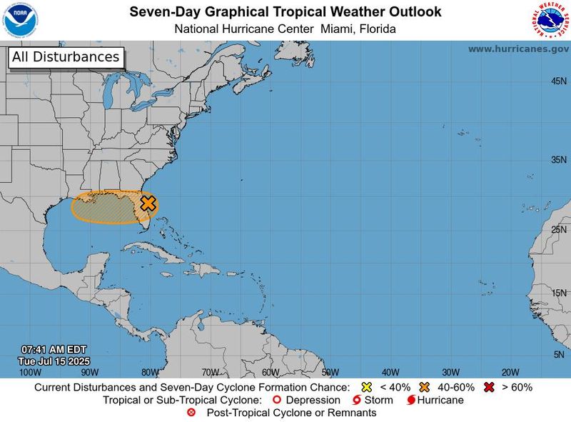
This system is forecast to move westward across the Florida Peninsula today and then reach the northeastern Gulf by Wednesday, July 16.
Environmental conditions appear generally favorable for additional development, and a tropical depression could form while the system moves across the northeastern and north-central Gulf.Regardless of development, heavy rainfall could produce localized flash flooding over portions of Florida through mid-week.
Heavy rainfall could also cause flash flooding for portions of the north-central Gulf Coast during the middle to latter portions of this week.
Spaghetti models for Invest 93L
Special note about spaghetti models: Illustrations include an array of forecast tools and models, and not all are created equal. The hurricane center uses only the top four or five highest performing models to help make its forecasts.
What is an invest?
Short for investigation, the National Hurricane Center uses the term invest for areas of low pressure it is monitoring for potential development into a tropical depression or storm.
Invests are not tropical depressions or tropical storms. They’re usually clusters of showers and thunderstorms, and just because they’ve been designated as an invest does not guarantee they’ll strengthen into a tropical storm or hurricane.
Invests run from 90 to 99, followed by a letter: L for the Atlantic basin and E for those in the eastern Pacific. After 99, it starts over again and the next invest would be 90.
Once something has been designated as an invest, specialized data sets and computer models can begin, including scheduling Hurricane Hunter aircraft missions and running spaghetti models.
What impacts are expected in Florida from Invest 93L?
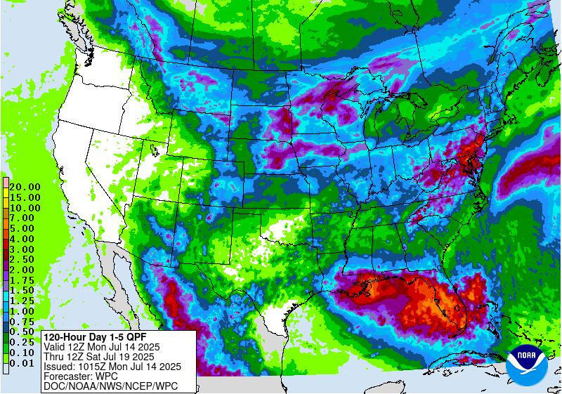
Get ready for some heavy rain and localized flash flooding over portions of Florida through mid-week, even if a tropical system doesn’t develop, according to the National Hurricane Center.
“Heavy downpours are expected to continue across much of the Florida Peninsula through Tuesday night. Thunderstorms, infused with tropical moisture, could produce more than 4 inches of rain,” said AccuWeather Hurricane Expert Alex DaSilva.
Those at the Florida beaches will also experience rough surf and strong rip currents into Wednesday.
➤ How to set up emergency cellphone notifications for flash flood warnings and safety tips
➤ Excessive rainfall forecast
“A more organized tropical system would bring a larger swath of heavy rain and a more widespread flooding risk,” DaSilva added.
AccuWeather forecasters Tuesday, July 15, were predicting a tropical depression will make landfall in southeastern Louisiana Thursday morning, July 17.
“The farther south that the tropical rainstorm is able to travel over Florida, the longer it will have over the Gulf to strengthen before landfall,” DaSilva said. It’s not out the question that, in this scenario, the tropical system would have enough time to become a tropical storm.
Florida weather radar for July 15, 2025
National Weather Service Florida forecast as Invest 93L moves across state
National Weather Service offices around Florida warned on X it was still too early to determine specifics about the track, strength or impacts from Invest 93L and advised residents to monitor forecasts for the latest updates.
2025 hurricane season so far
An average Atlantic hurricane season has 14 named storms, seven hurricanes, and three major hurricanes.
Here’s when this year’s named storms have developed, compared to historical averages:
Weather watches and warnings issued in Florida
Hurricane names for 2025 season
Here are the names for the 2025 Atlantic hurricane season, along with how to pronounce them:
When is the Atlantic hurricane season?
The Atlantic hurricane season runs from June 1 through Nov. 30.
Ninety-seven percent of tropical cyclone activity occurs during this time period, NOAA said.
The Atlantic basin includes the northern Atlantic Ocean, Caribbean Sea and Gulf of America, as the Gulf of Mexico is now known in the U.S. per an order from President Trump. NOAA and the National Hurricane Center are now using Gulf of America on its maps and in its advisories.
When is the peak of hurricane season?
National Hurricane Center map: See what forecasters watching now
Systems currently being monitored by the National Hurricane Center include:
Why does NHC say ‘tropical cyclone’ on its maps instead of hurricane or tropical storm?
Tropical cyclone is the generic term used by the National Weather Service, NOAA and the National Hurricane Center for any tropical system, even if it’s in the tropical Atlantic basin.
To be more precise, a tropical cyclone is a “rotating, organized system of clouds and thunderstorms that originates over tropical or subtropical waters and has closed, low-level circulation,” NOAA sadi.
Once maximum sustained winds reach 74 mph, what it is called is determined by where it originated:
Interactive map: Hurricanes, tropical storms that have passed near your city
Stay informed. Get weather alerts via text
What’s next?
We will update our tropical weather coverage daily.
Download your local site’s app to ensure you’re always connected to the news. And look for our special subscription offers here.
(This story has been updated to include new information.)
This article originally appeared on Florida Times-Union: Hurricane center tracking Invest 93L. Will it impact Jacksonville?
Reporting by Doris Alvarez Cea, Jacksonville Florida Times-Union / Florida Times-Union
USA TODAY Network via Reuters Connect