Chances of formation for a tropical wave over the Atlantic, formerly Invest 91L, dissipated on Sept. 6, according to the National Hurricane Center.
The hurricane center is now tracking two tropical waves over the central Atlantic and western Caribbean.

No tropical cyclone formation is expected during the next seven days, according to the latest NHC advisory.
2025 Hurricane Season Guide: Storm preparedness tips, supply list, evacuation zones
➤ Track all active storms
➤ Weather alerts via text: Sign up to get updates about current storms and weather events by location
However, with water temperatures in the Gulf running above the historical average, “any cluster of showers and thunderstorms that organize in the Gulf and along the southern Atlantic coast could evolve into a tropical storm, especially from mid- to late September,” the peak of hurricane season, AccuWeather forecasters warned.
Forecasters urge residents to keep an eye on the tropics and always be prepared.
The next named storm of the 2025 Atlantic hurricane season will be Gabrielle.
➤ What does history tell us about Florida and September hurricanes? Will you be surprised?
Here’s the latest advisory from the National Hurricane Center as of 8 a.m. Sunday, Sept. 7.
National Hurricane Center tracking 2 tropical waves
Tropical wave 1: A central Atlantic tropical wave is near 44W from 17N southward, and moving west at 10 to 15 kt. Scattered moderate convection is noted from 11N to 15N between 39W and 46W.
Tropical wave 2: A western Caribbean tropical wave is near 78W from eastern Cuba to around 10N, moving W at 15 to 20 kt. Scattered moderate convection is noted from Jamaica southward into Colombia, from about 75W to 81W.
Colorado State University predicting tropics to become more active
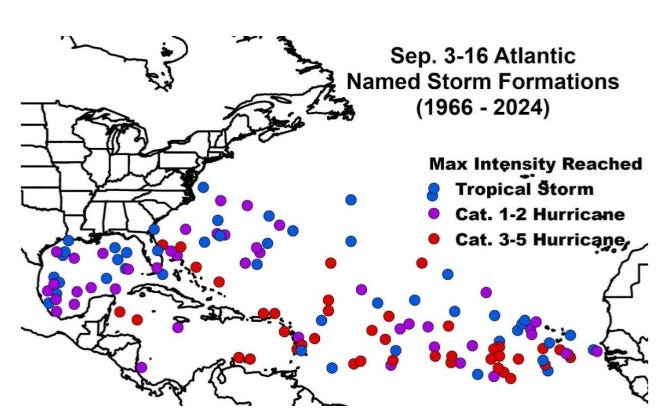
In its two-week forecast for Sept. 3-16, Colorado State University forecasters are predicting activity will pick up over the next couple of weeks.
“Global model ensembles are pretty aggressive with additional tropical cyclone development in days 8 through 14, with potential formations in the eastern Atlantic as well as in the western Caribbean/southern Gulf,” the CSU forecast said.
“The primary threat formation area for major hurricanes in early- to mid-September is in the eastern and central tropical Atlantic.”
What should be in a hurricane kit? Buy needed supplies tax free
Officials regularly encourage Florida residents to prepare for storms before a hurricane is approaching, while shelves are fully stocked and you aren’t battling crowds all rushing to the store at the same time.
“It only takes one storm to make it an impactful year for your community,” the National Hurricane Center Miami posted on X. “Hurricane season is a marathon, not a sprint.”
➤ See list of emergency supplies you can now buy tax free
On Aug. 1, specific hurricane supplies became permanently tax-free in Florida, ranging from batteries to generators.
➤ Don’t have a hurricane supply kit? From the basics to the extras, here’s what you need
Here are some of the basics you should have:
Florida live weather radar for Sept. 7, 2025
Florida weather watches and warnings
When is the Atlantic hurricane season?
The Atlantic hurricane season runs from June 1 through Nov. 30.
Ninety-seven percent of tropical cyclone activity occurs during this time period, NOAA said.
The Atlantic basin includes the northern Atlantic Ocean, Caribbean Sea and Gulf of America, as the Gulf of Mexico is now known in the U.S. per an order from President Trump. NOAA and the National Hurricane Center are now using Gulf of America on its maps and in its advisories.
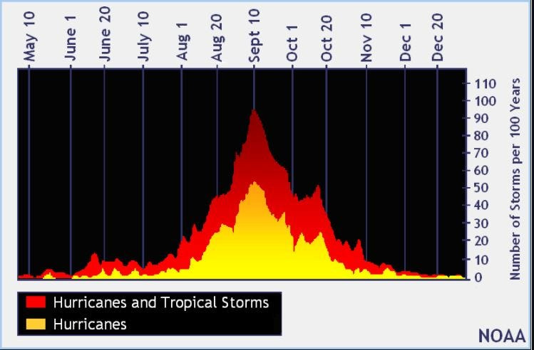
When is the peak of hurricane season?
The peak of the season is Sept. 10, with the most activity happening between mid-August and mid-October, according to the Hurricane Center.
Hurricane names for 2025 season
Here are the names for the 2025 Atlantic hurricane season, along with how to pronounce them. The first hurricane of the season typically forms Aug. 11.
National Hurricane Center map: See what forecasters watching now
Systems currently being monitored by the National Hurricane Center include:
Why does NHC say ‘tropical cyclone’ on its maps instead of hurricane or tropical storm?
Tropical cyclone is the generic term used by the National Weather Service, NOAA and the National Hurricane Center for any tropical system, even if it’s in the tropical Atlantic basin.
To be more precise, a tropical cyclone is a “rotating, organized system of clouds and thunderstorms that originates over tropical or subtropical waters and has closed, low-level circulation,” NOAA sadi.
Once maximum sustained winds reach 74 mph, what it is called is determined by where it originated:
Interactive map: Hurricanes, tropical storms that have passed near your city
Stay informed. Get weather alerts via text
What’s next?
We will update our tropical weather coverage daily.
Download your local site’s app to ensure you’re always connected to the news. And look for our special subscription offers here.
This story has been updated to include new information.
This article originally appeared on Palm Beach Post: Florida weather: NHC tracking tropical waves after Invest 91L development dissipates
Reporting by Cheryl McCloud and Kim Luciani, USA TODAY NETWORK – Florida / Palm Beach Post
USA TODAY Network via Reuters Connect