There’s some bad news when it comes to Florida weather over the three-day holiday weekend.
And then there’s some uncertainty.

➤ Track all active storms
➤ Weather alerts via text: Sign up to get updates about current storms and weather events by location
A “wet and active weather pattern” is forecast to continue for the Fourth of July and into the holiday weekend, according to the Florida Department of Emergency Management.
What remains uncertain is exactly where a system of low pressure will develop, which currently has a 40% chance of evolving into something tropical or subtropical over or near Florida.
If the right conditions are there, they could “potentially ignite tropical development,” said Alex DaSilva, AccuWeather lead hurricane expert in an email Monday, June 30.
“This is fairly common this time of the year, June and July, that you get old frontal boundaries kind of coming off the southeast coast and into the Gulf and stalling. And then you get a little area of spin to develop along that decaying cold front, and then that’s how you get these usually fairly short-lived tropical systems early in the season.
“They tend to be a little on the weaker side, but they can bring a lot of rain, especially if they do develop. I think that’s what we might end up seeing here.”
National Hurricane Center tracking area of disturbance
An area of low pressure could develop near the southeast U.S. Atlantic or Gulf coasts by this weekend along a weakening frontal boundary, the National Hurricane Center said at 8 a.m. July 2.
“Environmental conditions appear only marginally conducive for some slow development, but a tropical or subtropical depression could form in this region over the weekend or early next week while the system moves little.
“Regardless of development, heavy rainfall is possible across portions of the southeast U.S., particularly across the west-central Florida coast, the National Hurricane Center said.
➤ Chances increase slightly for tropical development over Fourth of July. See Florida impact
Will tropical storm impact Florida over Fourth of July weekend? Here’s what could happen
“Regardless of tropical development, local flooding rain risk remains into the weekend. Daily afternoon and evening thunderstorms are expected. … with a potential for flash flooding, the National Weather Service Jacksonville posted on X.
“Models disagree on this exact point about where tropical development could occur,” according to the Florida Public Radio Emergency Network.
“These two models represent two very different scenarios; they could produce opposite results regarding the weather for the holiday weekend in Florida,” Florida Public Radio Emergency Network said.
“If the American model verifies and a storm develops over the Gulf, there could be increased rainfall activity for the Florida peninsula during the holiday weekend. If the European model is confirmed, conditions are likely to remain drier than normal for the July 4th weekend.”
“If tropical system does eventually develop east of Florida or south of the Carolinas, steering currents are light, so it could well linger near the Gulf Stream into next week,” said Dr. Ryan Truchelut, chief meteorologist with WeatherTiger. “Dry air and some northerly wind shear would most likely keep anything that develops weak.”
Truchelut is a Florida meteorologist who works with the USA TODAY Network.
“For Florida’s sake, it would be better for it to happen east of Florida because then it would likely just get pushed out to sea.”
Will it rain in Florida over Fourth of July holiday weekend?
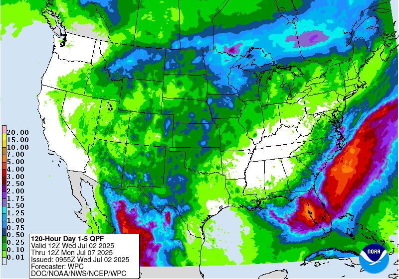
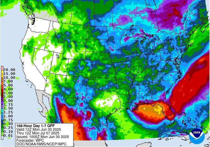
Even if there is no tropical development, expect plenty of rain this week and into the holiday weekend across Florida, DaSilva said.
The National Weather Service predicted up to six inches of rain for portions of Florida through the weekend, with higher localized amounts possible.
“While the computer models have done a fair job of indicating that the low pressure will be weak and very disorganized, due to weak steering winds and drier air, they are struggling to define where this low could develop,” the Florida Department of Emergency Management said.
“If this low was to develop more towards the west (over the eastern Gulf waters), there would be a greater chance for more widespread rainfall along the Panhandle and West Coast.
“If the low was to develop more towards the east (over the Atlantic waters), some drier air would be able to filter into the western side along the Panhandle.”
Here’s the forecast around Florida for the holiday weekend:
Heading to one of the central Florida theme parks? Here’s your forecast for Orlando:
Will Tropical Storm Chantal form ahead of historical average?
The average date for the third named storm in the Atlantic basin is Aug. 3, DaSilva said.
Andrea, the first named storm of the season formed a little later than average, on June 24, four days past the average date of June 20 for the first named storm of the season.
Barry formed June 29, well ahead of the historical average of July 17.
Water temperatures in the Gulf would support tropical development, but wind shear and some dry air from Saharan dust would work against tropical development, DaSilva said.
“We don’t anticipate this blowing up into a hurricane. If it develops, it’s likely to be a tropical depression or a tropical storm, which could enhance the rainfall across Florida.”
Storms developing close to US tend to be rainmakers with little time to react
“Most of the time, ‘homegrown’ storms tend to be on the weaker side in terms of wind speed, but a lot of times they tend to be big rainmakers,” DaSilva said.
“They also give people less time to react because they form closer to the coast. You don’t have the luxury of watching it come across the entirety of the Atlantic. We’re urging people to follow the forecast updates closely over the next couple of days.
“It’s possible that nothing develops at all and it just happens to be a wetter weekend. But there is also the possibility that we might end up with a tropical depression or a tropical storm, and it can really enhance the rainfall, and we could have some flooding issues.
“There isn’t enough time. If anything develops, it would only be over the water for a day or two before pushing inland if it develops in the eastern Gulf.”
Weather alerts issued in Florida
NWS radar: Track storms moving across Florida
See latest around Florida: Follow National Weather Service offices on X
Stay informed. Get weather alerts via text
What’s next?
We will continue to update our weather coverage as conditions warrant. Download your local site’s app to ensure you’re always connected to the news. And look for our special subscription offers here.
This article originally appeared on Naples Daily News: Florida forecast still looks wet for holiday weekend. What about the tropical disturbance?
Reporting by Cheryl McCloud, USA TODAY NETWORK – Florida / Naples Daily News
USA TODAY Network via Reuters Connect