
What do you get when you combine Florida’s typical summer heat and humidity with a heat dome?
The answer: Even more heat and humidity.

And it’s already started.
Florida will be under a heat dome this week — along with a huge chunk of the United States.
Expect temperatures up to 6 degrees above the historical average in some areas across Florida through the week, said Alex DaSilva, AccuWeather meteorologist, via email.
Shop Amazon for America250
➤ Weather alerts via text: Sign up to get updates about current storms and weather events by location
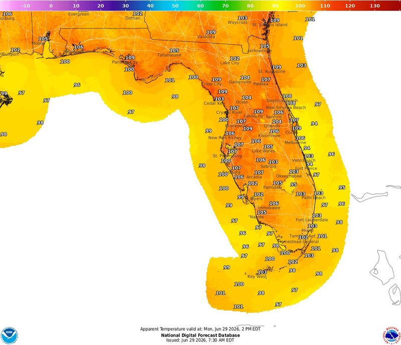
Feels-like temps could reach as high as 112, the National Weather Service Tallahassee warned for residents June 29.
Here’s what to expect in the week leading up to the Fourth of July and how to stay safe from the heat if you’ll be celebrating America’s 250th birthday outside.
How hot will Florida get this week? Up to 6 degrees above average
Florida will be under the heat dome this week, with temperatures expected to be above average in most areas, DaSilva said.
“The areas with the hottest temperatures will be across the Panhandle, where high temperatures will be 3 to 6 degrees above historical average through the week.
➤ What is a heat dome and why is it so dangerous?
“Across southern Florida, high temperatures will be 2 to 4 degrees above historical averages.
“Overall, AccuWeather RealFeel Temperatures will be between 100 to 110 degrees this week across the state, with the highest values in the Panhandle.
“There can also be periodic thunderstorms throughout the week that can offer some relief from the heat but can bring heavy downpours and localized damaging winds.
“Temperatures are expected to slightly drop on Saturday (July 4) and Sunday, but will still be near or slightly above historical averages.”
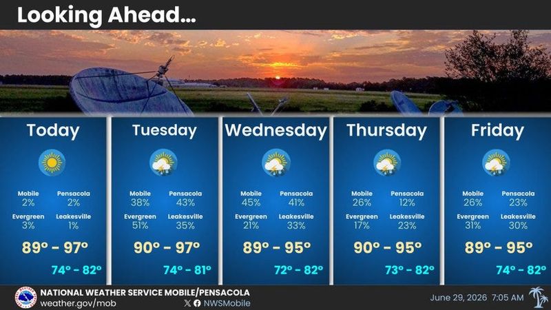
Pensacola, Florida forecast: Heat index 103-107 most of week
Summertime heat continues through this week with heat indices as high as 103 to 107 any given day. Heat indices may approach around 108 June 30 for most locations, according to the National Weather Service Mobile.
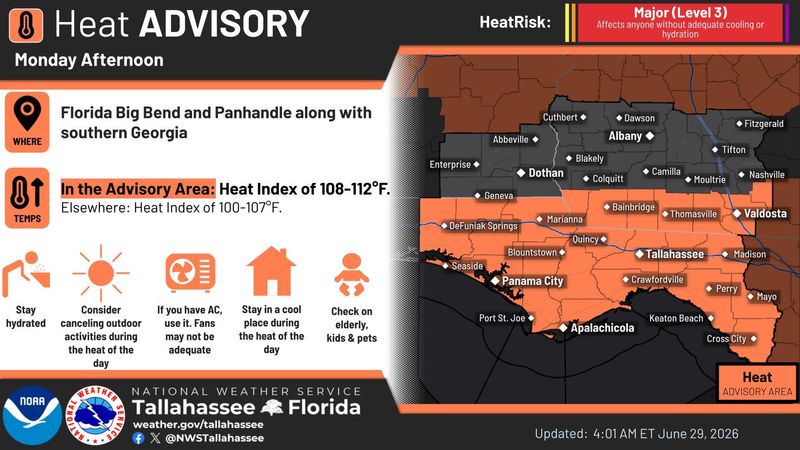
Tallahassee, Florida forecast: Dangerous heat expected
Dangerous heat is expected June 29-June 30. Afternoon thunderstorms are forecast to return June 29 and especially June 30; some may produce strong wind gusts and frequent lightning, according to the National Weather Service Tallahassee.
By the Independence Day weekend, humidity will increase. This means both a return to dangerous heat indices and also increasing chances for showers and storms.
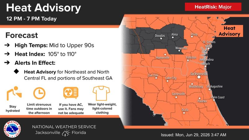
Jacksonville, Florida forecast: Rain chances increase for holiday weekend
The heat index could reach 105 to 110 degrees June 29, and could reach as high as 112 across parts of Northeast Florida by July 3, according to the National Weather Service Jacksonville.
Rain chances are expected to increase across all areas over the Fourth of July weekend.
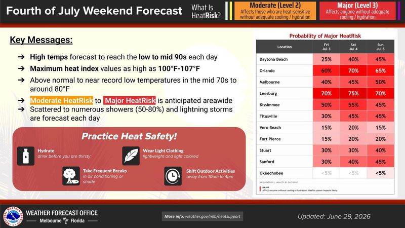
East-Central Florida forecast: Above-normal temps could impact your Fourth of July plans
Hot and muggy conditions continue the rest of the week and into the holiday weekend, with peak heat indices 100-107 each afternoon, according to the National Weather Service Melbourne.
Scattered to numerous showers (50-80%) and lightning storms are forecast each day.
Daytona Beach
Melbourne
Port St. Lucie
Orlando
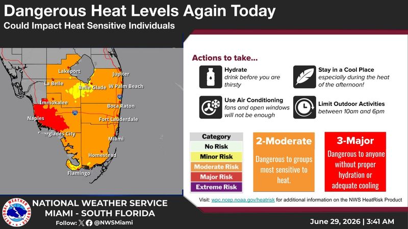
South Florida forecast: Dangerous temps, heat index up to 110
Dangerous temperatures again June 29, with highs hitting mid-upper 90s in many locations of South Florida, along with max heat index values possibly reaching the 105-110 degrees range at times, especially interior/western Collier County, according to the National Weather Service Miami.
Max temps could reach the mid-upper 90s mid week, and stay in the low-mid 90s through July 5.
Late afternoon and early evening thunderstorms possible through the weekend, especially over interior areas.
West Palm Beach
Miami
Naples
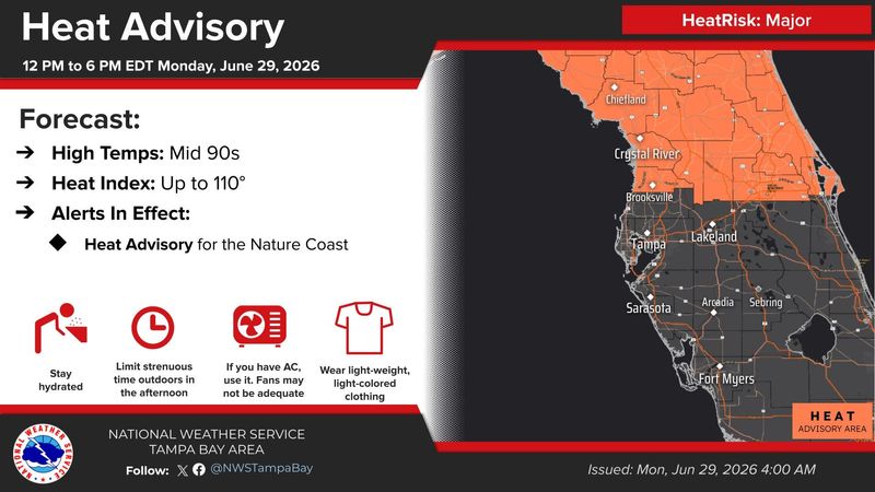
Southwest Florida forecast: Dangerous heat, above-normal temps expected
Dangerous heat today with highs in the mid 90s and feels like temps up to 110 degrees across the Nature Coast, according to the National Weather Service Tampa Bay. Heat index of 100 to 107 expected through the week.
Temperatures will remain slightly above normal with daytime highs from the upper 80s along the coast to the mid 90s inland and overnight lows in the mid 70s to around 80 degrees.
Scattered to numerous showers and thunderstorms are expected each day, mainly during the afternoon and evening hours.
Fort Myers
Sarasota
Tampa
Heat advisories issued for huge portion of Florida
Stay informed. Get weather alerts via text
What’s next?
We will continue to update our weather coverage as conditions warrant. Download your local site’s app to ensure you’re always connected to the news. And look for our special subscription offers here.
Cheryl McCloud is a journalist for the USA TODAY Network-Florida’s service journalism Connect team. You can get all of Florida’s best content directly in your inbox each weekday day by signing up for the free newsletter, Florida TODAY, at https://jacksonville.com/newsletters.
This article originally appeared on Florida Times-Union: Florida braces for ‘dangerous’ heat ahead of Fourth of July
Reporting by Cheryl McCloud, USA TODAY NETWORK – Florida / Florida Times-Union
USA TODAY Network via Reuters Connect
By Cheryl McCloud, USA TODAY NETWORK – Florida | USA TODAY Network