What was that?
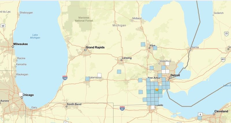
That was the collective reaction in Monroe County at 5:32 p.m. Monday, May 4, as the area was rattled by an earthquake that according to U.S. Geological Survey measured a Magnitude 2.7 on the Richter Scale. People reported feeling the quake about 50 miles from its epicenter near Carleton, into northern Ohio.

“Heard a boom and house shook in Sumpter Township (about 12 miles north of Carleton). Thought someone hit my house,” posted Sandy Marsh on Facebook.
David Baldwin-Terrasi posted that he felt the quake just east of Custer Airport in Frenchtown Township. “I was in the kitchen and there was a boom and the stove rattled,” he said.
It’s the second earthquake in the western Lake Erie basin in less than two weeks, following a Magnitude 2.9 quake on April 26 about 4.3 miles south-southeast of Amherstburg, Ontario, Canada, near where the Detroit River meets Lake Erie.
But earthquakes in this region remain infrequent, relatively mild events, according to Yihe Huang, an associate professor and earthquake researcher with the University of Michigan.
A Magnitude 4.2 quake hit in central Lake Erie on July 17, 2021. A Magnitude 4.0 temblor hit on the southern shore of Lake Erie northeast of Cleveland on June 19, 2019. But in Southeast Michigan, the quakes in recent history have remained in the under Magnitude 3.0 range.
“We do have these kind of earthquakes in the region, but they are not occurring every year,” Huang said. “Every few years, we observe a few of these earthquakes.”
A seismically active location like Southern California feels more intense earthquakes more frequently because it’s where two major tectonic plates, the North American Plate and Pacific Plate, grind together and build up energy that sometimes slips and forms an earthquake.
“We don’t really have major plate boundaries close to Michigan; it’s a more quiet space of tectonic motion,” Huang said. “But we do have some small faults here and there. They can still have some smaller earthquakes, and sometimes they can be clustered like this.”
The largest earthquake ever recorded in Michigan was a Magitude 4.6 near the town of Coldwater in central southern Michigan on Aug. 10, 1947. A magnitude 5.0 earthquake struck 25 miles east of Cleveland on Jan. 31, 1986 − a quake felt as far away as Washington, D.C. But that area south of Michigan has larger fault lines that can build up more energy for more powerful earthquakes, Huang said.
“So far we don’t really see the large fault structure here, close to the western part of Lake Erie,” she said. “But this could really be limited by the data we have, because we don’t really have that much long history of recorded earthquakes, and we really didn’t have that many seismometers here recording earthquakes in the past, either.”
Contact Keith Matheny: kmatheny@freepress.com.
This article originally appeared on Detroit Free Press: Why recent Lake Erie earthquakes don’t signal major risk for Michigan
Reporting by Keith Matheny, Detroit Free Press / Detroit Free Press
USA TODAY Network via Reuters Connect