Threats to Michigan dams, roads and bridges continue Friday, April 17 as northern Michigan and parts mid-Michigan remain under a flood warning through the weekend with more rain in the forecast.
The Cheboygan Dam water level continued to rise Thursday and the next several days will be precarious for the state’s stressed infrastructure.

Areas west of Interstate 75 in northern Michigan could see an additional 0.25 to 0.75 inches of rain through Saturday night, according to the National Weather Service.
Here’s the latest on Michigan’s dams and flooding.
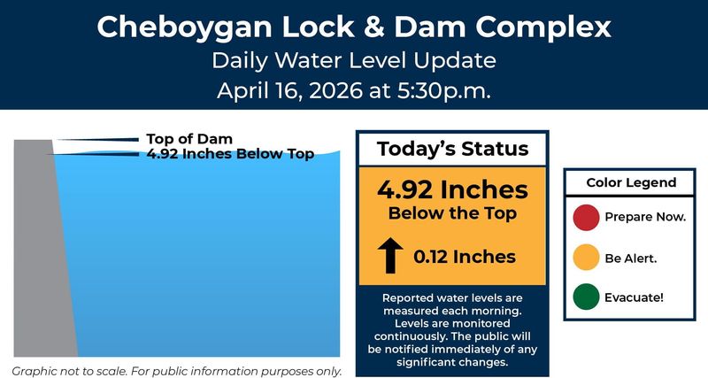
Cheboygan Dam rises again Thursday evening
The water level at the Cheboygan Lock and Dam Complex reached 4.92 inches from the top as of 5:30 p.m. Thursday, April 16. A update on the level was expected Friday morning.
Current Michigan warnings, advisories
To view warning details, click on a shaded region on the map — zoom in if needed. The dark green shading indicates a flood watch. The neon green shading indicates either a flood warning or a flood advisory.
Additional details from the National Weather Service on the flood watches and the flood warnings are also available online.
Live Michigan weather radar
What is the ‘ready, set, go’ plan?
Officials are promoting the “ready, set, go” safety approach when it comes to flood emergencies. It includes these steps:
—Jalen Williams
This article originally appeared on Detroit Free Press: Michigan dams, bridges face more rain in forecast: Flood updates
Reporting by Tanya Wildt, Detroit Free Press / Detroit Free Press
USA TODAY Network via Reuters Connect