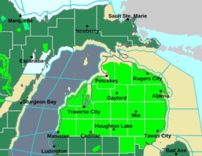
The entire northern half of Lower Michigan is under a flood warning until Saturday night.
Heavy rainfall and snowmelt from late winter storms have led to widespread flooding across the area. Roadways and small bridges have been washed away and residents in some low-lying area have been told to evacuate to higher ground.

The National Weather Service said flooding is likely to continue through the next few days, especially when another heavy rain system moves into the area Friday night.
“Roads and structures near lakes and rivers will continue to see high water levels and potential wash outs,” the agency said in its warnings, which apply to Alcona, Antrim, Arenac, Benzie, Crawford, Gladwin, Grand Traverse, Iosco, Kalkaska, Leelanau, Manistee, Missaukee, Ogemaw, Oscoda, Roscommon and Wexford counties.
According to NWS, up to 9 inches of rain has fallen on parts of northern Lower Michigan over the past several days.
“Please report observed flooding to local emergency services or law enforcement and request they pass this information to the National Weather Service when you can do so safely,” the warning said.
The southern half of Lower Michigan, meanwhile, has been under a flood watch that expired Thursday night.
However, a flood warning remains in affect for numerous rivers:
Some localized parts of east-central and southeast Lower Michigan could get up to 2 inches of rain as a storm system rolls through southern Michigan on Thursday evening.
Strong winds up to 60 mph and hail up to an inch in diameter are also possible, according to NWS.
mreinhart@detroitnews.com
This article originally appeared on The Detroit News: Flood warning for northern Lower Michigan through Saturday night
Reporting by Max Reinhart, The Detroit News / The Detroit News
USA TODAY Network via Reuters Connect